Southern Moreton Bay Islands (Redland City)

Last updated

Southern Moreton Bay Islands
Nickname: SMBI, Bay Islands, or RKLM
Bay Islands.jpg
A satellite view from the southwest of south Moreton Bay, Queensland. Labelled are the many islands created from the outflow of the Logan River behind the barrier of North and South Stradbroke Islands.
Australia Queensland relief location map.jpg
Red pog.svg
SMBI
Location of the Bay Islands in Queensland
Geography
Location Moreton Bay
Coordinates 27°38′S153°23′E / 27.633°S 153.383°E / -27.633; 153.383
Major islands
Administration
Australia
State Queensland
Region South East Queensland
Local government area Redland City
Demographics
Population6,153 (2016 census)

The Southern Moreton Bay Islands, abbreviated as SMBI, also known as the Bay Islands, are the four inhabited southern Moreton Bay islands located in South East Queensland, Australia. The group is part of the Redland City with a permanent population of 7,635 as of the 2021 census (up from 6,153 in the 2016 census). However, nearly one-third of all dwellings on the islands were unoccupied, suggesting a high proportion of "second homes" that are owned by people who were elsewhere on the night of the census. [1]

Contents

Geography

Tiny Perulpa Island is joined by a causeway to Macleay and is generally regarded as part of Macleay.

The inhabited Southern Moreton Bay Islands are mostly surrounded by the Southern Moreton Bay Islands National Park, which is also located within Redland City. [2]

History

The population of the four inhabited Bay Islands in 2006:

In 2007, after a national A Current Affair television news segment, the islands received an enormous amount of interest as having the cheapest land in Australia.[ citation needed ]

The population of the four inhabited Bay Islands in 2016:

The population of the four inhabited Bay Islands in 2021: [3]

Originally subdivided in the early 1970s, a bridge was promised by the then government. This never eventuated and residents are now feeling the pressure of transport to the mainland for some shopping trips, as mainland parking has become very scarce. [4]

The Bay Islands enjoy a quiet, relaxed lifestyle with many retirees, pensioners and more recently, an influx of younger families looking for some safety and security, away from the hustle and bustle of the mainland.[ citation needed ]

Heritage listings

Lamb Island has a number of heritage-listed sites, including:

Macleay Island has a number of heritage-listed sites, including:

Amenities

Russell and Macleay have most basic services such as supermarkets, restaurants, primary schools, doctors, police, ambulance, fire brigade, SES, clubs and pubs. Lamb Island has a kiosk with basic supplies and convenience items. Karragarra has no shops at all, which is preferred by the residents.[ citation needed ]

Transportation

The islands have a frequent scheduled vehicle barge provided by Stradbroke Ferries and fast passenger ferries services provided by Bay Islands Transit, leaving from Redland Bay. Passenger services from Redland Bay to the islands were added to the Translink network in 2013, allowing passengers to use go cards to ride the ferries. [9] The ferries all have allocated space for bicycles, making cycling a very viable mode of transport on the islands. The Translink ferry travels along two routes, called "clockwise" and "counter-clockwise", with the "clockwise" ferries traversing the ferry terminals in the following order:

  1. Redland Bay
  2. Karragarra (serviced by almost every ferry)
  3. Macleay
  4. Lamb (serviced by almost every ferry)
  5. Russell

Upon arrival at Russell Island, the ferry transfers to the counter-clockwise route, doing the same stops in reverse order. The first ferry departs Redland Bay at 04:45 on weekdays, and at 05:30 on weekends. The last ferry departs at 19:15 on weekdays and at 16:45 on weekends. The full journey from Redland Bay to Russell Island, or vice versa, takes approximately an hour. [10]

The spectacular Canaipa Passage between North Stradbroke and Russell is a favourite destination for private boats.

Telecommunications

The Four Islands are served by two telephone exchanges. Macleay and Lamb Islands are served by the Macleay Island Exchange, while Karragarra and Russell Islands are served by Russell Island Exchange.

The exchanges do not have direct backhaul to the mainland, but are instead connected via microwave relay to other larger exchanges. Call Handling is done by the Woolloongabba Exchange.

ADSL Internet has been available to the Islands from 2004/2005 and are capable of ADSL2+ Speeds. Wireless broadband is available, however several residents report poor reception in some 'bushy' areas. This was combated on Macleay Island by having the Radio Masts raised slightly.[ citation needed ]

Due to the small size of the exchange footprint on Russell and Karragarra Islands, some residents are not able to receive ADSL, this is due to the copper line's length being beyond maximum standards (5 kilometres (3.1 mi)). This mainly affects people living off Centre Road and Canaipa Road, in the northeast of the island. Residents have lobbied Telstra to install roadside cabinets at some of the worst affected areas, so that they can receive internet services, but these requests have been repeatedly ignored. Most residents outside the exchange footprint for ADSL have to resort to wireless broadband, and in many cases satellite internet. This also applies to Macleay and Lamb Islands as well.[ citation needed ]

Foxtel Digital PayTV is available via satellite.

The National Broadband Network became available on the islands in June 2020, in both fibre to the curb and fibre to the node, depending on the street. [11]

See also

Related Research Articles

<span class="mw-page-title-main">Moreton Bay</span> Inlet in southern Queensland, Australia

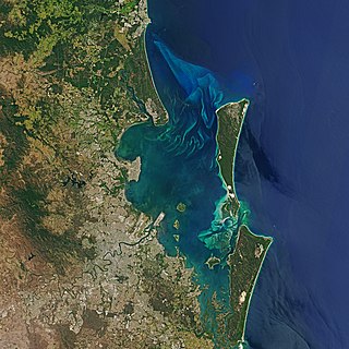
Moreton Bay is a bay located on the eastern coast of Australia 14 kilometres (8.7 mi) from central Brisbane, Queensland. It is one of Queensland's most important coastal resources. The waters of Moreton Bay are a popular destination for recreational anglers and are used by commercial operators who provide seafood to market.

<span class="mw-page-title-main">Moreton Island</span> Island off the Queensland coast, Australia

Moreton Island (Mulgumpin) is an island on the eastern side of Moreton Bay on the coast of South East Queensland, Australia. The Coral Sea lies on the east coast of the island. Moreton Island lies 58 kilometres (36 mi) northeast of the Queensland capital, Brisbane. 98% of the island is contained within a national park and a popular destination for day trippers, four wheel driving, camping, recreational angling and whale watching and a 75-minute ferry ride from Brisbane. It is the third largest sand island in the world. Together with Fraser Island, Moreton Island forms the largest sand structure in the world. It was the traditional country of the Ngugi before settlement.

<span class="mw-page-title-main">Stradbroke Island</span> Island near Brisbane, Australia

Stradbroke Island, also known as Minjerribah, was a large sand island that formed much of the eastern side of Moreton Bay near Brisbane, Queensland until the late 19th century. Today the island is split into two islands: North Stradbroke Island and South Stradbroke Island, separated by the Jumpinpin Channel.

<span class="mw-page-title-main">South Stradbroke Island</span> Suburb of City of Gold Coast, Queensland, Australia

South Stradbroke Island, colloquially South Straddie, is an island that lies within Moreton Bay in the Australian state of Queensland, south of Brisbane and forms the northern end of Gold Coast. The island is a locality within the City of Gold Coast. In the 2021 census, South Stradbroke had a population of 142 people.

<span class="mw-page-title-main">North Stradbroke Island</span> Island that lies within Moreton Bay in the Australian state of Queensland

North Stradbroke Island, colloquially Straddie or North Straddie, is an island that lies within Moreton Bay in the Australian state of Queensland, 30 kilometres (19 mi) southeast of the centre of Brisbane. Originally there was only one Stradbroke Island but in 1896 it split into North Stradbroke Island and South Stradbroke Island separated by the Jumpinpin Channel. The Quandamooka people are the traditional owners of North Stradbroke island.

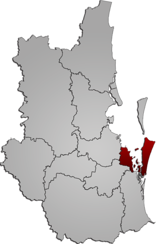
The Division of Bowman is an Australian Electoral Division in Queensland.

<span class="mw-page-title-main">Redland City</span> Local government area in Queensland, Australia

Redland City, better known as the Redlands and formerly known as Redland Shire, is a local government area and a part of the Brisbane metropolitan area in South East Queensland, Australia. With a population of 159,222 in June 2021, the city is spread along the southern coast of Moreton Bay, covering 537.2 square kilometres (207.4 sq mi). Its mainland borders the City of Brisbane to the west and north-west, and Logan City to the south-west and south, while its islands are situated north of the City of Gold Coast.

<span class="mw-page-title-main">Russell Island (Moreton Bay)</span> Suburb of Redland City, Queensland, Australia

Russell Island is an island, a town and a locality in the City of Redland, Queensland, Australia. The island is also known by its traditional Aboriginal name of Canaipa. In the 2021 census, Russell Island had a population of 3,698 people.

Moreton Bay is a locality split between the City of Brisbane and the City of Redland, both in Queensland, Australia. The locality includes all of the bay Moreton Bay between the mainland of the City of Brisbane and the City of Redland across to the western coast of Moreton Island and the western coast of North Stradbroke Island. In the 2021 census, Moreton Bay had a population of 0 people.

<span class="mw-page-title-main">Cleveland, Queensland</span> Suburb of Redland City, Queensland, Australia

Cleveland is a coastal and central locality in the City of Redland, Queensland, Australia. In the 2016 census, Cleveland had a population of 14,801 people.

<span class="mw-page-title-main">Dunwich, Queensland</span> Town in Queensland, Australia

Dunwich is a town and locality on the western side of North Stradbroke Island in Queensland, Australia. Dunwich is part of the Redland City local government area, administered from the bayside town of Cleveland on the Queensland mainland. In the 2016 census, Dunwich had a population of 864 people.

<span class="mw-page-title-main">Redland Bay, Queensland</span> Suburb of Redland City, Queensland, Australia

Redland Bay is a coastal semi-rural locality in the City of Redland, Queensland, Australia. In the 2021 census, Redland Bay had a population of 17,056 people.

Amity is a rural town and locality in the City of Redland, Queensland, Australia. In the 2016 census, the locality of Amity had a population of 387 people.

<span class="mw-page-title-main">Ferry transport in Queensland</span>

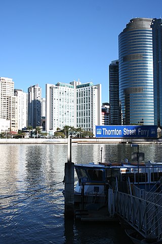
The article Ferry transport in Queensland provides both historical and current information relating to scheduled public passenger ferry services in Queensland. The first ferry started on 1 January 1843 at Russell Street with a service across the Brisbane River.

<span class="mw-page-title-main">Macleay Island</span> Suburb of Brisbane, Queensland, Australia

Macleay Island is an island in Moreton Bay, South East Queensland, Australia. The island constitutes a town and locality within the City of Redland. In the 2016 census, the locality of Macleay Island had a population of 2,681 people.

Karragarra Island is one of the inhabited Southern Moreton Bay Islands, near Brisbane, in Queensland, Australia. It is also a town and locality in the City of Redland, Queensland, Australia. In the 2016 census, the locality of Karragarra Island had a population of 204 people.

<span class="mw-page-title-main">Lamb Island, Queensland</span> Suburb of Brisbane, Queensland, Australia

Lamb Island is a small island which forms part of the Moreton Bay National Marine Park located in the southern part of Moreton Bay, near Brisbane, in Queensland, Australia. It constitutes a town and locality within the Redland City. The south/east side of Lamb Island sits within the Protection and Conservation park zone which is home to protected species of marine life including dugong, dolphins and leatherback turtles. In the 2021 census, the locality of Lamb Island had a population of 504 people.

<span class="mw-page-title-main">Southern Moreton Bay Islands, Queensland</span> Suburb of Gold Coast, Queensland, Australia

Southern Moreton Bay Islands is an island group locality in the north-east of the City of Gold Coast, Queensland, Australia. In the 2021 census, Southern Moreton Bay Islands had no people.

<span class="mw-page-title-main">Lamb Island Pioneer Hall</span> Historic site in Queensland, Australia

Lamb Island Pioneer Hall is a heritage-listed former house and now community hall at Lucas Drive, Lamb Island, City of Redland, Queensland, Australia. It was built from c. 1924 to 1930s. It was added to the Queensland Heritage Register on 3 April 1995.

<span class="mw-page-title-main">Industrial Ruins, Macleay Island</span> Historic site in Queensland, Australia

The Industrial ruins are a heritage-listed archaeological site at Cliff Terrace, Macleay Island, City of Redland, Queensland, Australia. It was built from c. 1869 to c. 1871. It was added to the Queensland Heritage Register on 6 April 1998.

References

  1. "Russell, Karragarra, Lamb and Macleay". Australian Bureau of Census. 2006. Archived from the original on 28 May 2022. Retrieved 28 November 2008.
  2. "Redland (C)" (PDF). Queensland Local Government Areas (LGA), 2011. Queensland Government. Archived from the original (PDF) on 29 October 2013. Retrieved 28 October 2013.
  3. "Search Census data | Australian Bureau of Statistics". www.abs.gov.au. Archived from the original on 15 April 2023. Retrieved 8 February 2024.
  4. "A population boom is changing these islands, but locals say there is no long-term plan". ABC News. 11 August 2022. Archived from the original on 22 October 2023. Retrieved 8 February 2024.
  5. "Lamb Island Pioneer Hall (entry 601493)". Queensland Heritage Register . Queensland Heritage Council. Retrieved 12 July 2013.
  6. 1 2 "Schedule 4 - Heritage Places Register". Redland City Council. Archived from the original on 4 February 2015. Retrieved 3 February 2015.
  7. "Lamb Island". Archived from the original on 4 February 2015. Retrieved 3 February 2015.
  8. "Industrial Ruins, south end of Macleay Island (entry 601062)". Queensland Heritage Register . Queensland Heritage Council. Retrieved 12 July 2013.
  9. Kerr, Judith (17 December 2012). "Bay islands added to Translink network". Brisbane Times. Archived from the original on 29 February 2020. Retrieved 10 March 2020.
  10. "Southern Moreton Bay Islands Vehicle Ferry Timetable". SeaLink South East Queensland. Archived from the original on 28 February 2022. Retrieved 28 February 2022.
  11. Whitlock, Stacey (30 June 2020). "National broadband network switched on for Coochiemudlo, North Stradbroke and Southern Moreton Bay islands". Redland City Bulletin. Archived from the original on 9 July 2020. Retrieved 9 July 2020.