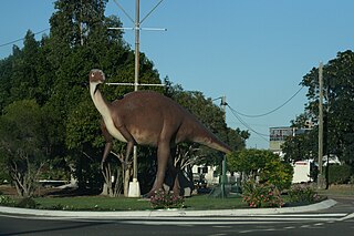
Thargomindah is a rural town and locality in the Shire of Bulloo, Queensland, Australia. The town of Thargomindah is the administrative centre for the Shire of Bulloo. In the 2021 census, the locality of Thargomindah had a population of 243 people.

Hughenden is a rural town and locality in the Flinders Shire, Queensland, Australia. In the 2021 census, the locality of Hughenden had a population of 1,113 people.

Laura is a rural town and locality in the Shire of Cook, Queensland, Australia. In the 2021 census, the locality of Laura had a population of 133 people.

The Flinders River is the longest river in Queensland, Australia, at approximately 1,004 kilometres (624 mi). It was named in honour of the explorer Matthew Flinders. The catchment is sparsely populated and mostly undeveloped. The Flinders rises on the western slopes of the Great Dividing Range in North West Queensland and flows generally north-west through the Gulf Country, across a large, flat clay pan, before entering the Gulf of Carpentaria.

Richmond is a rural town and locality in the Shire of Richmond, Queensland, Australia. In the 2021 census, the locality of Richmond had a population of 578 people.

The Shire of Flinders is a local government area in north-western Queensland, Australia.

The Barcaldine Region is a local government area in Central West Queensland, Australia. Established in 2008, it was preceded by three previous local government areas which had existed for over a century.

Prairie is a rural town and locality in the Flinders Shire, Queensland, Australia. In the 2021 census, the locality of Prairie had a population of 116 people.

Torrens Creek is a rural town and locality in the Shire of Flinders, Queensland, Australia. In the 2021 census, the locality of Torrens Creek had a population of 46 people.

Stamford is a rural town and locality in the Shire of Flinders, Queensland, Australia. In the 2021 census, the locality of Stamford had a population of 77 people.

Corfield is a town and locality in the Shire of Winton in north-western Queensland, Australia. In the 2021 census, the locality of Corfield had a population of 158 people.

Einasleigh is a town and a locality in the Shire of Etheridge, Queensland, Australia. In the 2021 census, the locality of Einasleigh had a population of 87 people.
Gilberton is a rural locality in the Shire of Etheridge, Queensland, Australia. In the 2021 census, the locality of Gilberton had a population of 26 people.

Undullah is a rural locality split between the City of Logan and the Scenic Rim Region, Queensland, Australia. In the 2021 census, Undullah had a population of 24 people.
Tangorin is a rural town and locality in the Flinders Shire, Queensland, Australia. In the 2021 census, the locality of Tangorin had a population of 47 people.

Porcupine is an outback locality in the Shire of Finders, Queensland, Australia. In the 2021 census, Porcupine had a population of 39 people.
Marathon is a rural town and locality in the Flinders Shire, Queensland, Australia. Although the town has existed since c. 1916, the locality was created in November 2021.

Lyndhurst is a rural locality in the Shire of Etheridge, Queensland, Australia. In the 2021 census, Lyndhurst had a population of 11 people.

Talaroo is an outback locality in the Shire of Etheridge, Queensland, Australia. In the 2021 census, Talaroo had a population of 5 people.

Hawkins Creek is a rural locality in the Shire of Hinchinbrook, Queensland, Australia. In the 2021 census, Hawkins Creek had a population of 236 people.


