
The Burdekin River is a river located in North and Far North Queensland, Australia. The river rises on the northern slopes of Boulder Mountain at Valley of Lagoons, part of the western slope of the Seaview Range, and flows into the Coral Sea at Upstart Bay over 200 kilometres (124 mi) to the southeast of the source, with a catchment area of approximately 130,000 square kilometres (50,000 sq mi). The Burdekin River is Australia's largest river by (peak) discharge volume.

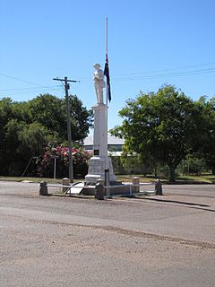
Barcaldine is a rural town and locality in the Barcaldine Region in Queensland, Australia. In the 2016 census, Barcaldine had a population of 1,422 people. This is the administrative centre of the Barcaldine Region. Barcaldine played a major role in the Australian labour movement.
Aramac is a rural town and locality in the Barcaldine Region, Queensland, Australia. In the 2016 census, Aramac had a population of 299 people.

Muttaburra is a town and locality in the Barcaldine Region, Queensland, Australia. In the 2016 census, Muttaburra had a population of 88 people. The undeveloped town of Scarrbury is within the locality.

Alpha is a rural town and a locality in the Barcaldine Region, Queensland, Australia. In the 2016 census, Alpha had a population of 335 people.

Jericho is a rural town and locality in the Barcaldine Region, Queensland, Australia. In the 2016 census, Jericho had a population of 115 people.

The Barcaldine Region is a local government area in Central West Queensland, Australia. Established in 2008, it was preceded by three previous local government areas which had existed for over a century.

The Mount Perry Branch Railway is a closed railway line in Central Queensland, Australia. In 1869 copper was discovered at Mount Perry and the township grew rapidly. A railway to the coast was essential to provide cheap transport and make the mining of low percentage ore viable. Maryborough and Bundaberg vied for the opportunity to be the terminus and the latter city was successful.
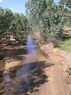
The Alice River in central Queensland, Australia rises on the western slopes of the Great Dividing Range. The river bisects the Shire of Barcaldine, flowing in a south-westerly direction towards Isisford and its confluence with the Barcoo River. The town of Barcaldine is located on the Alice River. The Alice River's tributaries include Jordan Creek and Lagoon Creek. The Alice River is often dry, except after the annual summer rains.
Evora is a former rural locality in the Barcaldine Region, Queensland, Australia. In the 2016 census, Evora had a population of 0 people.
Grant is a former rural locality in the Barcaldine Region, Queensland, Australia. In the 2016 census, Grant had a population of 11 people.
Tara Station is a former rural locality in the Barcaldine Region, Queensland, Australia. In the 2016 census, Tara Station had a population of 10 people.
Beaufort is a former rural locality in the Barcaldine Region, Queensland, Australia. In the 2016 census, Beaufort had a population of 46 people. On 22 November 2019 the Queensland Government decided to amalgamate the localities in the Barcaldine Region, resulting in five expanded localities based on the larger towns: Alpha, Aramac, Barcaldine, Jericho and Muttaburra. Beaufort was incorporated into Alpha.
Drummondslope is a former rural locality in the Barcaldine Region, Queensland, Australia. In the 2016 census, Drummondslope had a population of 43 people. On 22 November 2019 the Queensland Government decided to amalgamate the localities in the Barcaldine Region, resulting in five expanded localities based on the larger towns: Alpha, Aramac, Barcaldine, Jericho and Muttaburra. Drummondslope was incorporated into Alpha.
Garfield is a former rural locality in the Barcaldine Region, Queensland, Australia. In the 2016 census, Garfield had a population of 37 people.

Hobartville is a former rural locality in the Barcaldine Region, Queensland, Australia. In the 2016 census, Hobartville had a population of 50 people.
Mexico is a former rural locality in the Barcaldine Region, Queensland, Australia. In the 2016 census, Mexico had a population of 26 people.

Pine Hill is a former rural locality in the Barcaldine Region, Queensland, Australia. In the 2016 census, Pine Hill had a population of 3 people.
Port Wine is a former rural locality in the Barcaldine Region, Queensland, Australia. In the 2016 census, Port Wine had a population of 27 people.
Sedgeford is a former rural locality in the Barcaldine Region, Queensland, Australia. In the 2016 census, Sedgeford had a population of 0 people.
