Alice River (Barcoo River)

Last updated

Alice River
Alice River QLD.JPG
Alice River, near the Landsborough Highway
Lake eyre basin map.png
Map of the Lake Eyre Basin showing Barcoo River
Location
Country Australia
State Queensland
Physical characteristics
Source Great Dividing Range
  locationeast of Aramac, Central Queensland
Mouth confluence with the Barcoo River
  location
north-east of Isisford
  elevation
225 m (738 ft)
Length303 km (188 mi)
Basin features
River system Barcoo River, Lake Eyre basin

The Alice River in central Queensland, Australia rises on the western slopes of the Great Dividing Range. The river bisects the Shire of Barcaldine, flowing in a south-westerly direction towards Isisford and its confluence with the Barcoo River to form Cooper Creek. Barcaldine is located on Lagoon Creek, which flows into the Alice River approximately five kilometre s to the south. The Alice River is often dry, except after the annual summer rains.

Contents

The Barcoo River forms the boundary of outback Australia with little in the way of civilization west of the Barcoo. Waters from the Barcoo and Alice Rivers flow towards Lake Eyre in Central Australia, while rivers further east join the Murray-Darling basin and reach the sea in South Australia.

History

The traditional owners of the area are the Iningai peoples. Iningai (also known as Yiningay, Muttaburra, Tateburra, Yinangay, Yinangi) is an Australian Aboriginal language spoken by the Iningai people. The Iningai language region includes the landscape within the local government boundaries of the Longreach Region and Barcaldine Region, particularly the towns of Longreach, Barcaldine, Muttaburra and Aramac as well as the properties of Bowen Downs and catchments of Cornish Creek and Alice River. [1]

In 1846, Thomas Mitchell became the first European to see the Barcoo and Alice Rivers. The Alice River was named by Mitchell and Mitchell's name was adopted for the pastoral district and for its grass, Mitchell grass. [2] In October 1863, Donald Cameron, his son John, together with James and William Crombie walked sheep from the New England district of New South Wales and grazed them along a 40-mile frontage of the Alice River. They named their property Barcaldine after a family farm in Scotland. [3]

In 1891 the Alice River had a record flood that stopped traffic for a week. On 20 March 1910 the Alice River flooded all the low-lying country and the railway line was blocked. [4]

See also

Related Research Articles

Longreach, Queensland Town in Queensland, Australia

Longreach is a town and a locality in the Longreach Region, Queensland, Australia. In the 2016 census, Longreach had a population of 2,970 people. It is the administrative centre of the Longreach Regional Council, which was established in 2008 as a merger of the former Longreach, Ilfracombe, and Isisford shires.

Barcoo River river

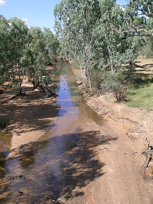
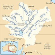
The Barcoo River in western Queensland, Australia rises on the northern slopes of the Warrego Range, flows in a south-westerly direction and unites with the Thomson River to form Cooper Creek. The first European to see the river was Thomas Mitchell in 1846, who named it Victoria River, believing it to be the same river as that named Victoria River by J. C. Wickham in 1839. It was renamed by Edmund Kennedy after a name supplied by local Aborigines.

Barcaldine, Queensland Town in Queensland, Australia

Barcaldine is a rural town and locality in the Barcaldine Region in Queensland, Australia. In the 2016 census, Barcaldine had a population of 1,422 people. This is the administrative centre of the Barcaldine Region. Barcaldine played a major role in the Australian labour movement.

Aramac, Queensland Town in Queensland, Australia

Aramac is a rural town and locality in the Barcaldine Region, Queensland, Australia. In the 2016 census, Aramac had a population of 299 people.

Thomson River (Queensland) river in Queensland, Australia

The Thomson River is a perennial river that forms part of the Lake Eyre Basin, situated in the central west and western regions of Queensland, Australia. Much of the course of the river comprises a series of narrow channels synonymous with the Channel Country and the Gailee subregion.

Muttaburra Town in Queensland, Australia

Muttaburra is a town and locality in the Barcaldine Region, Queensland, Australia. In the 2016 census, Muttaburra had a population of 88 people. The undeveloped town of Scarrbury is within the locality.

Barcaldine Region Local government area in Queensland, Australia

The Barcaldine Region is a local government area in Central West Queensland, Australia. Established in 2008, it was preceded by three previous local government areas which had existed for over a century.

Longreach Region Local government area in Queensland, Australia

The Longreach Region is a local government area in Central West Queensland, Australia. Established in 2008, it superseded three previous local government areas that had existed for more than a century.

Central West Queensland Region in Queensland, Australia

Central West Queensland is a remote region in the Australian state of Queensland which covers 396 650.2 km². The region lies to the north of South West Queensland and south of the Gulf Country.

Bowen Downs Station pastoral lease and cattle station in Queensland, Australia

Bowen Downs Station is a pastoral lease that has operated both as a cattle station and a sheep station.

Bexley Station (Queensland)

Bexley Station is a pastoral lease that operates as a sheep station in Queensland.

Cornish Creek, Queensland Suburb of Barcaldine Region, Queensland, Australia

Cornish Creek is a locality in the Barcaldine Region, Queensland, Australia. In the 2016 census, Cornish Creek had a population of 16 people.

The Iningai (Yiningayi) were an indigenous Australian people of the present-day Longreach Region in the state of Queensland.

Tablederry, Queensland Suburb of Barcaldine Region, Queensland, Australia

Tablederry is a locality in the Barcaldine Region, Queensland, Australia. In the 2016 census, Tablederry had a population of 32 people.

Bangall, Queensland Suburb of Barcaldine Region, Queensland, Australia

Bangall is a locality in the Barcaldine Region, Queensland, Australia. In the 2016 census, Bangall had a population of 4 people.

Pelican Creek, Queensland Suburb of Barcaldine Region, Queensland, Australia

Pelican Creek is a locality in the Barcaldine Region, Queensland, Australia. In the 2016 census, Pelican Creek had a population of 20 people.

Sardine, Queensland Suburb of Barcaldine Region, Queensland, Australia

Sardine is a locality in the Barcaldine Region, Queensland, Australia. In the 2016 census, Sardine had a population of 5 people.

Barcaldine Downs Suburb of Barcaldine Region, Queensland, Australia

Barcaldine Downs is a rural locality in the Barcaldine Region, Queensland, Australia. In the 2016 census, Barcaldine Downs had a population of 14 people.

Moombria, Queensland Suburb of Barcaldine Region, Queensland, Australia

Moombria is a locality in the Barcaldine Region, Queensland, Australia. In the 2016 census, Moombria had a population of 0 people.

Tara Station, Queensland Suburb of Barcaldine Region, Queensland, Australia

Tara Station is a locality in the Barcaldine Region, Queensland, Australia. In the 2016 census, Tara Station had a population of 10 people.

References

  1. "Iningai". State Library of Queensland . Retrieved 15 January 2020.
  2. "Chisholm, Alec H.". The Australian Encyclopaedia. 1. Sydney: Halstead Press. 1963. p. 406. Barcoo River.
  3. "BARCALDINE HISTORY". SunZine. Retrieved 5 July 2011.
  4. "QUEENSLAND FLOOD SUMMARY 1910 - 1919". Bureau of Meteorology. Commonwealth of Australia. Retrieved 5 July 2011.

Coordinates: 23°23′S145°08′E / 23.39°S 145.13°E / -23.39; 145.13