Port Douglas Wharf

Last updated

Port Douglas Wharf
Port Douglas Wharf, Queensland, 2020 02.jpg
Port Douglas Wharf and Storage Shed, 2020
Location6 Dixie Street, Port Douglas, Shire of Douglas, Queensland, Australia
Coordinates 16°28′48″S145°27′39″E / 16.48°S 145.4608°E / -16.48; 145.4608
Design period1900–1914 (early 20th century)
Built1904
Official namePort Douglas Wharf and Storage Shed (former), Port Douglas Wharf and Shipwreck Museum
Typestate heritage (built)
Designated21 October 1992
Reference no.600466
Significant period1900s–1950s (historical)
Significant componentspile/s, shed – storage, wharf/dock/quay
Australia Queensland location map.svg
Red pog.svg
Location of Port Douglas Wharf in Queensland
Australia location map.svg
Red pog.svg
Port Douglas Wharf (Australia)

Port Douglas Wharf is a heritage-listed wharf at 6 Dixie Street, Port Douglas, Shire of Douglas, Queensland, Australia. It was built in 1904. It was also known as Shipwreck Museum. It was added to the Queensland Heritage Register on 21 October 1992. [1]

Contents

History

Port Douglas Wharf and Storage Shed were erected in 1904 for the Douglas Shire Council, the buildings reported demolished by the cyclone of 1911, [2] with extensions to the storage shed made in the 1920s. [1]

Port Douglas was established in 1877 as a port to service the newly opened Hodgkinson Goldfield, west of the Great Dividing Range. In the period 1877 to 1893, Port Douglas functioned primarily as a port for the mining hinterland and secondarily as an administrative and service centre for the surrounding developing agricultural districts. The development of Port Douglas initially outpaced that of its nearby rival, Cairns, established in 1876. However, following the 1885 political decision to site the terminus for the Atherton Tableland Railway at Cairns, this town advanced rapidly at the expense of Port Douglas. After the opening of the Cairns to Mareeba railway in 1893, trade between Port Douglas and the mining hinterland declined markedly, and virtually ceased after the extension of the railway to Mount Molloy in 1908. Much of what remained of the township was further decimated in a severe cyclone on 16 March 1911. [1] [2]

However, from the 1890s until 1958, Port Douglas survived principally as a sugar port. The town was also the administrative centre of Douglas Shire until the 1920s, when headquarters were shifted to Mossman in the heart of the expanding sugar lands. During the 1960s and 1970s, Port Douglas functioned mainly as a fishing and holiday town, retaining much of its historic character, but in the 1980s the town emerged as a booming tourist resort, with strong pressures for development. [1]

It appears that the wharf was built to serve the handling of general cargo (as opposed to sugar) in preference to at least one other previous proposal for a jetty at Macrossan Street. Prior to this, it seems that all general cargo handling was carried out at the private wharfing facilities (variously Walsh & Co., Davidson's, Jack & Newell and possibly others), either by direct berthing for smaller vessels or for larger vessels by lightering from the general anchorage some 600 metres (2,000 ft) off the western end of Island Point. A stone-pitched jetty adjacent to the quarry site on the north-east corner of Island Point had been constructed earlier for passenger traffic, and was extended during 1888–1889 to a total length of 60 metres (200 ft). [1]

In 1904, Douglas Shire Council obtained a loan from the Queensland Government to build a new wharf for the berthing of ships at a more convenient site in the harbour. This wharf was built with a decline from wharf to shore to ease the transfer of loaded rail trucks. A stone pitched ramp was built as part of the wharf construction. The 1904 wharf structure was about 15 metres (49 ft) wide, with a storage shed 30 metres (98 ft) long by 8 metres (26 ft) wide on the north-east corner of the decking. A jib crane was located on the northern end of the wharf and walkways were constructed alongside the storage shed. [1]

During the early 1920s an additional row of piles was driven about 3 metres (9.8 ft) to the east along the length of the wharf. The 1904 storage shed was relocated over these by sliding the structure back from the wharf outer face. It appears that at this period the shed was extended on the southern end by about 12 metres (39 ft). A lunch room building, also holding a fresh water tank, on the southern end of the storage shed was relocated to the same respective position when the shed was extended. [1]

The ship Kuranda at Port Douglas wharf, 1917 StateLibQld 1 144919 Kuranda (ship) at Port Douglas wharf, ca. 1917.jpg
The ship Kuranda at Port Douglas wharf, 1917

The wharf was last used for sugar shipment on 1 April 1958. Subsequently, the wharf was leased for private enterprise from 1963 until January 1975. Well known Queensland diver Ben Cropp held a twenty-year lease over the storage shed from October 1979. He operated a shipwreck museum in the shed which also included his living quarters. The lease was briefly extended into mid-2000. Cropp relocated the museum to Cairns later that year. [1]

The foreshore near the Port Douglas Wharf was reclaimed in the late twentieth century, and the 1904 timber-piled and timber-framed jetty between the stone-pitched ramp and the storage shed was removed. [1]

Description

Wharf as part of the Port Douglas waterfront, 2015 Waterfront, Port Douglas, 2015 (02).JPG
Wharf as part of the Port Douglas waterfront, 2015

This wharf is at the entrance to Dickson's Inlet approximately opposite the western end of Warner Street. [1]

The wharf, which is constructed parallel to the channel, is of timber construction about 70 metres (230 ft) long (including the decked approach ramp) by 18 metres (59 ft) wide and supporting a wooden storage shed on the eastern side. [1]

The storage shed roof trusses are constructed from 300 by 150 millimetres (11.8 in × 5.9 in) and 200 by 150 millimetres (7.9 in × 5.9 in) sections, mainly Oregon, and the storage shed was planked internally to facilitate the stacking of bagged sugar. [1]

A simple gable roofed form building, the former wharf storage building is built out over the water on timber piles braced by diagonal timbers. [1]

The new corrugated steel roof is exposed internally and supported on burlings spanning between major trusses of mainly Oregon members. Timber planes fixed with dogspikes form the floor. [1]

The building is an important element in the townscape of Port Douglas, being most visible from the sea and surrounding hills. [1]

An earlier stone pitched ramp remains in evidence at the side of the later earth-filled access to the former storage shed and wharf. [1]

Heritage listing

The former Port Douglas Wharf and Storage Shed was listed on the Queensland Heritage Register on 21 October 1992 having satisfied the following criteria. [1]

The place is important in demonstrating the evolution or pattern of Queensland's history.

The building is significant for its historical association with the development of Port Douglas as a shipping terminal. [1]

Related Research Articles

<span class="mw-page-title-main">Port Douglas</span> Town in Queensland, Australia

Port Douglas is a coastal town and locality in the Shire of Douglas, Queensland, Australia, approximately 60 km north of Cairns. In the 2021 census, Port Douglas had a population of 3,650 people. The town's population can often double, however, with the influx of tourists during the peak tourism season from May to September. The town is named in honour of a former Premier of Queensland, John Douglas. Port Douglas developed quickly based on the mining industry. Other parts of the area were established with timber cutting in the area surrounding the Daintree River and with settlement starting on lots around the Mossman River by 1880.

<span class="mw-page-title-main">Finger Wharf</span> Historic site in New South Wales, Australia

The Finger Wharf is a heritage-listed former wharf and passenger terminal and now marina, residential apartments, hotel and restaurant located at 6 Cowper Wharf Road, in the inner city Sydney suburb of Woolloomooloo, Australia. It was designed by Henry D. Walsh and built from 1910 to 1915 by the Sydney Harbour Trust. It is also known as Woolloomooloo Finger Wharf and Woolloomooloo Wharf. The property is owned by Transport for NSW. The structure is the longest timbered-piled wharf in the world.

<span class="mw-page-title-main">Howard Smith Wharves</span> Historic site in Queensland, Australia

Howard Smith Wharves is a heritage-listed wharf on the Brisbane River at Boundary Street, Brisbane City and Fortitude Valley, City of Brisbane, Queensland, Australia. It was built from c. 1934 to 1940s circa. It is also known as Brisbane Central Wharves. The 3.5-hectare (8.6-acre) site is one of the most culturally and historically significant riverfront locations in Brisbane. It was added to the Queensland Heritage Register on 4 February 1997.

<span class="mw-page-title-main">William Street retaining wall</span> Historic embankment in Brisbane, Queensland

William Street retaining wall is a heritage-listed embankment at William Street, Brisbane City, City of Brisbane, Queensland, Australia. It was built from 1889 to 1970s. It is also known as William Street & Queens Wharf Road retaining walls and North Quay porphry wall. It was added to the Queensland Heritage Register on 21 October 1992.

Ipswich Town Wharves are heritage-listed remnants of wharves beside the Bremer River at Bremer Street, North Ipswich, City of Ipswich, Queensland, Australia. They were built from 1847 to c. 1927. They were also known as Australasian Steam Navigation Wharf and William Collins and Son Wharf, J & G Harris Wharf, and Walter Gray and Co Wharf. They were added to the Queensland Heritage Register on 31 July 2006.

<span class="mw-page-title-main">Dunethin Rock</span> Historic site in Queensland, Australia

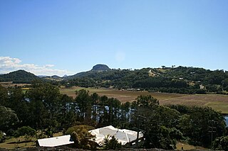
Dunethin Rock is a heritage-listed park at Dunethin Rock Road, Maroochy River, Sunshine Coast Region, Queensland, Australia. It was added to the Queensland Heritage Register on 5 February 2009.

<span class="mw-page-title-main">Gin Gin railway station</span> Historic site in Queensland, Australia

Gin Gin railway station is a heritage-listed railway station at Mulgrave Street, Gin Gin, Bundaberg Region, Queensland, Australia. It was built from 1888 to c. 1928. It is also known as Gin Gin Railway Station, Goods Shed & Refreshment Rooms. It was added to the Queensland Heritage Register on 28 July 2000.

<span class="mw-page-title-main">McCowat's Farm</span> Historic site in Queensland, Australia

McCowat's Farm is a heritage-listed plantation at McCowat Road, Garradunga, Cassowary Coast Region, Queensland, Australia. It was built in 1920 by William Purdy. It is also known as Koodla. It was added to the Queensland Heritage Register on 21 October 1992.

<span class="mw-page-title-main">St Saviour's Anglican Church, South Johnstone</span> Historic site in Queensland, Australia

St Saviour's Anglican Church is a heritage-listed former church building at 26 Hynes Street, South Johnstone, Cassowary Coast Region, Queensland, Australia. It was built from 1938 to 1939 by Mose Romano. It was added to the Queensland Heritage Register on 24 September 2004.

<span class="mw-page-title-main">St David's Anglican Church, Mossman</span> Historic site in Queensland, Australia

St David's Anglican Church is a heritage-listed church at 3 Foxton Avenue, Mossman, Shire of Douglas, Queensland, Australia. It was designed by Edward Taffs and Edwin Roy Orchard. It was added to the Queensland Heritage Register on 6 August 2010.

<span class="mw-page-title-main">WWII RAN Fuel Installation, Edge Hill</span> Historic site in Queensland, Australia

WWII RAN Fuel Installation is a heritage-listed former fuel depot and now arts centre at Collins Avenue, Edge Hill, Cairns, Cairns Region, Queensland, Australia. It was built in 1943. It was added to the Queensland Heritage Register on 2 February 2007.

<span class="mw-page-title-main">Cairns-to-Kuranda railway line</span> Railway line in Queensland, Australia

The Cairns-to-Kuranda Railway is a heritage-listed railway line from the Cairns Region to the Shire of Mareeba, both in Queensland, Australia. It commences at Redlynch, a suburb of Cairns and travels up the Great Dividing Range to Kuranda within the Shire of Mareeba on the Atherton Tableland. It was built from 1913 to 1915 by Queensland Railways. Components of it include Stoney Creek Bridge, the Rail Bridge over Christmas Creek, Kuranda railway station, and Surprise Creek Rail Bridge. It was added to the Queensland Heritage Register on 21 August 1992. The railway is used to operate a tourist rail service, the Kuranda Scenic Railway. It forms part of the Tablelands railway line.

<span class="mw-page-title-main">Cairns City Council Chambers</span> Historic site in Queensland, Australia

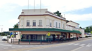
Cairns City Council Chambers is a heritage-listed former town hall and now council library at 151 Abbott Street, Cairns City, Cairns, Cairns Region, Queensland, Australia. It was designed by Hill & Taylor and built from 1929 to 1930 by Alex McKenzie. It was added to the Queensland Heritage Register on 5 October 1998. It is now home to the Cairns City Library.

<span class="mw-page-title-main">Barrier Reef Hotel</span> Historic site in Queensland, Australia

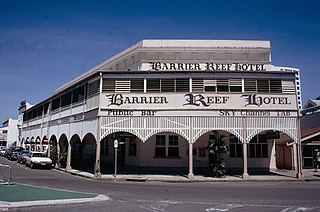
Barrier Reef Hotel is a heritage-listed hotel at Abbott Street, Cairns City, Cairns, Cairns Region, Queensland, Australia. It was designed by Lawrence and Lordan in conjunction with Richard Hill built in 1926 by Carl Peter Jorgensen. It was also known as Empire Hotel. It was added to the Queensland Heritage Register on 29 July 1997.

<span class="mw-page-title-main">Mulgrave Shire Council Chambers</span> Historic site in Queensland, Australia

Mulgrave Shire Council Chambers is a heritage-listed former town hall at 51 The Esplanade, Cairns City, Cairns, Cairns Region, Queensland, Australia. It was designed by Charles Dalton Lynch & Walter Hunt and built from 1912 to 1913 by Wilson & Baillie. It is also known as Cairns Shire Offices. It was added to the Queensland Heritage Register on 6 January 1999.

<span class="mw-page-title-main">Cairns Wharf Complex</span> Historic site in Queensland, Australia

Cairns Wharf Complex is a heritage-listed wharf at Wharf Street, Cairns City, Cairns, Cairns Region, Queensland, Australia. It was built from 1910 to 1948. It was added to the Queensland Heritage Register on 17 December 1999.

<span class="mw-page-title-main">St Mary's by the Sea, Port Douglas</span> Church in Australia

St Mary's by the Sea is a heritage-listed non-denominational church at Wharf Street, Port Douglas, Shire of Douglas, Queensland, Australia. It was built from 1913 to 1914. It is also known as the former St Mary's Roman Catholic Church. It was added to the Queensland Heritage Register on 21 October 1992.

<span class="mw-page-title-main">Mossman Shire Hall and Douglas Shire Council Chambers</span> Historic site in Queensland, Australia

Mossman Shire Hall and Douglas Shire Council Chambers is a heritage-listed former town hall at 8-14 Mill Street, Mossman, Shire of Douglas, Queensland, Australia. It was designed by Hill & Taylor and built in 1937 by Tarmey & Euhus. It was added to the Queensland Heritage Register on 6 August 2010.

<span class="mw-page-title-main">National Bank of Australasia Building, Mossman</span> Historic site in Queensland, Australia

National Bank of Australasia Building is a heritage-listed former bank at 11 Mill Street, Mossman, Shire of Douglas, Queensland, Australia. It was designed by Lange Leopold Powell and built from 1935 to 1936 by Arthur E Zillfleisch and Tom Booth. It was added to the Queensland Heritage Register on 6 August 2010.

<span class="mw-page-title-main">Exchange Hotel, Mossman</span> Historic site in Queensland, Australia

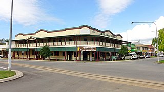
Exchange Hotel is a heritage-listed hotel at 2 Front Street, Mossman, Shire of Douglas, Queensland, Australia. It was designed by Vibert McKirdy Brown and built from 1934 to 1935. It was also known as Daintree Inn. It was added to the Queensland Heritage Register on 9 November 2012.

References

  1. 1 2 3 4 5 6 7 8 9 10 11 12 13 14 15 16 17 18 "Port Douglas Wharf and Storage Shed (former) (entry 600466)". Queensland Heritage Register . Queensland Heritage Council. Retrieved 1 August 2014.
  2. 1 2 "A DEVASTATING CALAMITY". The Brisbane Courier. No. 16, 597. Queensland, Australia. 22 March 1911. p. 5. Retrieved 14 April 2017 via National Library of Australia.

Attribution

CC-BY-icon-80x15.png This Wikipedia article was originally based on "The Queensland heritage register" published by the State of Queensland under CC-BY 3.0 AU licence (accessed on 7 July 2014, archived on 8 October 2014). The geo-coordinates were originally computed from the "Queensland heritage register boundaries" published by the State of Queensland under CC-BY 3.0 AU licence (accessed on 5 September 2014, archived on 15 October 2014).

Commons-logo.svg Media related to Port Douglas Wharf at Wikimedia Commons