The Stʼatʼimc, also known as the Lillooet, St̓át̓imc, or Stl'atl'imx, are an Interior Salish people located in the southern Coast Mountains and Fraser Canyon region of the Interior of the Canadian province of British Columbia.
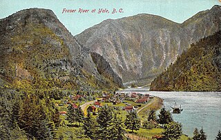
Yale is an unincorporated town in the Canadian province of British Columbia, which grew in importance during the Fraser Canyon Gold Rush.

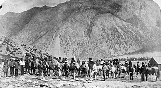
The Cariboo Road was a project initiated in 1860 by the Governor of the Colony of British Columbia, James Douglas. It involved a feat of engineering stretching from Fort Yale to Barkerville, B.C. through extremely hazardous canyon territory in the Interior of British Columbia.

The Fraser Canyon Gold Rush, began in 1858 after gold was discovered on the Thompson River in British Columbia at its confluence with the Nicoamen River a few miles upstream from the Thompson's confluence with the Fraser River at present-day Lytton. The rush overtook the region around the discovery and was centered on the Fraser Canyon from around Hope and Yale to Pavilion and Fountain, just north of Lillooet.
The Skatin First Nations, aka the Skatin Nations, are a band government of the In-SHUCK-ch Nation, a small group of the larger St'at'imc people who are also referred to as Lower Stl'atl'imx. The Town of Skatin - the St'at'imcets version of the Chinook Jargon Skookumchuck- is located 4 km south of T'sek Hot Spring- alt. spelling T'sek Hot Spring - commonly & formerly named both St. Agnes' Well & Skookumchuck Hot Springs The community is 28 km south of the outlet of Lillooet Lake on the east side of the Lillooet River. It is approximately 75 km south of the town of Pemberton and the large reserve of the Lil'wat branch of the St'at'imc at Mount Currie. Other bands nearby are Samahquam at Baptiste Smith IR on the west side of the Lillooet River at 30 km. and Xa'xtsa First Nations; the latter is located at Port Douglas, near the mouth of the Lillooet River where it enters the head of Harrison Lake. The N'Quatqua First Nation on Anderson Lake, between Mount Currie and Lillooet, was at one time involved in joint treaty negotiations with the In-SHUCK-ch but its members have voted to withdraw, though a tribal council including the In-SHUCK-ch bands and N'Quatqua remains, the Lower Stl'atl'imx Tribal Council.

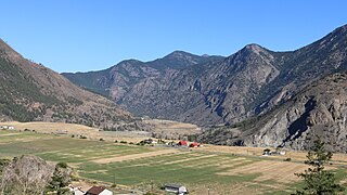
The Lillooet River is a major river of the southern Coast Mountains of British Columbia. It begins at Silt Lake, on the southern edge of the Lillooet Crown Icecap about 80 kilometres northwest of Pemberton and about 85 kilometres northwest of Whistler. Its upper valley is about 95 kilometres in length, entering Lillooet Lake about 15 km downstream from Pemberton on the eastern outskirts of the Mount Currie reserve of the Lil'wat branch of the St'at'imc people. From Pemberton Meadows, about 40 km upstream from Pemberton, to Lillooet Lake, the flat bottomlands of the river form the Pemberton Valley farming region.

Lillooet Lake is a lake in British Columbia, Canada about 25 km in length and about 33.5 square kilometres (22 mi²) in area. It is about 95 km downstream from the source of the Lillooet River, which resumes its course after leaving Little Lillooet Lake, aka Tenas Lake. Immediately adjacent to the mouth of the upper Lillooet River is the mouth of the Birkenhead River and just upstream along the Lillooet is the confluence of the Green River, which begins at Green Lake in the resort area of Whistler.
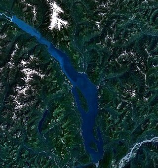
Harrison Lake is the largest lake in the southern Coast Mountains of Canada, being about 250 square kilometres (95 mi²) in area. It is about 60 km (37 mi) in length and at its widest almost 9 km (5.6 mi) across. Its southern end, at the resort community of Harrison Hot Springs, is c. 95 km east of downtown Vancouver. East of the lake are the Lillooet Ranges while to the west are the Douglas Ranges. The lake is the last of a series of large north-south glacial valleys tributary to the Fraser along its north bank east of Vancouver, British Columbia. The others to the west are the Chehalis, Stave, Alouette, Pitt, and Coquitlam Rivers. Harrison Lake is a natural lake, not man-made. The lake is supplied primarily from the Lillooet River, which flows into the lake at the northernmost point.
The Douglas Road, a.k.a. the Lillooet Trail, Harrison Trail or Lakes Route, was a goldrush-era transportation route from the British Columbia Coast to the Interior. Over 30,000 men are reckoned to have travelled the route in, although by the end of the 1860s it was virtually abandoned due to the construction of the Cariboo Wagon Road, which bypassed the region.
The Harrison River is a short but large tributary of the Fraser River, entering it near the community of Chehalis, British Columbia, Canada. The Harrison drains Harrison Lake and is the de facto continuation of the Lillooet River, which feeds the lake.
The Birkenhead River, formerly known as the Portage River, the Pole River and the Mosquito River, is a major tributary of the Lillooet River, which via Harrison Lake and the Harrison River is one of the major tributaries of the lower Fraser River. It is just over 50 km long from its upper reaches in the unnamed ranges south of Bralorne, British Columbia ; their western area towards the named Bendor Range east of Bralorne is sometimes called the Cadwallader Ranges.

The Lil'wat First Nation, a.k.a. the Lil'wat Nation or the Mount Currie Indian Band, is a First Nation band government located in the southern Coast Mountains region of the Interior of the Canadian province of British Columbia. It is a member of the Lillooet Tribal Council, which is the largest grouping of band governments of the St'at'imc or Stl'atl'imx people. Other St'at'imc governments include the smaller In-SHUCK-ch Nation on the lower Lillooet River to the southwest, and the independent N'quatqua First Nation at the near end of Anderson Lake from Mount Currie, which is the main reserve of the Lil'wat First Nation, and also one of the largest Indian reserves by population in Canada.
The Lakes Route is an alternate name for the Douglas Road, which was the first formally designated "road" into the Interior of British Columbia, Canada from its Lower Mainland area flanking the Lower Fraser River. Also known as the Douglas-Lillooet Trail or the Lillooet Trail, the route consisted of a series of wagon roads connected via lake travel in between. A variety of craft were used on the lakes, from steamboats to sail-driven rafts to, through the early 20th Century, diesel and other engines. Lake travel continued for commerce, passenger travel and heavy freight until after World War II.
Fountain is an unincorporated rural area and Indian reserve community in the Fraser Canyon region of British Columbia, Canada, located at the ten-mile (16 km) mark from the town of Lillooet on BC Highway 99, which in that area is also on the route of the Old Cariboo Road and is located at the junction of that route with the old gold rush-era trail via Fountain Valley and the Fountain Lakes.
Skatin is a community of under 100 persons in Skatin First Nations, aka the Skatin Nations, a Band government of the larger Band of the In-SHUCK-ch Nation, part of the St'at'imc people who are also referred to as Lower Stl'atl'imx. Skatin, the official new name, reverts to the traditional pre-colonial/pre-Columbian name. The alternate past name still commonly used by outsiders, Skookumchuck, is the St'at'imcets version of the Chinook Jargon Skookumchuck, meaning Strong Waters, i.e. rapids. The town site is 4 km south of T'sek Hot Spring, formerly named both Saint Agnes Well and Skookumchuck Hot Springs. The community is 28 km south of the outlet of Lillooet Lake on the east side of the Lillooet River. It is approximately 75 km south of the town of Pemberton and the large reserve of the Lil'wat branch of the St'at'imc at Mount Currie, British Columbia. See Skatin First Nations for details about the complicated Band(s) structure.

Cayoosh Creek is a northeast-flowing tributary of the Seton River in the Canadian province of British Columbia. The name Cayoosh Creek remains on the bridge-sign crossing the stream on BC Highway 99 and continues in use locally to refer to the final reaches of the Seton River, formerly Seton Creek, which prior to the renaming ending at the confluence with Cayoosh Creek. The creek is the namesake of Cayoosh Creek Indian Reserve No. 1, one of the main Indian reserves of the Cayoose Creek Indian Band, which lies adjacent to what was renamed the Seton River without local consultation.
The Bridge River Rapids, also known as the Six Mile Rapids, the Lower Fountain, the Bridge River Fishing Grounds, and in the St'at'imcets language as Sat' or Setl, is a set of rapids on the Fraser River, located in the central Fraser Canyon at the mouth of the Bridge River six miles north of the confluence of Cayoosh Creek with the Fraser and on the northern outskirts of the District of Lillooet, British Columbia, Canada.
The Douglas First Nation, aka the Douglas Indian Band, Douglas Band, or Xa'xtsa First Nation, are a band government of the In-SHUCK-ch Nation, a subgroup of the larger St'at'imc people, also referred to as Lower Stl'atl'imx. The Douglas, Skatin and Samahquam communities are related through familial ties as well as culturally and linguistically. The In-SHUCK-ch are the southernmost of the four divisions making up the Lillooet ethnographic group. The Douglas First Nation's main community is at Xa'xtsa, a village on their main reserve at the head of Harrison Lake, near the former gold rush port-town of Port Douglas.
The New Westminster Land District is one of 59 land districts of British Columbia, Canada, which are the underlying cadastral divisions of that province, created with rest of those on Mainland British Columbia via the Lands Act of the Colony of British Columbia in 1860. The British Columbia government's BC Names system, a subdivision of GeoBC, defines a land district as "a territorial division with legally defined boundaries for administrative purposes". All land titles and surveys use the Land District system as the primary point of reference, and entries in BC Names for placenames and geographical objects are so listed.
Little Lillooet Lake, historically also Tenas Lake is a lake in the Lower Lillooet Country located to the south of Pemberton, British Columbia, Canada, turning off highway 99 on the FSR to 33 km. along the course of the Lillooet River, which continues southwards beyond it to Harrison Lake. Still formally a separate lake, historically construction of a small dam to enable steamer service to Port Pemberton, which lay at the head of Lillooet Lake, its northern neighbour and parent waterflow, during the construction of the Lakes Route during the Fraser Canyon Gold Rush. "Tenas" or "tenass" in Chinook Jargon means "small" or "child" and was an alternate name for this lake, at the south end of which was Port Lillooet, which connected by the Douglas Road to Port Douglas which was at the head of river navigation from the Strait of Georgia and served as a port for the Interior of British Columbia. The Indian reserve community of Samahquam is located near its southern end at 33 km and further south is the Indian Reserve Skatin at 47 km near the Tsek hotsprings at 44 km.

