County of Solander

Last updated

Map all coordinates using: OpenStreetMap  
Download coordinates as: KML  ·  GPX
Solander
Queensland
Solander-county-queensland.png
Location within Queensland
Lands administrative divisions around Solander:
Banks Pacific Ocean Pacific Ocean
Dagmar Solander Pacific Ocean
Dagmar Dagmar Nares

The county of Solander is a cadastral division of Queensland which contains the towns of Ayton, Daintree, Mossman and Port Douglas. It was originally the southern part of the county of Banks when the counties were named and bounded in 1901. [1] [2]

Queensland North-east state of Australia

Queensland is the second-largest and third-most populous state in the Commonwealth of Australia. Situated in the north-east of the country, it is bordered by the Northern Territory, South Australia and New South Wales to the west, south-west and south respectively. To the east, Queensland is bordered by the Coral Sea and Pacific Ocean. To its north is the Torres Strait, with Papua New Guinea located less than 200 km across it from the mainland. The state is the world's sixth-largest sub-national entity, with an area of 1,852,642 square kilometres (715,309 sq mi).

Daintree, Queensland Town in Queensland, Australia

Daintree is a settlement in North Queensland 111 kilometres (69 mi) north of Cairns and 56 kilometres (35 mi) from Port Douglas, Queensland. The McDowell Ranges are near the town while the Daintree River flows nearby. It takes its name from Richard Daintree, a pioneering geologist of British origin in North Queensland in the 1860s. It is within the local government area of Shire of Douglas. At the 2006 census, Daintree and the surrounding area had a population of 78.

Mossman, Queensland Town in Queensland, Australia

Mossman is a town and a locality in Far North Queensland, Australia, on the Mossman River. It is within the local government area of Shire of Douglas. In the 2016 census, Mossman had a population of 1,937 people.

Contents

Parishes

Solander is subdivided into parishes, listed as follows:

ParishLGACoordinatesTowns
Alexandra Douglas 16°12′S145°29′E / 16.200°S 145.483°E / -16.200; 145.483 (Alexandra Parish) Alexandra Bay
Amy Douglas 16°4′S144°57′E / 16.067°S 144.950°E / -16.067; 144.950 (Amy Parish)
Bloomfield Douglas 16°4′S145°9′E / 16.067°S 145.150°E / -16.067; 145.150 (Bloomfield Parish)
Clerk Cook 15°54′S145°17′E / 15.900°S 145.283°E / -15.900; 145.283 (Clerk Parish) Ayton
Dagmar Douglas 16°13′S145°12′E / 16.217°S 145.200°E / -16.217; 145.200 (Dagmar Parish)
Dedin Douglas 16°22′S145°16′E / 16.367°S 145.267°E / -16.367; 145.267 (Dedin Parish)
Kingsdale Cook 15°47′S144°57′E / 15.783°S 144.950°E / -15.783; 144.950 (Kingsdale Parish)
Mowbray Douglas 16°36′S145°27′E / 16.600°S 145.450°E / -16.600; 145.450 (Mowbray Parish)
Noah Douglas 16°6′S145°21′E / 16.100°S 145.350°E / -16.100; 145.350 (Noah Parish) Cape Tribulation
Phipps Cook 15°50′S145°7′E / 15.833°S 145.117°E / -15.833; 145.117 (Phipps Parish)
Salisbury Douglas 16°32′S145°26′E / 16.533°S 145.433°E / -16.533; 145.433 (Salisbury Parish) Port Douglas
Sporing Cook 15°55′S145°6′E / 15.917°S 145.100°E / -15.917; 145.100 (Sporing Parish)
Spurgeon Douglas 16°13′S145°4′E / 16.217°S 145.067°E / -16.217; 145.067 (Spurgeon Parish)
Tribulation Douglas 16°00′S145°22′E / 16.000°S 145.367°E / -16.000; 145.367 (Tribulation Parish)
Victory Douglas 16°30′S145°21′E / 16.500°S 145.350°E / -16.500; 145.350 (Victory Parish) Mossman
Whyanbeel Douglas 16°22′S145°22′E / 16.367°S 145.367°E / -16.367; 145.367 (Whyanbeel Parish) Daintree

Related Research Articles

Endeavour River National Park Protected area in Queensland, Australia

Endeavour River National Park is a national park in Queensland, Australia, gazetted to protect and preserve some of the natural and cultural resources in and around the mouth of the Endeavour River, immediately north of the small town of Cooktown. The park is located 1,561 kilometres (970 mi) northwest of Brisbane.

Barcaldine, Queensland Town in Queensland, Australia

Barcaldine is a rural town and locality in the Barcaldine Region in Queensland, Australia. In the 2016 census, Barcaldine had a population of 1,422 people. This is the administrative centre of the Barcaldine Region. Barcaldine played a major role in the Australian labour movement.

Kuranda, Queensland Town in Queensland, Australia

Kuranda is a town and locality on the Atherton Tableland in the Shire of Mareeba, Far North Queensland, Australia. The town of Myola is also located within the locality of Kuranda. It is 25 kilometres (16 mi) from Cairns, via the Kuranda Range road. It is surrounded by tropical rainforest and adjacent to the Wet Tropics World Heritage listed Barron Gorge National Park. It is within the local government area of Shire of Mareeba. In the 2016 census, Kuranda had a population of 3,008 people.

Verrierdale is located in the Sunshine Coast hinterland, between Eumundi and the residential estate Peregian Springs. At the 2016 Australian Census, the suburb had a population of 775.

Lands administrative divisions of Queensland

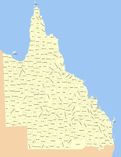
Lands administrative divisions of Queensland refers to the divisions of Queensland used for the registration of land titles. There are 322 counties, and 5,319 parishes within the state. They are part of the Lands administrative divisions of Australia. Queensland had been divided into 109 counties in the nineteenth century, before the Land Act of 1897 subdivided many of these counties to 319. Some of the eastern counties remained the same, with most of the subdivisions occurring in the west and north. The current counties were named and bounded by the Governor in Council on 7 March 1901.

County of Nares Cadastral in Queensland, Australia

The county of Nares is a cadastral division of Queensland which contains the city of Cairns, Innisfail and most of the Atherton Tableland. It was named after George Nares (1831–1915), a naval officer and commander of HMS Salamander. Cairns is mentioned as being in the county of Nares in the 1911 Britannica. It is bounded by the Daintree River in the north.

Cărpinet Commune in Bihor County, Romania

Cărpinet is a commune in Bihor County, northwestern Romania with a population of 2,174 people. It is composed of four villages: Călugări (Kalugyer), Cărpinet, Izbuc (Vaskohszohodol) and Leheceni (Lehecsény).

Bierzewice Village in Masovian, Poland

Bierzewice is a village in the administrative district of Gmina Gostynin, within Gostynin County, Masovian Voivodeship, in east-central Poland. It lies approximately 4 kilometres (2 mi) north of Gostynin and 107 km (66 mi) west of Warsaw.

Cape Grafton headland in Queensland, Australia

Cape Grafton is a cape located to the north-east of Cairns in Queensland, Australia. The cape was named by Lieutenant James Cook during his first voyage of discovery in 1770. It was named after Augustus FitzRoy, 3rd Duke of Grafton, the British prime minister when Cook sailed. Cook set anchor two miles from the shore and briefly inspected the cape with botanists Joseph Banks and Daniel Solander.

The McDonnell XHJH Whirlaway was a 1940s American experimental twin-rotor helicopter designed and built by McDonnell Aircraft for the United States Navy. It was the first successful twin-engined, twin rotor helicopter in the world. The Whirlaway was the largest helicopter flown up to that time.

Kupu is a village in Kuusalu Parish, Harju County in northern Estonia.

Tõrise is a village in Saaremaa Parish, Saare County in western Estonia.

Danbulla National Park and State Forest Protected area in Queensland, Australia

Danbulla National Park and State Forest is a national park and state forest complex in Queensland, Australia, around 60 km west of Cairns.

County of Dagmar Cadastral in Queensland, Australia

The county of Dagmar is a cadastral division of Queensland north-west of Cairns. It contains the town of Julatten.

<i>Lithomyrtus obtusa</i> species of plant

Lithomyrtus obtusa, commonly known as beach myrtella, is a flowering plant species in the myrtle family, Myrtaceae. It occurs in coastal areas in New Guinea and Queensland, Australia.

Bloomfield, Queensland Suburb of Shire of Cook, Queensland, Australia

Bloomfield is a town in the Shire of Cook and a coastal locality which is split between the Shire of Cook and the Shire of Douglas in Queensland, Australia. In the 2011 census, Bloomfield had a population of 403 people. The neighbourhood of Ayton is within the locality.

Wangetti, Queensland Town in Queensland, Australia

Wangetti is a coastal town and a locality in the Shire of Douglas, Queensland, Australia. In the 2016 census, Wangetti had a population of 50 people.

Macalister Range National Park is a protected area of Queensland in Australia. It is within the locality of Wangetti in the Shire of Douglas and within the Macalister Range locality in the Cairns Region and forms part of the Wet Tropics World Heritage Area.

References

  1. "Solander - county (entry 31356)". Queensland Place Names. Queensland Government . Retrieved 21 June 2017.
  2. Cook District, County of Solander Maps - Q4 Series at Queensland Archives.

Coordinates: 16°29′S145°27′E / 16.483°S 145.450°E / -16.483; 145.450

Geographic coordinate system Coordinate system

A geographic coordinate system is a coordinate system that enables every location on Earth to be specified by a set of numbers, letters or symbols. The coordinates are often chosen such that one of the numbers represents a vertical position and two or three of the numbers represent a horizontal position; alternatively, a geographic position may be expressed in a combined three-dimensional Cartesian vector. A common choice of coordinates is latitude, longitude and elevation. To specify a location on a plane requires a map projection.