The Eastern Continental Divide or Eastern Divide or Appalachian Divide is a hydrographic divide in eastern North America that separates the easterly Atlantic Seaboard watershed from the westerly Gulf of Mexico watershed. The divide nearly spans the United States from south of Lake Ontario through the Florida peninsula, and consists of raised terrain including the Appalachian Mountains to the north, the southern Piedmont Plateau and lowland ridges in the Atlantic Coastal Plain to the south. Water including rainfall and snowfall, lakes, streams and rivers on the eastern/southern side of the divide drains to the Atlantic Ocean; water on the western/northern side of the divide drains to the Gulf of Mexico. The ECD is one of six continental hydrographic divides of North America which define several drainage basins, each of which drains to a particular body of water.

The Line of Property is the name commonly given to the line dividing Indian from British Colonial lands established in the 1768 Treaty of Fort Stanwix between the British officials and the Indian tribes. In western Pennsylvania it is referred to as the Purchase line.

The County of Stanley is a cadastral division centred on the city of Brisbane in Queensland, Australia, that is used mainly for the purpose of registering land titles. It was named after Edward Stanley, who was three times British prime minister in the 1850s and 1860s. It is bounded by the Logan River in the south, the Brisbane River at what is now Lake Wivenhoe in the west, the Stanley River at what is now Lake Somerset in the north-west, and Caboolture River in the north. It includes Moreton Island and Stradbroke Island, and extends west to Ipswich's CBD, south to Loganlea and north to Morayfield.
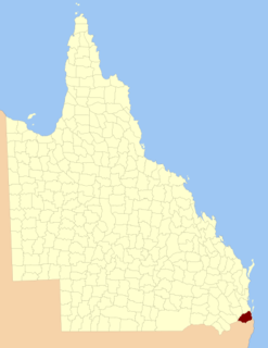
The County of Ward is a county in the south-eastern corner of Queensland, Australia. The main urban area within the county is the city of the Gold Coast, and it also extends to include the southern parts of the West Moreton region centred on Beaudesert and Boonah.

The County of Canning is a county in Queensland, Australia. The county consists of almost all of the former Shires of Caboolture, Maroochy and Kilcoy and the former City of Caloundra. Its main urbanised areas are centred on the Sunshine Coast and the areas surrounding Caboolture.

The Georgina River is the north-westernmost of the three major rivers of the Channel Country in Central West Queensland, that also flows through a portion of the Northern Territory, in central Australia. Part of the Lake Eyre basin, the Georgina flows in extremely wet years into Lake Eyre.

The Maroochy River is a river in South East Queensland, Australia. The river rises from the eastern slopes of the Blackall Range and flows east through Eumundi, before entering the sea at Cotton Tree, Maroochydore. Other populated centres in the catchment include Nambour, Eudlo, Yandina and Coolum.

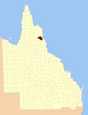
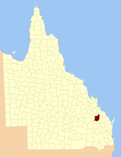
Wicklow County is a county in Queensland, Australia, located in the Wide Bay–Burnett region. On 7 March 1901, the Governor issued a proclamation legally dividing Queensland into counties under the Land Act 1897. Its schedule described Wicklow thus:
Bounded on the east by the county of Yarrol; on the south by the county of Newcastle; on the west by the eastern watershed of the Dawson River; and on the north by the south boundaries of Knockbreak Lease, Calrossie Resumption, Culcragie Lease, part of Culcragie Resumption, and by the north boundary of Eidsvold Resumption.

The County of March is a county in Queensland, Australia. The county consists of the Noosa area, plus the eastern parts of the Gympie and Fraser Coast regions.
The County of Carlisle is a county in Queensland, Australia. The county is centred on the city of Mackay and includes most of the Mackay Region. It takes its name from Carlisle in England.

The County of Rochedale is a county in Queensland, Australia. It is centred on the city of Mount Isa, its only population centre. On 7 March 1901, the Governor issued a proclamation legally dividing Queensland into counties under the Land Act 1897. Its schedule described Rochedale thus:
Bounded on the north by the county of Brahe and parts of the west and south of Glenvale No. 2 Block to the Leichhardt River, by that river upwards to the north-west corner of Parkside No. 1, by the north, east and south boundaries of that block, part of the south and east boundaries of Parkside No. 2, part of the north, the east, and south boundaries of Parkside No. 5, and the east boundary of Parkside No. 8 Block; on the south by the counties of Chapworth, Waverley and Piturie; and on the west by the county of Nash.
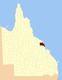
The County of Clinton is a county in Queensland, Australia. It is centred on the city of Gladstone and includes most of the Gladstone Region. The county was created on 1 September 1855 by royal proclamation under the Waste Lands Australia Act 1846. On 7 March 1901, the Governor issued a proclamation legally dividing Queensland into counties under the Land Act 1897. Its schedule described Clinton thus:
Bounded on the south by the county of Yarrol; on the west by the county of Rawbelle and the eastern watershed of Callide Creek and the Don River; on the north by the northern watershed of the Calliope River; and on the east by the Pacific Ocean and the county of Flinders.
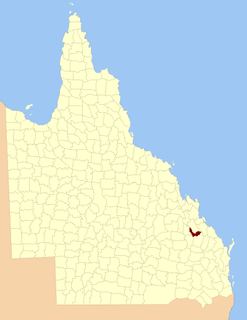
The County of Pelham is a county in Queensland, Australia, located in the Shire of Banana in Central Queensland. The county was created on 1 September 1855 by royal proclamation under the Waste Lands Australia Act 1846. On 7 March 1901, the Governor issued a proclamation legally dividing Queensland into counties under the Land Act 1897. Its schedule described Pelham thus:
Bounded on the north by the county of Raglan; on the east by the counties of Clinton and Rawbelle; on the south by the county of Rawbelle and the southern watershed of Scoria and Prospect Creeks; and on the west by the eastern watershed of the Dawson River.
The County of Yarrol is a county in Queensland, Australia, located in the Wide Bay–Burnett region to the west of Bundaberg. On 7 March 1901, the Governor issued a proclamation legally dividing Queensland into counties under the Land Act 1897. Its schedule described Yarrol thus:
Bounded on the east by the county of Bowen; on the south and west by the Burnett River upwards to the western watershed of Three Moon Creek, by that watershed northerly to the southern watershed of Glassford Creek; and on the north by the southern boundary of the parish of Bompa.
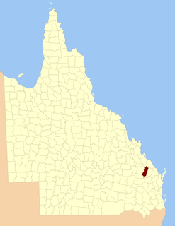
The County of Rawbelle is a county in Queensland, Australia, located in the Wide Bay–Burnett region. On 7 March 1901, the Governor issued a proclamation legally dividing Queensland into counties under the Land Act 1897. Its schedule described Rawbelle thus:
Bounded on the south by the county of Wicklow; on the west by the eastern watershed of the Dawson River; on the north by the northern watersheds of Rawbelle River and Three Moon Creek; and on the east by the county of Yarrol.

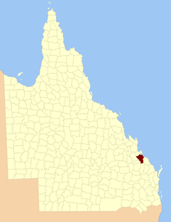
The County of Flinders is a county in Queensland, Australia, located in the Central Queensland region between Gladstone and Bundaberg. It was named for Matthew Flinders who explored the Australian coastline.

The County of Newcastle is a county in the Wide Bay–Burnett region of Queensland, Australia. On 7 March 1901, the Governor issued a proclamation legally dividing Queensland into counties under the Land Act 1897. Its schedule described Newcastle thus:
Bounded on the east by the counties of Mackenzie and Boondooma; on the south by the Main Dividing Range; on the west by the eastern watershed of the Dawson River; on the north by the northern boundaries of the leased parts of Auburn and Hawkwood Runs and the Auburn River from the confluence of Narayen Creek downwards to its junction with the Burnett River.

The Kedron Division is a former local government area of Queensland, Australia, located in northern Brisbane.

Tara Station is a locality in the Barcaldine Region, Queensland, Australia. In the 2016 census, Tara Station had a population of 10 people.