Tianjin, a municipality in China, is also spelled Tientsin.

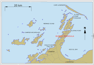
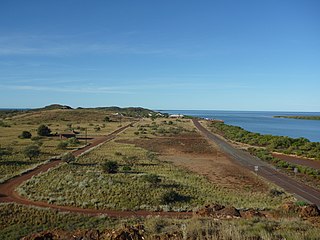
Dampier is a major industrial port in the Pilbara region in the northwest of Western Australia. It is located near the city of Karratha and Port Walcott.
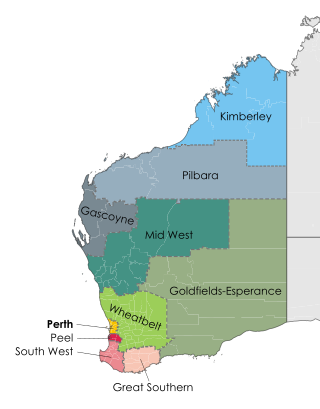
The Pilbara is a large, dry, thinly populated region in the north of Western Australia. It is known for its Aboriginal peoples; its ancient landscapes; the red earth; and its vast mineral deposits, in particular iron ore. It is also a global biodiversity hotspot for subterranean fauna.

Port Hedland is the second largest town in the Pilbara region of Western Australia, with an urban population of 14,320 at June 2018 including the satellite town of South Hedland, 18 kilometres (11 mi) away. It is also the site of the highest tonnage port in Australia.
Karratha is a city in the Pilbara region of Western Australia, adjoining the port of Dampier. It was established in 1968 to accommodate the processing and exportation workforce of the Hamersley Iron mining company and, in the 1980s, the petroleum and liquefied natural gas operations of the North West Shelf Venture. As of June 2018, Karratha had an urban population of 16,708. The city's name comes from the cattle station of the same name, which derives from a word in a local Aboriginal language meaning "good country" or "soft earth". The city is the seat of government of the City of Karratha, a local government area covering the surrounding region.

Cossack, formerly known as Tien Tsin, is an historic ghost town located 1,480 km (920 mi) north of Perth and 15 km (9.3 mi) from Roebourne in the Pilbara region of Western Australia. The nearest town to Cossack, which is located on Butcher Inlet at the mouth of the Harding River, is Wickham. The former Tien Tsin Harbour is now known as Port Walcott.

Pearling in Western Australia includes the harvesting and farming of both pearls and pearl shells along the north-western coast of Western Australia.

Pilbara newspapers is a selection of newspapers published in the Pilbara region of Western Australia.
Western Australia has the longest coastline of any state or territory in Australia, at 10,194 km or 12,889 km. It is a significant portion of the coastline of Australia, which is 35,877 km.
Cape Lambert is a port facility operated by Rio Tinto Iron Ore in the Pilbara region of Western Australia. It is located 40 kilometres north of Karratha.

Iron ore mining in Western Australia, in the 2018–19 financial year, accounted for 54 percent of the total value of the state's resource production, with a value of A$78.2 billion. The overall value of the minerals and petroleum industry in Western Australia was A$145 billion in 2018-19, a 26 percent increase on the previous financial year.

Robert John Sholl was a government administrator, magistrate, explorer, journalist, entrepreneur, harbourmaster, customs official, postmaster and lay reader in Western Australia (WA), during the colonial era. Because of his multiple, simultaneous roles, which carried judicial, political, cultural and commercial power and influence, Sholl is regarded as a significant figure in the history of North-West Australia, at an early stage of its settlement by Europeans.

Port Hedland is one of the largest iron ore loading ports in the world and the largest in Australia. In 2011 it had the largest bulk cargo throughput in Australia. With the neighboring ports of Port Walcott and Dampier, Port Hedland is one of three major iron ore exporting ports in the Pilbara region of Western Australia,
Peter Hedland originally Lars Peter Hedlund, 14 March 1829 – 1881, was a significant figure in European settlement in North-West Australia. A mariner, explorer, and pearler; he was widely known as "Captain Hedland". Some contemporary accounts and some of Hedland's descendants have spelt the surname Headland, although it is not clear that he ever used this spelling.
Mount Welcome Station is a pastoral lease that once operated as a sheep station but is now operated as a cattle station in Western Australia.
The Railways in the Pilbara are a collection of railways in the Pilbara region of north-west Western Australia.
Main Roads Western Australia controls the major roads in the state's Pilbara region. There are two main highways in the region: Great Northern Highway, which travels north through the region to Port Hedland and then north-west along the coast, as well as North West Coastal Highway, which heads south-west from Port Hedland. A series of main roads connects towns to the highways, and local roads provide additional links. The majority of these roads service the western half of the region, with few located in the various deserts east of the Oakover River. Roads are often named after the towns or areas they connect.
Anketell Port, also known as Port Robinson, is a natural harbour in the Pilbara region of Western Australia (WA). The port is 10 kilometres (6.2 mi) west of Cape Lambert and 30 kilometres (19 mi) east of Karratha.

The Pilbara Coast is the coastline of Western Australia's Pilbara region. It is often referred to as the North West Coast of Western Australia.
Condon, officially gazetted as Shellborough, is a former settlement and port in the Pilbara region of Western Australia. Originating as an unofficial pearlers' camp in the late 1860s, the town was abandoned some time around 1930. Located on Condon Creek, the former townsite is 15 km east of the mouth of the De Grey River and 86 km east of Port Hedland; it is in the Shire of Port Hedland.


