This page is based on this
Wikipedia article Text is available under the
CC BY-SA 4.0 license; additional terms may apply.
Images, videos and audio are available under their respective licenses.
Indian or Indians refers to people or things related to India, or to the indigenous people of the Americas, or Aboriginal Australians until the 19th century.

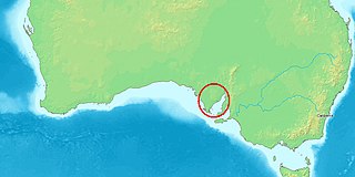
The Spencer Gulf is the westernmost of two large inlets on the southern coast of Australia, in the state of South Australia, facing the Great Australian Bight. It spans from the Cape Catastrophe and Eyre Peninsula in the west to Cape Spencer and Yorke Peninsula in the east.

In geography, a sound is a large sea or ocean inlet, deeper than a bight and wider than a fjord; or a narrow sea or ocean channel between two bodies of land.

Asia-Pacific or Asia Pacific is the part of the world in or near the Western Pacific Ocean. The region varies in area depending on which context, but it typically includes much of East Asia, South Asia, Southeast Asia, and Oceania.

The states and territories are the first-level administrative divisions of the Commonwealth of Australia. They are the second level of government in Australia, located between the federal and local government tiers.

There are seven sovereign states who currently maintain de jure, largely symbolic territorial claims in Antarctica: Argentina, Australia, Chile, France, New Zealand, Norway and the United Kingdom. These countries have tended to place their Antarctic scientific observation and study facilities within their respective claimed territories; however, a number of such facilities are located nowhere near the sectors claimed by their respective countries of operation, and there are multiple other countries such as Russia and the United States who, despite having no territorial claim of their own anywhere in Antarctica, have constructed large research facilities within the sectors claimed by other countries.

Port Spencer was a proposed bulk commodities port development project in South Australia, previously known as Sheep Hill. It would have been located on lower Eyre Peninsula, on the western shore of Spencer Gulf. The project was conceived by Centrex Metals Ltd for the export of iron ore from prospective iron ore deposits at Wilgerup and in the hills of Koppio on Lower Eyre Peninsula. The port project was also dependent on the approval of the Fusion Magnetite Project, which was a joint venture partnership between Centrex Metals Ltd and Wuhan Iron & Steel (Group) Co, a Chinese government steelmaking enterprise. Pending mine and port project environmental approvals and adequate capital investment, the port would have been built by Centrex Metals Ltd. In October 2016 the joint venture was wound up. In September 2018, agribusiness Free Eyre expressed interest in revisiting and optimising previous plans for Port Spencer exclusively for the export of grain.

Captain Thomas Lipson was an officer in the Royal Navy, who, after a successful if unspectacular career in the Royal Navy, was appointed by the Admiralty as the first Harbour Master at South Australia, arriving there with the pioneer settlers. Serving from 1836 to 1855, based at Port Adelaide, Lipson also superintended many of the initial maritime surveys of that new colony.
Lipson & Kaad was an Australian architectural practice working in Sydney, New South Wales from the 1930s until the 1960s. The partners were Samuel Lipson (1901–1995) and Peter Kaad (1898–1967). In Migrant architects practising modern architecture Rebecca Hawcroft states that "the firm became one of the most successful and prominent in the period and designed several of the era’s best buildings". Both partners were influence by the Amsterdam School and in particular the work of Willem Dudok.

Pullen Island is a 1 ha granite island lying 0.5 km offshore from the town of Port Elliot on the southern coast of the Fleurieu Peninsula of South Australia. It was originally named Lipson Island but was renamed in 1839 by W.J.S. Pullen, the Colonial Marine Surveyor, after himself. The island is protected by designation as the Pullen Island Conservation Park.

Cape Hardy is a 20 m (66 ft) high, dune-capped granite headland on the eastern coast of Eyre Peninsula and which protrudes into Spencer Gulf in South Australia. It is located between the towns of Port Neill and Tumby Bay, 10 km (6.2 mi) north-northeast of Lipson Cove.

Williams Island is an island in the Australian state of South Australia located off the south coast of Jussieu Peninsula on Eyre Peninsula approximately 34 km (21 mi) south-east of Port Lincoln. It was named by Matthew Flinders for Robert Williams who subsequently lost his life along with seven other crew in the capsize of a cutter launched from HM Sloop Investigator to search for water on 21 February 1802. Since 2004, the island has been part of the Memory Cove Wilderness Protection Area.

Cape St Albans is a headland in the Australian state of South Australia located on the north coast of the Dudley Peninsula on Kangaroo Island in the gazetted locality of Willoughby about 18 kilometres south-east of the town of Penneshaw.

Western Kangaroo Island Marine Park is a marine protected area located south of South Australia in waters within the Australian Exclusive economic zone to the south-west of Kangaroo Island and ranging in depth from 15 metres to 165 metres.

Western Kangaroo Island Marine Park is a marine protected area in the Australian state of South Australia located in the state’s coastal waters adjoining both the west coast of Kangaroo Island and Lipson Reef, an islet located to the south of Kangaroo Island.

The Red Cross House is a heritage-listed former commercial building and now Australian Red Cross and blood transfusion centre located at 153-159 Clarence Street, in the Sydney central business district, in the City of Sydney local government area of New South Wales, Australia. It was designed by Samuel Lipson, architect, in conjunction with Robertson and Marks and McCredie and built from 1937 to 1938 by Kell and Rigby. It was originally built for the firm of S. Hoffnung & Co.. The property is owned by the Australian Red Cross - NSW Division. It was added to the New South Wales State Heritage Register on 25 May 2001.


