
Project Plowshare was the overall United States program for the development of techniques to use nuclear explosives for peaceful construction purposes. The program was organized in June 1957 as part of the worldwide Atoms for Peace efforts. As part of the program, 31 nuclear warheads were detonated in 27 separate tests. A similar program was carried out in the Soviet Union under the name Nuclear Explosions for the National Economy.
Nuclear weapons tests are experiments carried out to determine nuclear weapons' effectiveness, yield, and explosive capability. Testing nuclear weapons offers practical information about how the weapons function, how detonations are affected by different conditions, and how personnel, structures, and equipment are affected when subjected to nuclear explosions. However, nuclear testing has often been used as an indicator of scientific and military strength. Many tests have been overtly political in their intention; most nuclear weapons states publicly declared their nuclear status through a nuclear test.

The Gunbarrel Highway is an isolated desert track in the Northern Territory, South Australia and Western Australia. It consists of about 1,350 km (840 mi) of washaways, heavy corrugations, stone, sand and flood plains. The Gunbarrel Highway connects Victory Downs in the Northern Territory to Carnegie Station in Western Australia. Some sources incorrectly show the highway extending west to Wiluna. The road was built as part of Australia's role in the weapons research establishment called Woomera which included Emu Field and Maralinga, both atomic bomb testing sites. The name comes from Len Beadell's Gunbarrel Road Construction Party so named as his intention was to build roads as straight as a gunbarrel.

Leonard Beadell OAM BEM FIEMS was a surveyor, road builder, bushman, artist and author, responsible for constructing over 6,000 km (3,700 mi) of roads and opening up isolated desert areas – some 2.5 million square kilometres – of central Australia from 1947 to 1963. Born in West Pennant Hills, New South Wales, Beadell is sometimes called "the last true Australian explorer".

Woomera, unofficially Woomera village, refers to the domestic area of RAAF Base Woomera. Woomera village has always been a Defence-owned and operated facility. The village is located on the traditional lands of the Kokatha people in the Far North region of South Australia, but is on Commonwealth-owned land and within the area designated as the 'Woomera Prohibited Area' (WPA). The village is approximately 446 kilometres (277 mi) north of Adelaide. In common usage, "Woomera" refers to the wider RAAF Woomera Range Complex (WRC), a large Australian Defence Force aerospace and systems testing range covering an area of approximately 122,000 square kilometres (47,000 sq mi) and is operated by the Royal Australian Air Force.
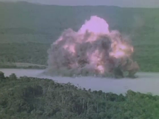
Operation Blowdown was an explosives test carried out in the Kutini-Payamu jungle of Australia's Cape York Peninsula in 1963, to simulate the effects of a nuclear weapon on tropical rainforest. It was conducted by the Australian Army, the Department of Supply, and the Defence Standards Laboratory with participation from the United Kingdom, Canada and United States. In addition, blast effects on military material, field fortifications, supply points, and foot and vehicle movement were examined in a rain forest environment.
Operation Hardtack I was a series of 35 nuclear tests conducted by the United States from April 28 to August 18 in 1958 at the Pacific Proving Grounds. At the time of testing, the Operation Hardtack I test series included more nuclear detonations than the total of prior nuclear explosions in the Pacific Ocean. These tests followed the Project 58/58A series, which occurred from 1957 December 6 to 1958, March 14, and preceded the Operation Argus series, which took place in 1958 from August 27 to September 6.

Maralinga, in the remote western areas of South Australia, was the site, measuring about 3,300 square kilometres (1,300 sq mi) in area, of British nuclear tests in the mid-1950s.

Anne Beadell Highway is an outback unsealed track linking Coober Pedy, South Australia, and Laverton, Western Australia, a total distance of 1,325 km (823 mi). The track was surveyed and built by Len Beadell, Australian surveyor, who named it after his wife. The track passes through remote arid deserts and scrub territory of South Australia and Western Australia, which often have summer temperatures approaching 50 °C (122 °F). Sand dunes predominate for most of the track.
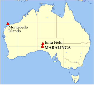
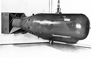
Between 1956 and 1963, the United Kingdom conducted seven nuclear tests at the Maralinga site in South Australia, part of the Woomera Prohibited Area about 800 kilometres (500 mi) north west of Adelaide. Two major test series were conducted: Operation Buffalo in 1956 and Operation Antler the following year. Approximate weapon yields ranged from 1 to 27 kilotons of TNT. The Maralinga site was also used for minor trials, tests of nuclear weapons components not involving nuclear explosions. Kittens were trials of neutron initiators; Rats and Tims measured how the fissile core of a nuclear weapon was compressed by the high explosive shock wave; and Vixens investigated the effects of fire or non-nuclear explosions on atomic weapons. The minor trials, numbering around 550, ultimately generated far more contamination than the major tests.
RAAF Base Woomera (WMA), was proclaimed by Chief of Air Force Directive in January 2015. RAAF Base Woomera and the RAAF Woomera Test Range (WTR) are the two formations which make up the RAAF Woomera Range Complex (WRC). RAAF Base Woomera consists of two sectors, 'Base Sector North' which is a restricted access area and includes Camp Rapier. the entrance to the Woomera Test Range and the RAAF Woomera Airfield. 'Base Sector South' is accessible by the public and essentially encompasses that part of RAAF Base Woomera long referred to as the Woomera Village. Woomera Village is often quoted as a 'remote town'. It is not a 'town', but rather an 'open base' of the RAAF. The 'village' has previously always functioned as an Australian Government/Defence Force garrison facility until it was fully incorporated into RAAF Base Woomera in 2015.
A nuclear explosion is an explosion that occurs as a result of the rapid release of energy from a high-speed nuclear reaction. The driving reaction may be nuclear fission or nuclear fusion or a multi-stage cascading combination of the two, though to date all fusion-based weapons have used a fission device to initiate fusion, and a pure fusion weapon remains a hypothetical device. Nuclear explosions are used in nuclear weapons and nuclear testing.
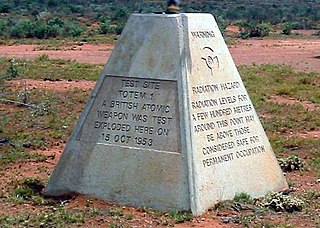
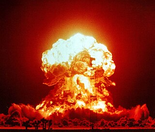
Operation Totem was a pair of British atmospheric nuclear tests which took place at Emu Field in South Australia in October 1953. They followed the Operation Hurricane test of the first British atomic bomb, which had taken place at the Montebello Islands a year previously. The main purpose of the trial was to determine the acceptable limit on the amount of plutonium-240 which could be present in a bomb.
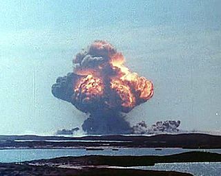
Operation Mosaic was a series of two British nuclear tests conducted in the Monte Bello Islands in Western Australia on 16 May and 19 June 1956. These tests followed the Operation Totem series and preceded the Operation Buffalo series. The second test in the series was the largest ever conducted in Australia.

Frenchman Flat is a hydrographic basin in the Nevada National Security Site south of Yucca Flat and north of Mercury, Nevada. The flat was used as an American nuclear test site and has a 5.8 sq mi (15 km2) dry lake bed that was used as a 1950s airstrip before it was chosen after the start of the Korean War for the Nevada Proving Grounds. Nellis Air Force Base land 12 mi × 30 mi was transferred to the Atomic Energy Commission on which Site Mercury was constructed on the flat for supporting American nuclear explosive tests. The 1951 Operation Ranger "Able" test was the first continental US nuclear detonation after the 1945 Trinity test, and Frenchman Flat also had the only detonation of an American artillery-fired nuclear projectile in the 1953 Upshot-Knothole Grable test using the M65 Atomic Cannon.
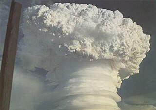
The United Kingdom conducted 12 major nuclear weapons tests in Australia between 1952 and 1957. These explosions occurred at the Montebello Islands, Emu Field and Maralinga.

Mount Davies Road is a remote unsealed outback track which runs from Mount Davies (Pipalyatjara) in the far north-west corner of South Australia to Anne's Corner on the Anne Beadell Highway 397 kilometres to the south-east. It was built during 1956 and 1957 by the Gunbarrel Road Construction Party (GRCP) surveyed and led by Len Beadell for the Weapons Research Establishment at Woomera, South Australia.

The RAAF Woomera Range Complex (WRC) is a major Australian military and civil aerospace facility and operation located in South Australia, approximately 450 km (280 mi) north-west of Adelaide. The WRC is operated by the Royal Australian Air Force (RAAF), a division of the Australian Defence Force (ADF). The complex has a land area of 122,188 km2 (47,177 sq mi) or roughly the size of North Korea or Pennsylvania. The airspace above the area is restricted and controlled by the RAAF for safety and security. The WRC is a highly specialised ADF test and evaluation capability operated by the RAAF for the purposes of testing defence materiel.
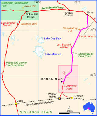
Maralinga to Emu Road is a remote unsealed outback track that links Maralinga to Emu in the western region of South Australia. It was built by Len Beadell for the Weapons Research Establishment of Salisbury, South Australia in 1955.

