
Eyre Highway is a 1,664-kilometre (1,034 mi) highway linking Western Australia and South Australia via the Nullarbor Plain. Signed as National Highways 1 and A1, it forms part of Highway 1 and the Australian National Highway network linking Perth and Adelaide. It was named after explorer Edward John Eyre, who was the first European to cross the Nullarbor by land, in 1840–1841. Eyre Highway runs from Norseman in Western Australia, past Eucla, to the state border. Continuing to the South Australian town of Ceduna, it crosses the top of the Eyre Peninsula before reaching Port Augusta.

Norseman is a town located in the Goldfields-Esperance region of Western Australia along the Coolgardie-Esperance Highway, 726 kilometres (451 mi) east of Perth and 278 metres (912 ft) above sea level. It is also the starting point of the Eyre Highway, and the last major town in Western Australia before the South Australian border 720 kilometres (447 mi) to the east. At the 2021 census, Norseman had a population of 562, of which 17% were Australian Aboriginal.

Eucla is the easternmost locality in Western Australia, located in the Goldfields-Esperance region of Western Australia along the Eyre Highway, approximately 11 kilometres (7 mi) west of the South Australian border. At the 2016 Australian census, Eucla had a population of 53.

Ooldea, known as Yuldea and various other names by Western Desert peoples (Aṉangu), is a tiny settlement in South Australia. It is on the eastern edge of the Nullarbor Plain, 863 km (536 mi) west of Port Augusta on the Trans-Australian Railway. Ooldea is 143 km (89 mi) from the bitumen Eyre Highway.
Caiguna is a small roadhouse community located on the Eyre Highway in Western Australia. It is the second stop east of Norseman on the journey east across the Nullarbor Plain. Between Balladonia and Caiguna is a 146.6-kilometre (91.1 mi) stretch of the highway which is one of the longest straight stretches of road in the world. The unofficial Central Western Time (CWT) starts shortly east of Caiguna, heading eastward.

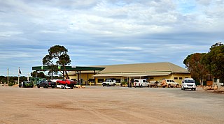
Cocklebiddy is a small roadhouse community located on the Eyre Highway in Western Australia. It is the third stop after Norseman on the journey eastwards across the Nullarbor Plain. Like other locations in the region, the site consists of little more than a roadhouse. The current business name of the roadhouse is the Wedgetail Inn and, like most other Nullarbor establishments, has access to satellite television, as well as providing caravan park and hotel-motel facilities.
Lameroo is a town in the Murray Mallee region of South Australia. It is on the Mallee Highway and Pinnaroo railway line about 40 km west of the Victorian border, or 210 km east of Adelaide. It is primarily a service town for the surrounding rural areas, growing grain and sheep. Lameroo now includes the former settlements of Kulkami, Mulpata, Wirha and Gurrai, which were on the Peebinga railway line, and Wilkawatt, which was between Parrakie and Lameroo on the Pinnaroo railway.

Innamincka, formerly Hopetoun, is a township and locality in north-east South Australia. By air it is 820 kilometres north-east of the state capital, Adelaide, and 365 kilometres north-east of the closest town, Lyndhurst. It is 66 kilometres north-east of the Moomba Gas Refinery. The town lies within the Innamincka Regional Reserve and is surrounded by the Strzelecki Desert to the south and the Sturt Stony Desert to the north. It is linked by road to Lyndhurst via the Strzelecki Track, to the Birdsville Developmental Road via Cordillo Downs Road and Arrabury Road, and the Walkers Crossing Track to the Birdsville Track. The Walkers Crossing Track is closed in summer and only traversable in dry weather. The township is situated along the Cooper Creek, a part of the Lake Eyre basin.

nat

Madura is a small roadhouse community located on the Eyre Highway in Western Australia, on the Roe Plains. It is 1,253 kilometres (779 mi) from Perth. It is at the foot of the escarpment next to the Madura Pass down from the Nullarbor Plain. UTC+8:45 is the local time zone in use.

The Outback Communities Authority (OCA) is a statutory authority in South Australia (SA) created under the Outback Communities Act 2009. It has been established to "manage the provision of public services and facilities to outback communities" which are widely dispersed across the Pastoral Unincorporated Area which covers almost 60% of South Australia's land area. The authority has its seat at both Port Augusta which is located outside the unincorporated area and at Andamooka. The authority serves an area of 624,339 square kilometres, slightly smaller than France. The area has a population of 3,750, of whom 639 are Indigenous Australians, and includes several large pastoral leases and mining operations.
Kingoonya, originally spelt Kingoonyah, pronounced, was a small settlement, or township, now almost totally abandoned, in the central outback of the Australian state of South Australia. It was established in 1916 as a railway settlement on the Trans-Australian Railway, mainly to provide refuelling for steam trains and track maintenance services; it also served about 200 families living on sheep grazing properties in the region.

Nullarbor is a locality in the Australian state of South Australia located 295 kilometres (183 mi) to the west of the town of Ceduna in the western part of the state immediately adjoining the border with Western Australia.
Fowlers Bay, formerly known as Yalata, is a bay, town and locality in the Australian state of South Australia located about 658 kilometres (409 mi) north-west of the state capital, Adelaide. The town is located on Port Eyre, at the western end of the larger Fowlers Bay. It was named Yalata after Yalata station, established in the 1860s and stretching from the Nullarbor Plain across to near Streaky Bay on the Eyre Peninsula, whose homestead was located on the hill nearby. The name Yalata now belongs to a small Aboriginal community further west, which was also situated on station land.

Nundroo is a small South Australian town, located approximately 1,014 kilometres (630 mi) west of Adelaide. It is a popular rest stop for travellers due to its location on the Eyre Highway.

Penong is a town and locality on the Nullarbor Plain, in the far west of the state of South Australia located about 616 kilometres (383 mi) north-west of the state capital of Adelaide. With no settlements between it and Border Village on the border with Western Australia, 400 km (250 mi) away on the Eyre Highway, it is a popular rest-stop for travellers.
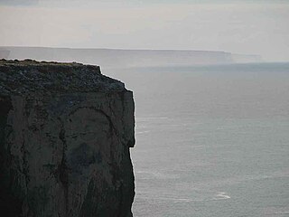
The Bunda Cliffs, also known as the Nullarbor Cliffs, are a coastal scarp on the southern coast of Australia, extending from the western coast of South Australia to the south-eastern corner of Western Australia.
Coorabie is a town and locality in the Australian state of South Australia located about 675 kilometres (419 mi) north-west of the state capital of Adelaide. It is outside of district council boundaries, and therefore managed by the Outback Communities Authority. It is located in the west of South Australia, and includes the Wahgunyah Conservation Park. The Eyre Highway passes through the locality, although the Coorabie township is south of the highway.
In South Australia, one of the states of Australia, there are many areas which are commonly known by regional names. Regions are areas that share similar characteristics. These characteristics may be natural such as the Murray River, the coastline, desert or mountains. Alternatively, the characteristics may be cultural, such as common land use. South Australia is divided by numerous sets of regional boundaries, based on different characteristics. In many cases boundaries defined by different agencies are coterminous.
Allandale Station is a locality in the Australian state of South Australia located about 848 kilometres (527 mi) north of the state capital of Adelaide and about 20 kilometres (12 mi) south-east of the town of Oodnadatta.

