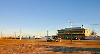
The township adjacent to Leigh Creek Railway Station was officially dedicated as the Town of Copley by a proclamation published on 27 August 1891.[2] The name honours William Copley, who at the time the town was proclaimed was a member of the Legislative Council for the Northern District.[9]
According to Rodney Cockburn (in his Nomenclature of South Australia) the name Leigh Creek for the railway station and post office "was officially abandoned in 1916 on the advice of the Nomenclature Committee, who acted upon the suggestion of Lachlan McTaggart of Wooltana Station The Committee pointed out that it was most undesirable to have a town of one designation and a railway station and post office of another. The name Leigh Creek had no legal status by way of dedication, while the town of Copley was proclaimed under the Crown Lands Act and there were many sound reasons why the latter appellative should be adopted for all Government purposes. It seemed absurd to have a name wholly foreign to the title deeds used for the post office and railway station. At a public meeting the residents protested vigorously against the change.[10]
↑ "Placename Details: Copley". Property Location Browser. Government of South Australia. 6 May 2013. SA0016021. Archived from the original on 12 October 2016. Retrieved 27 August 2015.
↑ "Country News". Chronicle. 5 May 1917. Retrieved 26 June 2023.
↑ "Copley". Outback Communities Authority. Archived from the original on 19 March 2016. Retrieved 19 May 2016.
Sources
Extract entitled "Copley, A Potted History" Commemorating Copley's Centenary 1891–1991. On one side is a map, Portion D.BP.10, Roads Book
Marree is a small town located in the north of South Australia. It is located 589 kilometres (366 mi) North of Adelaide at the junction of the Oodnadatta Track and the Birdsville Track, 49 metres (161 ft) above sea level. Marree is an important service centre for the large sheep and cattle stations in northeast South Australia as well as a stopover destination for tourists traveling along the Birdsville or Oodnadatta Tracks.
Leigh Creek is a former coal-mining town in eastern central South Australia. At the 2016 census, Leigh Creek had a population of 245, a 55% decrease from 550 in the previous census in 2011.
Innamincka, formerly Hopetoun, is a township and locality in north-east South Australia. By air it is 820 kilometres north-east of the state capital, Adelaide, and 365 kilometres north-east of the closest town, Lyndhurst. It is 66 kilometres north-east of the Moomba Gas Refinery. The town lies within the Innamincka Regional Reserve and is surrounded by the Strzelecki Desert to the south and the Sturt Stony Desert to the north. It is linked by road to Lyndhurst via the Strzelecki Track, to the Birdsville Developmental Road via Cordillo Downs Road and Arrabury Road, and the Walkers Crossing Track to the Birdsville Track. The Walkers Crossing Track is closed in summer and only traversable in dry weather. The township is situated along the Cooper Creek, a part of the Lake Eyre basin.
Lyndhurst is a town in north-east South Australia which is at the crossroads of the Strzelecki Track and the Oodnadatta Track. It began as a railway siding in 1878.
Marla is a town and locality in the Australian state of South Australia located in the state's north-west about 970 kilometres (600 mi) north-west of the state capital of Adelaide and about 402 kilometres (250 mi) south of the town of Alice Springs in the Northern Territory.
Parachilna is a country town in South Australia. The town was first surveyed in 1863 due to its closeness to a government water well. It is on the railway line and road between Port Augusta and Leigh Creek. Today, the Prairie Hotel, railway station, airstrip and a few buildings remain. The road east into the Flinders Ranges leads through Parachilna Gorge, recognised for its scenic beauty, to Blinman. The town is surrounded by Motpena station pastoral lease.
Blinman is a locality incorporating two towns in the Australian state of South Australia within the Flinders Ranges about 425 kilometres (264 mi) north of the state capital of Adelaide. It includes the highest surveyed town in South Australia, with a population in the 2021 census of 43. It serves as a base for large-acre pastoralists and tourism. Blinman is just north of the Flinders Ranges National Park, 60 kilometres north of Wilpena Pound. It is named after Robert Blinman, the shepherd who discovered its mineral resource.
Yunta is a town and locality in the Australian state of South Australia located in the state's east about 275 kilometres (171 mi) north-east of the state capital of Adelaide. It is a service centre supporting both the local area and travellers passing through on the Barrier Highway. It lies south west of Broken Hill and north east of Peterborough.
Fowlers Bay, formerly known as Yalata, is a bay, town and locality in the Australian state of South Australia located about 658 kilometres (409 mi) north-west of the state capital, Adelaide. The town is located on Port Eyre, at the western end of the larger Fowlers Bay. It was named Yalata after Yalata station, established in the 1860s and stretching from the Nullarbor Plain across to near Streaky Bay on the Eyre Peninsula, whose homestead was located on the hill nearby. The name Yalata now belongs to a small Aboriginal community further west, which was also situated on station land.
Penong is a town and locality on the Nullarbor Plain, in the far west of the state of South Australia located about 616 kilometres (383 mi) north-west of the state capital of Adelaide. With no settlements between it and Border Village on the border with Western Australia, 400 km (250 mi) away on the Eyre Highway, it is a popular rest-stop for travellers.
Bruce is a town and a locality in the Australian state of South Australia located about 278 kilometres (173 mi) north of the state capital of Adelaide.
Coorabie is a town and locality in the Australian state of South Australia located about 675 kilometres (419 mi) north-west of the state capital of Adelaide. It is outside of district council boundaries, and therefore managed by the Outback Communities Authority. It is located in the west of South Australia, and includes the Wahgunyah Conservation Park. The Eyre Highway passes through the locality, although the Coorabie township is south of the highway.
Mannahill is a town and locality in the Australian state of South Australia. Mannahill is in the Northeast Pastoral district and is one of the easternmost settlements in South Australia.
Olary is a town and locality on the Barrier Highway in South Australia. It is situated near Olary Creek and is one of the easternmost settlements in South Australia. The name "Olary" was first given to a nearby well or waterhole by pastoralists Duffield, Harrold and Hurd.
Whyte Yarcowie is a town and a locality in the Australian state of South Australia. It is on the Barrier Highway between Hallett and Terowie.
Ucolta is a locality in the Mid North region of South Australia. It is named for a railway station on the Broken Hill-Port Pirie railway line. Trains no longer stop at Ucolta. It is also where the Barrier Highway first meets the railway line, and the Wilmington–Ucolta Road which connects across the northern side of the Mid North, providing the shortest road route from Western Australia and Eyre Peninsula via Port Augusta to Broken Hill and New South Wales.
Walloway is a locality in the Australian state of South Australia located about 255 kilometres (158 mi) north of the state capital of Adelaide and about 10 kilometres (6.2 mi) north of the municipal seat of Orroroo.
County of Manchester is a cadastral unit located in the Australian state of South Australia that covers land both located in the north-east of Eyre Peninsula and to the peninsula's north. It was proclaimed in 1891 and named after George Montagu, 6th Duke of Manchester who was the father-in-law of the Earl of Kintore GCMG, the Governor of South Australia at the time.
Moockra is a locality in the Australian state of South Australia located on the eastern side of the Flinders Ranges about 274 kilometres (170 mi) north of the state capital of Adelaide and about 47 kilometres (29 mi) north-east and 36 kilometres (22 mi) south-east respectively of the municipal seats of Melrose and Quorn.
Allandale Station is a locality in the Australian state of South Australia located about 848 kilometres (527 mi) north of the state capital of Adelaide and about 20 kilometres (12 mi) south-east of the town of Oodnadatta.
This page is based on this Wikipedia article Text is available under the CC BY-SA 4.0 license; additional terms may apply. Images, videos and audio are available under their respective licenses.