
Charles Yelverton O'Connor,, was an Irish engineer who is best known for his work in Western Australia, especially the construction of Fremantle Harbour, thought to be impossible, and the Goldfields Water Supply Scheme.

Northam is a town in the Wheatbelt region of Western Australia, situated at the confluence of the Avon and Mortlock Rivers. It is the largest town and regional centre in the Avon Valley region of the Central Wheatbelt. It is located approximately 97 kilometres north east of Perth, the capital city of Western Australia. At the time of the 2021 census, Northam had a population of 6,679.

Southern Cross is a town in Western Australia, 371 kilometres east of state capital Perth on the Great Eastern Highway. It was founded in 1888 after gold prospectors Richard Greaves and Ted Paine during their October 1887 expedition successfully found gold, and gazetted in 1890. It is the major town and administrative centre of the Shire of Yilgarn. At the 2016 census, Southern Cross had a population of 680.

The Wheatbelt is one of nine regions of Western Australia defined as administrative areas for the state's regional development, and a vernacular term for the area converted to agriculture during colonisation. It partially surrounds the Perth metropolitan area, extending north from Perth to the Mid West region, and east to the Goldfields–Esperance region. It is bordered to the south by the South West and Great Southern regions, and to the west by the Indian Ocean, the Perth metropolitan area, and the Peel region. Altogether, it has an area of 154,862 square kilometres (59,793 sq mi).

Great Eastern Highway is a 590-kilometre-long (370 mi) road that links the Western Australian capital of Perth with the city of Kalgoorlie. A key route for road vehicles accessing the eastern Wheatbelt and the Goldfields, it is the western portion of the main road link between Perth and the eastern states of Australia. The highway forms the majority of National Highway 94, although the alignment through the Perth suburbs of Guildford and Midland, and the eastern section between Coolgardie and Kalgoorlie are not included. Various segments form parts of other road routes, including National Route 1, Alternative National Route 94, and State Route 51.

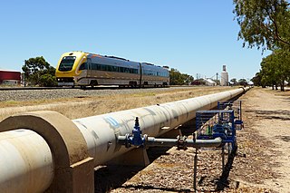
Merredin is a town in Western Australia, located in the central Wheatbelt roughly midway between Perth and Kalgoorlie, on Route 94, Great Eastern Highway. It is located on the route of the Goldfields Water Supply Scheme, and as a result is also on the Golden Pipeline Heritage Trail.

Cunderdin is a town located in the Wheatbelt region of Western Australia 156 km east of Perth, along the Great Eastern Highway. Due to it being on the route of the Goldfields Water Supply Scheme it is also on the Golden Pipeline Heritage Trail. It is a rural community consisting of a district high school and an agricultural college.

The Division of O'Connor is an Australian electoral division in the state of Western Australia. It is one of Western Australia's three rural seats, and one of the largest electoral constituencies in the world.

The Prospector is a rural passenger train service in Western Australia operated by Transwa between East Perth and Kalgoorlie. On this service, two trains depart almost at the same time in opposite directions, one travelling between East Perth and Kalgoorlie, and the other between Kalgoorlie and East Perth. The original vehicles ordered in 1968 for trains providing this service were replaced in 2004 with vehicles capable of reducing journey times to 6 hours 45 minutes.

Kellerberrin is a town in the Wheatbelt region of Western Australia, 205 kilometres (127 mi) east of Perth on the Great Eastern Highway. The town serves as a stop on the Prospector and MerredinLink rural train services. It is also located on the Golden Pipeline Heritage Trail.
The Eastern Goldfields Railway was built in the 1890s by the Western Australian Government Railways to connect Perth with the Eastern Goldfields at Coolgardie and Kalgoorlie.
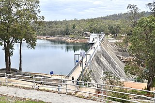
Mundaring Weir is a concrete gravity dam located 39 kilometres (24 mi) from Perth, Western Australia in the Darling Scarp. The dam and reservoir form the boundary between the suburbs of Reservoir and Sawyers Valley. The dam impounds the Helena River.

The Goldfields Water Supply Scheme is a pipeline and dam project that delivers potable water from Mundaring Weir in Perth to communities in Western Australia's Eastern Goldfields, particularly Coolgardie and Kalgoorlie. The project was commissioned in 1896 and completed in 1903.
C. Y. O'Connor College of TAFE, established in July 1994, is a Technical and Further Education institute servicing the Wheatbelt region of Western Australia.
The Kep Track is a bicycle, walking and horse track in the Darling Range and further east in Western Australia.
Burlong Pool is a section of the Avon River in Western Australia between Spencers Brook and Northam.
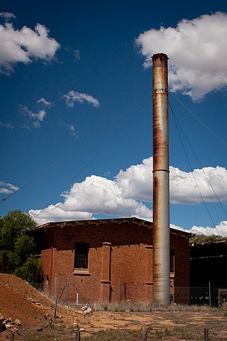
Railway dams and reservoirs were used to supply water to an extensive railway system that ventured into low rainfall, and poor water quality areas of the inner regions of Western Australia in the 1890s.

Western Australian Government Railways railway system during its peak operational time in the 1930s to 1950s was a large system of over 6,400 kilometres (4,000 mi) of railway line.
Yerbillon, Western Australia was the location of Number 5 Pumping station on the Goldfields Water Supply Scheme, and is the location of the current pumping station number 11 on the pipeline. It was also located on the Eastern Goldfields Railway.
Ghouli, Western Australia was the location of Number 6 Pumping station on the Goldfields Water Supply Scheme, and is the location of the current pumping station number 14 on the pipeline.
