
Northam is a town in the Australian state of Western Australia, situated at the confluence of the Avon and Mortlock Rivers, about 97 kilometres (60 mi) east-northeast of Perth in the Avon Valley. At the 2016 census, Northam had a population of 6,548. Northam is the largest town in the Avon region. It is also the largest inland town in the state not founded on mining.

Mundaring is a suburb located 34 km east of Perth on the Great Eastern Highway. The suburb is located within the Shire of Mundaring.

Southern Cross is a town in Western Australia, 371 kilometres east of state capital Perth on the Great Eastern Highway. It was founded by gold prospectors in 1888, and gazetted in 1890. It is the major town and administrative centre of the Shire of Yilgarn. At the 2016 census, Southern Cross had a population of 680.

Great Eastern Highway is a 590-kilometre-long (370 mi) road that links the Western Australian capital of Perth with the city of Kalgoorlie. A key route for road vehicles accessing the eastern Wheatbelt and the Goldfields, it is the western portion of the main road link between Perth and the eastern states of Australia. The highway forms the majority of National Highway 94, although the alignment through the Perth suburbs of Guildford and Midland, and the eastern section between Coolgardie and Kalgoorlie are not included. Various segments form parts of other road routes, including National Route 1, Alternative National Route 94, and State Route 51.

The Eastern Railway is the main railway route between Fremantle and Northam in Western Australia. It opened in stages between 1881 and 1893. The line continues east to Kalgoorlie as the Eastern Goldfields Railway.

The Railway Reserves Heritage Trail – also on some maps as Rail Reserve Heritage Trail or Rail Reserves Historical Trail, and frequently referred to locally as the Bridle Trail or Bridle Track – is within the Shire of Mundaring in Western Australia.
The Mundaring Branch Railway is an historical section of the original Eastern Railway main line across the Darling Scarp in the Western Australian Government Railways (WAGR) system.
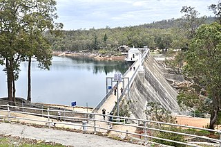
Mundaring Weir is a dam located 39 kilometres (24 mi) from Perth, Western Australia in the Darling Scarp. The dam and reservoir form the boundary between the suburbs of Reservoir and Sawyers Valley. The dam impounds the Helena River.

Sawyers Valley is sited on the Great Eastern Highway about 40 kilometres from Perth, Western Australia in the Shire of Mundaring. The community began as a sawmill and railway siding to process timber from the forest surrounding the Helena River to the south. Local employment included forest and Goldfields Water Supply Scheme maintenance, small orchards, and the Midland Railway Workshops.

Railways in Western Australia were developed in the 19th century both by the Government of Western Australia and a number of private companies. Today passenger rail services are controlled by the Public Transport Authority through Transperth, which operates public transport in Perth, and Transwa, which operates country passenger services. Great Southern Rail operates the Indian Pacific.

The Goldfields Water Supply Scheme is a pipeline and dam project that delivers potable water from Mundaring Weir in Perth to communities in Western Australia's Eastern Goldfields, particularly Coolgardie and Kalgoorlie. The project was commissioned in 1896 and completed in 1903.

The Shire of Mundaring is a local government area in eastern metropolitan Perth, the capital of Western Australia. The Shire covers an area of 645 square kilometres (249 sq mi) and had a population of approximately 38,000 as at the 2016 Census.

Bellevue railway station was a junction station on the Eastern Railway in the Perth suburb of Bellevue.

Clackline is a locality in the Wheatbelt region of Western Australia, about 80 kilometres (50 mi) east-north-east of Perth.

Golden Pipeline Heritage Trail was a project conducted by the National Trust of Western Australia along the Goldfields Water Supply Scheme pipeline at the time the pipeline was being celebrated for its 100 years of operation.
The Clackline to Miling railway branch, originally known as the Clackline to Newcastle railway line, is a railway line in Western Australia.

Western Australian Government Railways railway system during its peak operational time in the 1930s to 1950s was a large system of over 6,400 kilometres (4,000 mi) of railway line.
Clackline Bridge is a road bridge in Clackline, Western Australia, 77 kilometres (48 mi) east of Perth in the Shire of Northam, that carried the Great Eastern Highway until 2008. It is the only bridge in Western Australia to have spanned both a waterway and railway, the Clackline Brook and the former Eastern Railway alignment. The mainly timber bridge has a unique curved and sloped design, due to the difficult topography and the route of the former railway. The bridge was designed in 1934 to replace two dangerous rail crossings and a rudimentary water crossing. Construction began in January 1935, and was completed relatively quickly, with the opening ceremony held in August 1935. The bridge has undergone various improvement and maintenance works since then, including widening by three metres (10 ft) in 1959–60, but remained a safety hazard, with increasing severity and numbers of accidents through the 1970s and 1980s. Planning for a highway bypass of Clackline and the Clackline Bridge began in the 1990s, and it was constructed between January 2007 and February 2008. The local community had been concerned that the historic bridge would be lost, but it remains in use as part of the local road network, and has been listed on both the Northam Municipal Heritage Inventory and the Heritage Council of Western Australia's Register of Heritage Places.
Tourist Drives in Western Australia are routes through areas of scenic or historic significance, designated by route markers with white numbers on a brown shield. Tourist Drives were introduced into Western Australia while Eric Charlton was the state government Minister for Transport in the 1990s. The 28 numbered routes collectively traverse more than 2,000 kilometres (1,200 mi) across the state. In addition to the Tourist Drives, there are unnumbered routes such as the Golden Pipeline Heritage Trail, and local governments may designate and maintain local scenic drives, generally unnamed and unnumbered.

Toodyay railway station is located on the Eastern Railway in the Avon River town of Toodyay in Western Australia.
