Balga is a suburb of Perth, the capital city of Western Australia, 13 kilometres (8 mi) north of Perth city's central business district (CBD). Its local government area is the City of Stirling. Mark Irwin is the current mayor.

Marangaroo is a suburb of Perth, Western Australia. It is located approximately 18 km north of Perth City, within the City of Wanneroo. It is home to the Marangaroo Golf Course.
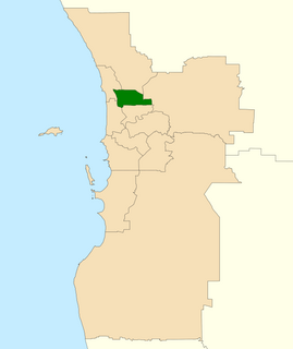
The Division of Cowan is an Australian Electoral Division in Western Australia.
Mitchell Freeway is a 36-kilometre-long (22 mi) freeway in the northern suburbs of Perth, Western Australia, linking central Perth with the city of Joondalup. It is the northern section of State Route 2, which continues south as Kwinana Freeway and Forrest Highway. Along its length are interchanges with several major roads, including Graham Farmer Freeway and Reid Highway. The southern terminus of the Mitchell Freeway is at the Narrows Bridge, which crosses the Swan River, and the northern terminus is at Hester Avenue, Clarkson, a suburb within the City of Wanneroo.
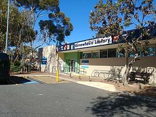
Girrawheen is a northern suburb of Perth, the capital city of Western Australia. Its local government area is the City of Wanneroo.
Madeley is a suburb of Perth, the capital city of Western Australia 20 kilometres (12 mi) north of Perth's central business district. Its local government area is the City of Wanneroo. Previously part of Landsdale, much of the suburb was rural in character until the 1990s, with market gardening a common activity. From 2001 onwards, extensive property development resulted in massive population growth, with the Property Investor Magazine of December 2007 estimating a growth rate of 33.3% per year.

Roe Highway is a 35-kilometre-long (22 mi) limited-access highway and partial freeway in Perth, Western Australia, linking Kewdale with the city's north-eastern and south-western suburbs. The northern terminus is at Reid Highway and Great Northern Highway in Middle Swan, and the southern terminus is with Murdoch Drive at the Kwinana Freeway interchange in Bibra Lake. Roe Highway, in addition to Reid Highway, form State Route 3, a partial ring road around the outer suburbs of the Perth metropolitan area. Roe Highway also forms part of National Highway 94 from Great Eastern Highway Bypass to Great Eastern Highway, and National Highway 95 from Great Eastern Highway to Great Northern Highway.

Wanneroo Road is a 44-kilometre (27 mi) arterial highway in the northern suburbs of Perth, Western Australia linking Joondanna and Yokine in the south with Wanneroo and Yanchep in the north. As part of State Route 60, it begins from Charles Street in the inner city and becomes Indian Ocean Drive up to Dongara.

Reid Highway is a 23-kilometre (14 mi) east-west highway and partial freeway in the northern suburbs of Perth, Western Australia, linking North Beach with Middle Swan. As part of State Route 3, it forms half of Perth's outer ring road along with Roe Highway, which it joins onto at its eastern terminus.

Tonkin Highway is an 81-kilometre-long (50 mi) north–south highway and partial freeway in Perth, Western Australia, linking Perth Airport and Kewdale with the city's north-eastern and south-eastern suburbs. As of April 2020, the northern terminus is at the interchange with Brand Highway and Great Northern Highway in Muchea, and the southern terminus is at Thomas Road in Oakford. It forms the entire length of State Route 4, and connects to several major roads. Besides Brand Highway and Great Northern Highway, it also connects to Reid Highway, Great Eastern Highway, Leach Highway, Roe Highway, and Albany Highway.

Marmion Avenue is a 40-kilometre (25 mi) arterial road in the northern coastal suburbs of Perth, Western Australia, linking Trigg in the south with Yanchep in the north. It forms part of State Route 71 along with West Coast Highway, which it joins onto at its southern terminus.
Joondalup Drive is a major distributor road in the northern suburbs of Perth, Western Australia. The road travels through the City of Joondalup's central business district and extends for a few kilometres east through neighbouring residential suburbs in the City of Wanneroo. The road was extended in 2005 to the northern suburb of Banksia Grove to provide easy access for residents to Joondalup's city centre, and to provide a complete connecting route to the Brand Highway from the Mitchell Freeway.

Alexander Drive is a major north–south arterial road in the northern suburbs of Perth, Western Australia, connecting Perth's central business district (CBD) with Edith Cowan University's Mount Lawley campus and the Malaga industrial area, as well as newer development suburbs to Perth's north. It is used by Transperth bus routes, including the 360, 361 and 362. Alexander Drive was named after Mr S.B. Alexander, a former Wanneroo Road Board member. Alexander Drive runs through the following local government areas City of Wanneroo, City of Swan, City of Bayswater and City of Stirling.

Beechboro Road is a north–south arterial road located in the northeastern suburbs of Perth, Western Australia, connecting Morley and Bayswater with areas further north. Until the construction of the nearby section of Tonkin Highway between 1984 and 1992, and later, during the NorthLink WA road project between 2016 and 2019, Beechboro Road was one of northeastern Perth's most important routes. The road is discontinuous at Tonkin Highway, with the section from Tonkin Highway to Walter Road officially known as Beechboro Road North, and the section running through Bayswater as Beechboro Road South.
Beach Road is a major east-west road in the northern suburbs of Perth, Western Australia, connecting Perth's inner northern beachside suburbs and inland state housing areas with shopping and public transport facilities at Warwick and the Malaga industrial area. It was mostly built between 1967 and 1974, and is a dual carriageway for most of its length, except for a small western part between Marmion Avenue and the coast, which is a minor residential distributor road and is discontinuous at Marmion Avenue. Beach Road also serves as a local government boundary. From Alexander Drive to Wanneroo Road, Beach Road is the boundary with the City of Wanneroo on the northern side and the City of Stirling on the southern side. From Wanneroo Road to the coast Beach Road is the boundary with the City of Joondalup on the northern side and the City of Stirling on the southern side.

Whitfords Avenue is an arterial east–west road located in the northern suburbs of Perth, Western Australia.
Ocean Reef Road is an arterial east-west road in Perth, Western Australia. It is located within the northern suburbs of Perth, from Ocean Reef in the west, to Landsdale in the east, with a portion travelling northwards along the coast to Iluka.
Warwick Road is an arterial east-west road located in the northern suburbs of Perth, Western Australia. It was built in 1969 to service the Shire of Wanneroo parts of the Hamersley Development Scheme, which was later split into the suburbs of Duncraig, Warwick and Greenwood. Its original alignment, which was gazetted in 1949 as Road No. 10578 by the Wanneroo Road Board, was a straight east-west road extending to Alexander Drive, but in the mid-1970s, the alignment was altered southwards in the vicinity of the freeway alignment, and in the late 1970s, the section east of Wanneroo Road was split off to form Marangaroo Drive.

Gnangara Road is an arterial east-west road in Perth, Western Australia. It is located within the northern suburbs of Perth, from Madeley in the west, to Henley Brook in the east. Gnangara Road provides a connection between Great Northern Highway and Wanneroo Road. The construction of the Ocean Reef Road extension in 2011 altered the road network in the Landsdale area in Landsdale. The plans show Gnangara Road as discontinuous between Mirrabooka Avenue and Alexander Drive, with the Mirrabooka Avenue and Ocean Reef Road extensions linking the two sections. Following construction, those linking road sections were named as Gnangara Road, allowing the road to remain continuous.

Marangaroo Drive is an arterial east-west road located in the northern suburbs of Perth, Western Australia. This road was originally part of Warwick Road, but in the late 1970s, Warwick Road was realigned, so the section of Warwick Road that was east of Wanneroo Road was discontinuous with the part that was west. The part that was east was renamed Marangaroo Drive, after the suburb Marangaroo. Marangaroo Drive is now extended through the suburb of Ballajura so it connects with Hepburn Avenue.

