
Hamersley is a residential suburb 14 kilometres north-northwest of the central business district of Perth, the capital of Western Australia, and six kilometres (4 mi) from the Indian Ocean. The suburb adjoins two major arterial roads—Mitchell Freeway to the west and Reid Highway to the south—and is within the City of Stirling local government area. It was built during the late 1960s and 1970s as part of the Government of Western Australia's response to rapidly increasing land prices across the metropolitan area.

Greenwood is a suburb of Perth, Western Australia, located in the City of Joondalup. The suburb is located 18 km from Perth's central business district. It is bordered by the Mitchell Freeway, Hepburn ave, Wanneroo road and Warwick road.
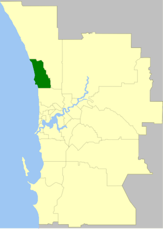
The Mitchell Freeway is a 36-kilometre-long (22 mi) freeway in the northern suburbs of Perth, Western Australia, linking central Perth with the city of Joondalup. It is the northern section of State Route 2, which continues south as Kwinana Freeway and Forrest Highway. Along its length are interchanges with several major roads, including the Graham Farmer Freeway and Reid Highway. The southern terminus of the Mitchell Freeway is at the Narrows Bridge, which crosses the Swan River, and the northern terminus is at Hester Avenue, Clarkson, a suburb within the City of Wanneroo.

Duncraig is a northern suburb of Perth, the capital city of Western Australia, and is located 16 kilometres (10 mi) north of Perth's central business district (CBD) between Marmion Avenue and Mitchell Freeway. Its local government area is the City of Joondalup.

Merriwa is a coastal, northern suburb of Perth, Western Australia, 36 kilometres (22 mi) north of the central business district. It is part of the City of Wanneroo local government area. It is a predominantly residential suburb, containing two RAAF retirement villages.

Wanneroo Road is a 44-kilometre (27 mi) arterial highway in the northern suburbs of Perth, Western Australia linking Joondanna and Yokine in the south with Wanneroo and Yanchep in the north. As part of State Route 60, it begins from Charles Street in the inner city and becomes Indian Ocean Drive up to Dongara.
The City of Joondalup is a local government area in Perth, Western Australia. Its central business district is located in the suburb Joondalup, and it includes the town centres of Hillarys and Warwick.

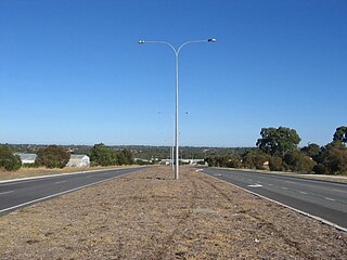
Reid Highway is a 23-kilometre (14 mi) east-west highway and partial freeway in the northern suburbs of Perth, Western Australia, linking North Beach with Middle Swan. As part of State Route 3, it forms half of Perth's outer ring road along with Roe Highway, which it joins onto at its eastern terminus.

Marmion Avenue is a 40-kilometre (25 mi) arterial road in the northern coastal suburbs of Perth, Western Australia, linking Trigg in the south with Yanchep in the north. It forms part of State Route 71 along with West Coast Highway, which it joins onto at its southern terminus.
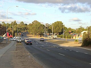
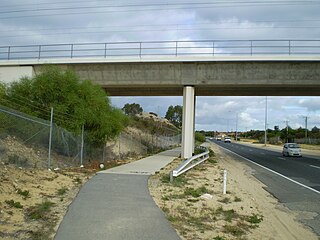
Erindale Road is a connector road in the northern suburbs of Perth, Western Australia, providing residents of the suburbs of Hamersley and Warwick with a connection to Reid Highway and Mitchell Freeway. The road is a dual carriageway with two lanes in each direction for most of its length, and continues from Warwick Road as Cockman Road through Greenwood, and from the Gwelup end as North Beach Road.
Beach Road is a major east-west road in the northern suburbs of Perth, Western Australia, connecting Perth's inner northern beachside suburbs and inland state housing areas with shopping and public transport facilities at Warwick and the Malaga industrial area. It was mostly built between 1967 and 1974, and is a dual carriageway for most of its length, except for a small western part between Marmion Avenue and the coast, which is a minor residential distributor road and is discontinuous at Marmion Avenue. Beach Road also serves as a local government boundary. From Alexander Drive to Wanneroo Road, Beach Road is the boundary with the City of Wanneroo on the northern side and the City of Stirling on the southern side. From Wanneroo Road to the coast Beach Road is the boundary with the City of Joondalup on the northern side and the City of Stirling on the southern side.
Yanchep Beach Road is an east-west road in outer northern Perth; it provides access to the outermost northern coastal suburbs of Yanchep and Two Rocks from Wanneroo Road as it leaves the Perth metropolitan area. The road is mostly a single carriageway with one lane in each direction, and commences in the Yanchep National Park near Lake Yonderup. It was built in the early 1970s to service land owned by the Bond Corporation and became a vital route during the operation of Atlantis Marine Park between 1981 and 1990. It has decreased in importance following the opening of the Marmion Avenue extension to Yanchep in 2008.

Hepburn Avenue is an arterial east-west road in the northern suburbs of Perth, Western Australia. The road links Sorrento in the west with Malaga and Whiteman in the east. It also connects the residential developments that span its length with several local facilities, as well as major road routes into central Perth.

Whitfords Avenue is an arterial east–west road located in the northern suburbs of Perth, Western Australia.
Burns Beach Road is an arterial east-west road in Perth, Western Australia, linking the suburbs of Burns Beach and Iluka to the Mitchell Freeway and Joondalup. It forms the entirety of State Route 87 and was the northern terminus of Mitchell Freeway and State Route 2 from 2008 to 2017, when the freeway was extended to Hester Avenue.
Ocean Reef Road is an arterial east-west road in Perth, Western Australia. It is located within the northern suburbs of Perth, from Ocean Reef in the west, to Landsdale in the east, with a portion travelling northwards along the coast to Iluka.

North Beach Road is a distributor road in the northern suburbs of Perth, Western Australia, running from Gwelup to North Beach. It is mostly a two-lane divided carriageway. The central section of the road, from Reid Highway to Erindale Road, is part of State Route 77. The route continues along Erindale Road, while North Beach Road heads south to Karrinyup Road.
Hodges Drive is a main west–east road in Joondalup, north of Perth, Western Australia. It begins in the suburb of Ocean Reef at a T-junction with Ocean Reef Road and runs through the residential areas in Ocean Reef, Connolly and Heathridge, before terminating at Joondalup Drive. The road continues from there as Grand Boulevard. Hodges Drive is a four lane dual-carriageway for its entire length.

Hester Avenue is an east-west distributor road in the northern suburbs of Perth, Western Australia, located within the City of Wanneroo. It primarily links the coastal suburbs of the Clarkson-Butler region to the arterial highway Wanneroo Road in the east, and is the current northern terminus of the Mitchell Freeway.

Marangaroo Drive is an arterial east-west road located in the northern suburbs of Perth, Western Australia. This road was originally part of Warwick Road, but in the late 1970s, Warwick Road was realigned, so the section of Warwick Road that was east of Wanneroo Road was discontinuous with the part that was west. The part that was east was renamed Marangaroo Drive, after the suburb Marangaroo. Marangaroo Drive is now extended through the suburb of Ballajura so it connects with Hepburn Avenue.
