The Darling Scarp, also referred to as the Darling Range or Darling Ranges, is a low escarpment running north–south to the east of the Swan Coastal Plain and Perth, Western Australia. The escarpment extends generally north of Bindoon, to the south of Pemberton. The adjacent Darling Plateau goes easterly to include Mount Bakewell near York and Mount Saddleback near Boddington. It was named after the Governor of New South Wales, Lieutenant-General Ralph Darling.

Forrestfield is a suburb of the City of Kalamunda in Western Australia. It lies 15 kilometres to the south-east of Perth at the base of the Darling Scarp and the southern border of Perth Airport.
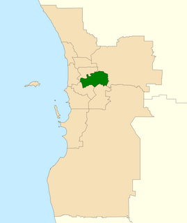
The Division of Swan is an Australian electoral division located in Western Australia.

Albany Highway links Western Australia's capital city Perth with its oldest settlement, Albany, on the state's south coast. The 405-kilometre-long (252 mi) highway travels through the southern Wheatbelt and Great Southern regions, and is designated State Route 30 for most of its length. Outside of Perth the highway is predominately a sealed, single carriageway with regular overtaking lanes in some undulating areas. Albany Highway commences at The Causeway, a river crossing that connects to Perth's central business district. The highway heads south-east through Perth's metropolitan region, bypassed in part by Shepperton Road and Kenwick Link, and continues south-eastwards through to Albany. It intersects several major roads in Perth, including the Leach, Tonkin, Brookton, and South Western highways. The rural section of Albany Highway connects to important regional roads at the few towns and roadhouses along the route, including Coalfields Highway at Arthur River, Great Southern Highway at Cranbrook, and Muirs Highway at Mount Barker.

Great Eastern Highway is a 590-kilometre-long (370 mi) road that links the Western Australian capital of Perth with the city of Kalgoorlie. A key route for road vehicles accessing the eastern Wheatbelt and the Goldfields, it is the western portion of the main road link between Perth and the eastern states of Australia. The highway forms the majority of National Highway 94, although the alignment through the Perth suburbs of Guildford and Midland, and the eastern section between Coolgardie and Kalgoorlie are not included. Various segments form parts of other road routes, including National Route 1, Alternative National Route 94, and State Route 51.

The Division of Hasluck is an electoral division of the Australian House of Representatives, located in Western Australia.

The Helena River is a tributary of the Swan River in Western Australia. The river rises in country east of Mount Dale and flows north-west to Mundaring Weir, where it is dammed. It then flows west until it reaches the Darling Scarp.

Roe Highway is a 35-kilometre-long (22 mi) limited-access highway and partial freeway in Perth, Western Australia, linking Kewdale with the city's north-eastern and south-western suburbs. The northern terminus is at Reid Highway and Great Northern Highway in Middle Swan, and the southern terminus is with Murdoch Drive at the Kwinana Freeway interchange in Bibra Lake. Roe Highway, in addition to Reid Highway, form State Route 3, a partial ring road around the outer suburbs of the Perth metropolitan area. Roe Highway also forms part of National Highway 94 from Great Eastern Highway Bypass to Great Eastern Highway, and National Highway 95 from Great Eastern Highway to Great Northern Highway.

Tonkin Highway is an 81-kilometre-long (50 mi) north–south highway and partial freeway in Perth, Western Australia, linking Perth Airport and Kewdale with the city's north-eastern and south-eastern suburbs. As of April 2020, the northern terminus is at the interchange with Brand Highway and Great Northern Highway in Muchea, and the southern terminus is at Thomas Road in Oakford. It forms the entire length of State Route 4, and connects to several major roads. Besides Brand Highway and Great Northern Highway, it also connects to Reid Highway, Great Eastern Highway, Leach Highway, Roe Highway, and Albany Highway.
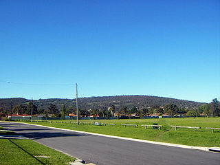
High Wycombe is a suburb of Perth, Western Australia, within the City of Kalamunda. High Wycombe lies east of the Perth CBD at the base of the Darling Scarp. Formerly part of Maida Vale, the suburb was officially declared on 2 June 1978; its name, which was first used in 1958 by a subdivider, Western Agencies, and refers to the town in Buckinghamshire where one of the partners in the firm was born.
Maida Vale is a suburb of Perth, Western Australia, located within the City of Kalamunda. Kalamunda Road runs through the suburb. Its first European settler was William Henry Mead who arrived in 1873, building a home in the Ridge Hill area and establishing an orchard named Orangedale. It was named in 1910 after a property name of another settler, WH McCormack. The name is believed to be derived from the eponymous area of west London.

Great Eastern Highway Bypass is a limited-access dual carriageway linking Great Eastern Highway and Roe Highway in Perth, Western Australia. Together with a section of Roe Highway, it bypasses the historical Guildford and Midland localities, through which the original, urban and slower Great Eastern Highway passes.

The City of Kalamunda is a local government area in the eastern metropolitan region of the Western Australian capital city of Perth about 25 kilometres (16 mi) east of Perth's central business district. The area covers 324 square kilometres (125 sq mi), much of which is state forest rising into the Darling Scarp to the east. In the mid 2010s, the area had a population of 57 thousand people.
Toodyay Road is a mostly 2-lane undivided single carriageway in Western Australia, running from the north-eastern Perth suburb of Middle Swan, through Gidgegannup and Bailup, to the Wheatbelt town of Toodyay. It is signposted as State Route 50.

Welshpool Road is a major arterial road running through the metropolitan area of Perth, Western Australia. Although the road is now split in two, having had its western and eastern sections disconnected due to the extension of Roe Highway, it remains Welshpool's second most important road, and the highest quality access road for the Darling Scarp.

Guildford Cemetery is a cemetery in the southern part of South Guildford, Western Australia, located between the Great Eastern Highway Bypass and Kalamunda Road adjacent to the Perth Airport.
Abernethy Road is a 14.7-kilometre (9.1 mi) long minor arterial road linking Belmont with the Great Eastern Highway Bypass in Hazelmere, a suburb of Perth, Western Australia.
Kenwick Link is a major road in Perth, Western Australia that bypasses Albany Highway in Beckenham and Kenwick. It is part of State Route 30, while the bypassed section of Albany Highway is allocated Alternate State Route 30. The road also provides access to Roe Highway, which does not connect to Albany Highway. It is a controlled-access road for its entire length, with a grade-separated interchange at Roe Highway, and at-grade intersections elsewhere, including traffic lights at Royal Street and both Albany Highway junctions. Main Roads Western Australia maintains and controls all of Kenwick Link, and uses the internal designation Highway H22 Wimbledon–Rupert Street Link.
Orrong Road is a major arterial road servicing the metropolitan area of Perth, Western Australia as well as the south-eastern continuation of the Graham Farmer Freeway. It is a dual carriageway for its entire length, with multiple sets of traffic lights.

