
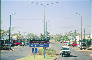
Camooweal is an outback town and locality in the City of Mount Isa, Queensland, Australia. The locality is on the Queensland border with the Northern Territory. In the 2016 census the locality of Camooweal had a population of 208 people.
Tennant Creek is a town located in the Northern Territory of Australia. It is the seventh largest town in the Northern Territory, and is located on the Stuart Highway, just south of the intersection with the western terminus of the Barkly Highway. At the 2016 census, Tennant Creek had a population of approximately 3,000, of which more than 50% (1,536) identified themselves as indigenous.

Pine Creek is a small town in the Katherine region of the Northern Territory, Australia. As at the 2016 Census there were 328 residents of Pine Creek, which is the fourth largest town between Darwin and Alice Springs.

The Barkly Tableland is a rolling plain of grassland in Australia. It runs from the eastern part of the Northern Territory into western Queensland. It is one of the five regions in the Northern Territory and covers 283,648 square kilometres (109,517 sq mi), 21% of the Northern Territory. The Barkly Tableland runs parallel to the southern shore of the Gulf of Carpentaria, from about Mount Isa, Queensland to near Daly Waters.

Newcastle Waters is a town and locality off the Stuart Highway in the Northern Territory. The nearest petrol station and accommodation is found 23 kilometres (14 mi) south at Elliott. The Newcastle Waters School draws most of its few students from the Marlinja homeland community which lies on the northern boundary of the town.

Renner Springs is a location in the Northern Territory of Australia. It is in the heart of the Barkly Tablelands cattle country. In fact, the town promotes itself as "The Heart of the Beef Country."
Alpurrurulam, from the original Aboriginal name Ilperrelhelame, also known as Lake Nash, is a locality in the Northern Territory of Australia located in the territory's east about 1,206 kilometres (749 mi) south-east of the territory capital of Darwin and about 570.1 kilometres (354.2 mi) east of the municipal seat of Tennant Creek and about 17 kilometres (11 mi) from the border with the state of Queensland. The town is at the end of the Sandover Highway, which floods each year during the wet season and cuts all road access to the community.

The Tablelands Highway is a 375 kilometre single lane sealed road in the Northern Territory, Australia. It runs from Barkly Homestead on the Barkly Highway to Cape Crawford near Borroloola on the Carpentaria Highway.
Elliott is a town in Northern Territory of Australia. It is almost halfway between Darwin and Alice Springs on the Stuart Highway. The town is in the Yapurkulangu ward of the Barkly Region. The area is the home of the Jingili people and the traditional name of the town is Kulumindini. At the 2016 census, Elliott had a population of 339.
Walhallow Station also once known as Walhallow Downs often just referred to as Walhallow is a pastoral lease that operates as a cattle station in the Northern Territory of Australia.

The Robinson River is a river in Australia's Northern Territory.

The Nicholson River is a river located in the Northern Territory and the state of Queensland, Australia.

Tree of Knowledge is a heritage-listed tree on the Barkly Highway, Camooweal, City of Mount Isa, Queensland, Australia. It was added to the Queensland Heritage Register on 8 September 2005.
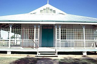
Community Hall is a heritage-listed former town hall at Barkly Highway, Camooweal, City of Mount Isa, Queensland, Australia. It was designed by Rooney Brothers and built from 1922 to 1923 by Hogarth & Hammond. It is also known as Barkly Tablelands Shire Hall. It was added to the Queensland Heritage Register on 21 October 1992.
Tablelands is a locality in the Northern Territory of Australia located about 858 kilometres (533 mi) south-east of the territory capital of Darwin.
Sandover is a locality in the Northern Territory of Australia located about 1,133 kilometres (704 mi) south of the territory capital of Darwin.

Anmatjere is a locality in the Northern Territory of Australia located about 1,088 kilometres (676 mi) south of the territory capital of Darwin.

Barkly is an outback locality in the City of Mount Isa, Queensland, Australia. The locality is on the Queensland border with Northern Territory. In the 2016 census Barkly had a population of 28 people.
Delamere is a locality in the Northern Territory of Australia about 369 kilometres (229 mi) south of the territory capital of Darwin.
Nicholson is a locality in the Northern Territory of Australia located in the territory's east adjoining the border with the state of Queensland about 963 kilometres (598 mi) south-east of the territory capital of Darwin.
