
The Balonne River, part of the Murray-Darling Basin system, is a short yet significant part of the inland river group of South West Queensland, Australia.

Gympie is a city and a locality in the Gympie Region, Queensland, Australia. Located in the Greater Sunshine Coast, Gympie is about 170.7 kilometres (110 mi) north of the state capital, Brisbane. The city lies on the Mary River, which floods Gympie occasionally. The locality of Gympie is the central business district for the city of Gympie and also the administrative centre for the Gympie Region local government area. In the 2021 census, Gympie had an urban population of 22,424 people.

St George is a rural town and locality in the Shire of Balonne, Queensland, Australia. It is the administrative centre for the Shire of Balonne.

Dirranbandi is a rural town and locality in the Shire of Balonne, Queensland, Australia. The locality is on the border of Queensland with New South Wales. In the 2021 census, the locality of Dirranbandi had a population of 610 people.

South Brisbane is an inner southern suburb in the City of Brisbane, Queensland, Australia. In the 2021 census, South Brisbane had a population of 14,292 people.

Mungindi is a town and locality on the border of New South Wales (NSW) and Queensland, Australia. The town is within Moree Plains Shire in New South Wales. Within Queensland, the locality is split between the Shire of Balonne and the Goondiwindi Region with the town in the Shire of Balonne. It possesses a New South Wales postcode. Mungindi sits on the Carnarvon Highway and straddles the Barwon River which is the border between New South Wales and Queensland. In the 2021 census, the locality of Mungindi had a population of 487 people in New South Wales and 124 people in Queensland, a total of 611 people.

Surat is a rural town and locality in the Maranoa Region, Queensland, Australia. In the 2021 census, the locality of Surat had a population of 402 people.

The Clarence River is a river situated in the Northern Rivers district of New South Wales, Australia. It rises on the eastern slopes of the Great Dividing Range, in the Border Ranges west of Bonalbo, near Rivertree at the junction of Koreelah Creek and Maryland River, on the watershed that marks the border between New South Wales and Queensland. It flows generally south, south east and north east, and is joined by twenty-four tributaries including Tooloom Creek and the Mann, Nymboida, Cataract, Orara, Coldstream, Timbarra, and Esk rivers. It descends 256 metres (840 ft) over the course of its 394-kilometre (245 mi) length and empties into the Coral Sea in the South Pacific Ocean, between Iluka and Yamba.

The Shire of Balonne is a local government area in South West Queensland, Australia, over 500 kilometres (310 mi) from the state capital, Brisbane. It covers an area of 31,104 square kilometres (12,009.3 sq mi), and has existed as a local government entity since 1879. It is headquartered in its main town, St George.

Mitchell is a rural town and locality in the Maranoa Region, Queensland, Australia. The town services the local area, a cattle and sheep farming district. In the 2021 census, the locality of Mitchell had a population of 995 people.
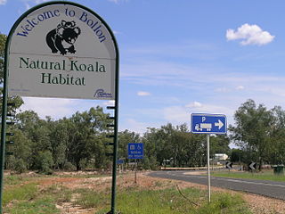
Bollon is a rural town and locality in the Shire of Balonne, Queensland, Australia. In the 2021 census, the locality of Bollon had a population of 174 people.

Thallon is a town and a locality in the Shire of Balonne, Queensland, Australia. In the 2021 census, the locality of Thallon had a population of 231 people.

The 1893 Brisbane flood, occasionally referred to as the Great Flood of 1893 or the Black February flood, occurred in 1893 in Brisbane, Queensland, Australia. The Brisbane River burst its banks on three occasions in February 1893. It was the occurrence of three major floods in the same month that saw the period named "Black February". There was also a fourth flood later in the same year in June. The river runs through the centre of Brisbane with much of the population living in areas beside the river. It first flooded on February 6 due to a deluge associated with a tropical cyclone, called "Buninyong".
The Maranoa River, part of the Murray-Darling basin, is a river situated in South West Queensland, Australia.
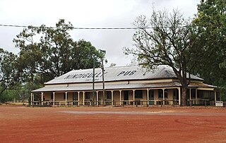
Nindigully is a rural town within the locality of Thallon in the Shire of Balonne, Queensland, Australia.

South West Queensland is a remote region in the Australian state of Queensland which covers 319,808 km2 (123,479 sq mi). The region lies to the south of Central West Queensland and west of the Darling Downs and includes the Maranoa district and parts of the Channel Country. The area is noted for its cattle grazing, cotton farming, opal mining and oil and gas deposits.

The Anchorage is a heritage-listed homestead at Wagoo Road, St George, Shire of Balonne, Queensland, Australia. It was built in 1903 by Arthur Bennett. It was added to the Queensland Heritage Register on 21 October 1992.

Weengallon is a rural locality in the Goondiwindi Region, Queensland, Australia. In the 2021 census, Weengallon had a population of 46 people.

Munna Creek is a locality split between the Fraser Coast Region and the Gympie Region, in Queensland, Australia. In the 2021 census, Munna Creek had a population of 22 people.
Alton is a town within the locality of St George in the Shire of Balonne, Queensland, Australia. As at 2018, it is completely covered in bushland and there are no buildings or evidence of the roads shown on the town map.
