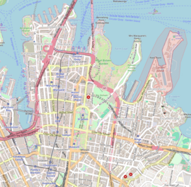
Darling Harbour is a harbour adjacent to the city centre of Sydney, New South Wales, Australia that is made up of a large recreational and pedestrian precinct that is situated on western outskirts of the Sydney central business district.
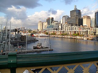
King Street Wharf, is a mixed-use tourism, commercial, residential, retail and maritime development on the eastern shore of Darling Harbour, an inlet of Sydney Harbour, Australia. Located on the western side of the city's central business district, the complex served as a maritime industrial area in the early and mid 20th century. It was redeveloped as part of extensive urban renewal projects around Sydney Harbour in the 1980s and 90s. The complex is host to a cluster of nine wharves, with the first two wharves currently in use by private ferry operator Captain Cook Cruises and a third recently decommissioned by Sydney Ferries.
The Eastern Suburbs is the metropolitan region directly to the east and south-east of the central business district in Sydney, New South Wales, Australia.

Chinatown is an urban enclave situated in the southern part of the Sydney Central Business District, in New South Wales, Australia. It comprises the majority of the Haymarket suburb, between Central station and Darling Harbour. It is part of the local government area of the City of Sydney, and is Australia's largest Chinatown.

Double Bay is a harbourside eastern suburb of Sydney, in the state of New South Wales, Australia 4 kilometres east of the Sydney central business district. It is the administrative centre of the local government area of the Municipality of Woollahra.

The Pyrmont Bridge, a heritage-listed swing bridge across Cockle Bay, is located in Darling Harbour, part of Port Jackson, west of the central business district in the City of Sydney local government area of New South Wales, Australia. Opened in 1902, the bridge initially carried motor vehicle traffic via the Pyrmont Bridge Road between the central business district and Pyrmont. Since 1981 the bridge has carried pedestrian and bicycle traffic only, as motor vehicles were diverted to adjacent freeway overpasses. The bridge was added to the New South Wales State Heritage Register on 28 June 2002, the centenary of its opening.

Darling Point is a harbourside eastern suburb of Sydney, Australia. It is 4 kilometres east of the Sydney central business district and is part of the local government area of Woollahra Council.

Balmain East is a suburb in the Inner West of Sydney, in the state of New South Wales, Australia. Balmain East is located three kilometres west of the Sydney central business district, in the local government area of the Inner West Council.

King Street is a street in the central business district of Sydney in New South Wales, Australia. It stretches from King Street Wharf and Lime Street near Darling Harbour in the west, to Queens Square at St. James railway station in the east.

Bathurst Street is a street in the Sydney central business district in New South Wales, Australia. Bathurst Street runs for 650 metres (2,130 ft) in a west–east direction with traffic flowing in this direction only. It is situated in the southern portion of the central business district. The western terminus of Bathurst Street is at Harbour Street, Darling Harbour, with the eastern terminus at Elizabeth Street, adjacent to Hyde Park.
Darling Harbour was an electoral district of the Legislative Assembly in the Australian state of New South Wales, in the vicinity of Darling Harbour. It was created in the 1904 re-distribution of electorates following the 1903 New South Wales referendum, which required the number of members of the Legislative Assembly to be reduced from 125 to 90. It consisted of the abolished seats of Sydney-Gipps and Sydney-Lang and parts of the abolished seats of Sydney-King and Sydney-Denison. In 1920, with the introduction of proportional representation, it was absorbed into Balmain.
Sydney-Lang was an electoral district of the Legislative Assembly in the Australian state of New South Wales, created in 1894 from part of the electoral district of West Sydney in inner Sydney and named after Presbyterian clergyman, writer, politician and activist John Dunmore Lang. It was west of George Street, generally south of Margaret Street, north of Hay Street and east of Darling Harbour. It was abolished in 1904 and absorbed into Darling Harbour.

St Andrew Parish, Cumberland is one of the 57 parishes of Cumberland County, New South Wales, a cadastral unit for use on land titles. It is one of the four small parishes in the Sydney city area, and is named after the church of St Andrew's. The parish was named while the church was still in the planning stages. The parish includes Pyrmont and the Darling Harbour area. It is bounded by Wattle Street in the south west, George Street in the south and east, and King Street in the north-east. It includes Town Hall railway station, which is on the eastern end of the parish.
St Philip Parish is one of the 57 parishes of Cumberland County, New South Wales, a cadastral unit for use on land titles. It is located on the western part of the original colony at Sydney Cove, which was to the west of the Tank Stream. It is one of the four small parishes in the Sydney city area and is named after the church of St Philip's. It includes the southern end of the Sydney Harbour Bridge, The Rocks, Dawes Point and Millers Point. It is bounded by Sydney Harbour in the north, King Street in the south, George Street in the south-east, and what was once the Tank Stream in the east. The northern end of Darling Harbour is the boundary in the west. It includes Wynyard railway station.
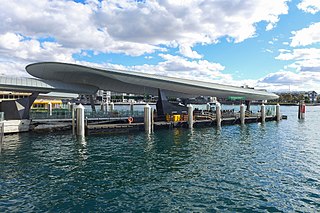
Barangaroo ferry wharf is a ferry wharf located on the eastern side of Darling Harbour, in Sydney, Australia. The wharf is the major public transport link of the Barangaroo precinct, situated west of the Sydney central business district. The complex consists two wharves, with provision for a third wharf in the future. It is serviced by Sydney Ferries' F3 Paramatta River and F4 Pyrmont Bay services. The wharf opened on 26 June 2017.

The Pyrmont Bay ferry service, officially known as F4 Pyrmont Bay, is a commuter ferry service in Sydney, New South Wales. Part of the Sydney Ferries network, it is operated by Transdev Sydney Ferries and services the Lavender Bay and Darling Harbour areas. It began operation on 25 October 2020, and replaced the western half of the F4 Cross Harbour ferry service. Emerald-class ferries and SuperCat ferries operate the service.
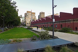
The Goods Line is an 800 m-long (2,625 ft) linear park and shared pedestrian pathway and cycleway in the suburb of Ultimo, in the City of Sydney, New South Wales, Australia. The corridor connects Railway Square to Darling Harbour in the south and passes both the University of Technology Sydney Broadway campus and the Australian Broadcasting Corporation Sydney head office. The Goods Line terminates in the north at the corner of Sussex and Hay Streets, in the Sydney central business district.

The Dundee Arms Hotel, commonly called The Dundee Arms, is a heritage-listed pub located at 171 Sussex Street, in the Sydney central business district, in the City of Sydney local government area of New South Wales, Australia. It was built in 1860. It was added to the New South Wales State Heritage Register on 2 April 1999.

The Railway Square road overbridge is a heritage-listed road overbridge carrying George Street over the former Darling Harbour goods railway line at Railway Square in the Sydney central business district, in the City of Sydney local government area of New South Wales, Australia. The property was added to the New South Wales State Heritage Register on 2 April 1999.
Darling Harbour, an electoral district of the Legislative Assembly in the Australian state of New South Wales was created in 1904 and abolished in 1913.