Surry Hills is an inner-east suburb of Sydney, in the state of New South Wales, Australia. Surry Hills is immediately south-east of the Sydney central business district in the local government area of the City of Sydney. Surry Hills is surrounded by the suburbs of Darlinghurst to the north, Chippendale and Haymarket to the west, Moore Park and Paddington to the east and Redfern to the south. It is often colloquially referred to as "Surry".
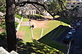
Randwick is a suburb in the Eastern Suburbs of Sydney, in the state of New South Wales, Australia. Randwick is located 6 kilometres south-east of the Sydney central business district and is the administrative centre for the local government area of the City of Randwick. The postcode is 2031.

Waverley is a suburb in the Eastern suburbs of Sydney, in the state of New South Wales, Australia. Waverley is located 7 kilometres east of the Sydney central business district, in the local government area of Waverley Council.

Ultimo is an inner-city suburb of Sydney, New South Wales, Australia.

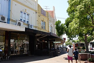
Woollahra is a suburb in the Eastern Suburbs of Sydney, in the state of New South Wales, Australia. Woollahra is located 5 kilometres east of the Sydney central business district, in the local government area of the Municipality of Woollahra. Woollahra is located on the traditional land of the Birrabirragal and Gadigal people of the Eora Nation. The Municipality of Woollahra takes its name from the suburb but its administrative centre is located in Double Bay. Woollahra is famous for its quiet, tree-lined residential streets and village-style shopping centre.

Paddington is an upscale Eastern Suburb of Sydney, in the state of New South Wales, Australia. Located 3 kilometres (1.9 mi) east of the Sydney central business district, Paddington lies across two local government areas. The portion south of Oxford Street lies within the City of Sydney, while the portion north of Oxford Street lies within the Municipality of Woollahra. It is often colloquially referred to as "Paddo".

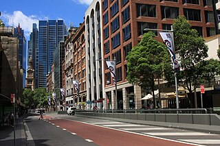
Bridge Street is a street in the central business district of Sydney in New South Wales, Australia. Bridge Street runs for 500 metres (1,600 ft) in a west–east direction with traffic flowing in both directions. It is situated in the northern portion of the central business district. The western terminus of Bridge Street is at George Street, with the eastern terminus at Macquarie Street, adjacent to the Chief Secretary's Building. From west to east, Bridge Street crosses Pitt and Phillip streets.

The St Michael's Anglican Church is a church in the Sydney suburb of Surry Hills. It is located on the corner of Albion and Flinders Street and together with the adjoining rectory and parish hall it is listed on the Register of the National Estate. In 2015 the church merged with Vine Church, which was an Anglican church plant that had started in Surry Hills in 2011. In 2017, the church changed its name to Vine Church to reflect the renewal the church has undergone and the life, love and freedom which are on offer to those who connect to Jesus.
York Street is a street in the Sydney central business district in New South Wales, Australia. York Street runs 1.050 kilometres (0.652 mi) in a north to south direction only and is used predominantly by buses from the northern districts of Sydney.

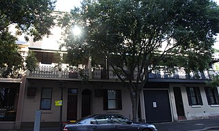
The 203–205 Albion Street, Surry Hills Cottages are two heritage-listed cottages located at 203–205 Albion Street in the inner city Sydney suburb of Surry Hills in the City of Sydney local government area of New South Wales, Australia. It was built in 1840 by George Hill. The property is owned by the Royal College of Pathologists of Australasia. It was added to the New South Wales State Heritage Register on 2 April 1999.

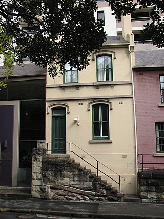
197, 199, 201 Albion Street terrace cottages are three heritage-listed terraced houses located at 197, 199, 201 Albion Street in the inner city Sydney suburb of Surry Hills in the City of Sydney local government area of New South Wales, Australia. It was added to the New South Wales State Heritage Register on 2 April 1999.
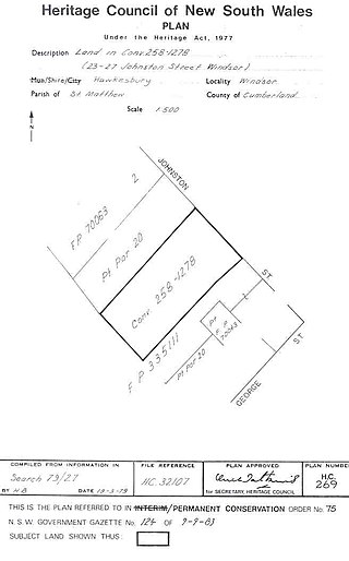
The Johnston Street terraces consists of heritage-listed attached terraced houses located at 23-27 Johnston Street, Windsor, City of Hawkesbury, New South Wales, Australia. It was added to the New South Wales State Heritage Register on 2 April 1999.

The Model Factory and Dwelling is a heritage-listed former factory, store and dwelling and now offices located at 120 Gloucester Street in the inner city Sydney suburb of The Rocks in the City of Sydney local government area of New South Wales, Australia. It was designed by George McRae and built from 1912 to 1913. It is also known as Chung Lun Building and (erroneously) the Housing Board Building. The property is owned by Property NSW, an agency of the Government of New South Wales. It was added to the New South Wales State Heritage Register on 10 May 2002.
67 Harrington Street, The Rocks is a heritage-listed serviced apartments complex and former terrace house located at 67 Harrington Street, in the inner city Sydney suburb of The Rocks in the City of Sydney local government area of New South Wales, Australia. It was built from 1885. It is also known as Stafford Apartments and 75 Harrington Street; Clocktower Development. The property is owned by Property NSW, an agency of the Government of New South Wales. It was added to the New South Wales State Heritage Register on 10 May 2002.

61–65 Harrington Street, The Rocks is a heritage-listed serviced apartments and former terrace house located at 61–65 Harrington Street, in the inner city Sydney suburb of The Rocks in the City of Sydney local government area of New South Wales, Australia. It was built from 1870. It is also known as Stafford Apartments and 75 Harrington Street; Clocktower Development. The property is owned by Property NSW, an agency of the Government of New South Wales. It was added to the New South Wales State Heritage Register on 10 May 2002.

90–92 Windmill Street, Millers Point is a heritage-listed historic site located at 90–92 Windmill Street, in the inner city Sydney suburb of Millers Point in the City of Sydney local government area of New South Wales, Australia. It was added to the New South Wales State Heritage Register on 2 April 1999.

86–88 Windmill Street, Millers Point is a heritage-listed residence located at 86–88 Windmill Street, in the inner city Sydney suburb of Millers Point in the City of Sydney local government area of New South Wales, Australia. It was added to the New South Wales State Heritage Register on 2 April 1999.

Stevens Terrace is a heritage-listed former boarding house and now residence located at 73 Windmill Street, in the inner city Sydney suburb of Millers Point in the City of Sydney local government area of New South Wales, Australia. The property was added to the New South Wales State Heritage Register on 2 April 1999.
90–92 Kent Street, Millers Point are heritage-listed terrace houses located at 90–92 Kent Street, Millers Point, City of Sydney, New South Wales, Australia. The property is owned by Department of Housing. It was added to the New South Wales State Heritage Register on 2 April 1999.
Joseph Alexander Kethel was an Australian architect notable for the many substantial private residences and pastoral homesteads he designed throughout New South Wales and the striking theatres, office buildings and Presbyterian Churches he designed in Sydney.