| Work | Suburb/city | Type | Style | Completed | Involvement | Image | Heritage registers | Notes |
|---|
| Admiralty House | Kirribilli | Government residence | Victorian Italianate | 1891-92 | Italianate enlargements |  | | [15] [16] [17] [18] |
| Annandale Post Office | Annandale | Post office | Federation Free Classical | 1896 | Architect | 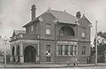 | - Commonwealth Heritage List
- Local register
- (Now defunct) RNE
| [19] [20] [21] |
| Armidale Post Office | Armidale | Post office | Federation Queen Anne | 1897 | Loggia only |  | | [22] [23] |
| Art Gallery of New South Wales | The Domain,Sydney | Art gallery | Federation Academic Classical | 1895-1906 | - Portico and oval lobby
- South and north galleries
- External reliefs
| 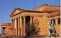 | - Local register
- (Now defunct) RNE
| [24] [25] |
| ASN Co building | 1-5 Hickson Road,The Rocks | Warehouse | Pre-Federation Anglo Dutch | 1884-1885 | |  | - NSW Register
- (Now defunct) RNE
| [26] [27] [28] |
| Australian Museum | College Street,Sydney | Natural history museum | | 1896-1899 | South wings | 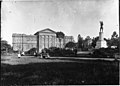 | - NSW Register
- (Now defunct) RNE
| [29] [30] |
| Banco Road Court | St James Road,Sydney | Court house | Federation Free Classical | 1895-1896 | Architect |  | - NSW Register
- (Now defunct) RNE
| [31] [32] [33] |
| Bloomfield Hospital | Orange | Hospital | | 1923-1931 | Initial design only | | NSW Register | [34] |
| Broken Hill Post Office | Broken Hill | Post office | Federation Arts and Crafts | 1890-1892 | Alterations and additions |  | - Commonwealth Heritage List
- NSW Register
- (Now defunct) RNE
| [35] [36] [37] |
Brooklyn Hotel
(Façade preserved as the Johnson's Building) | 229 George Street,The Rocks | Public hotel | Free Federation Style | 1912-1912 | Architect |  | - NSW Register
- (Now defunct) RNE
| [38] [39] |
| Burwood Post Office (former) | Burwood | Post office | Federation Anglo Dutch Revival | 1892 | Architect
(assisted by George Oakeshott) |  | - NSW Register
- (Now defunct) RNE
| [40] [41] |
| Casino Post Office | Casino | Post office | - Victorian Italianate
- Georgian Revival
| 1879 | Alterations and additions | | - Commonwealth Heritage List
- NSW Register
- (Now defunct) RNE
| [42] [43] [44] |
| Central Local Court House | 98 Liverpool Street,Sydney | Court house
(and former police station) | Federation Free Classical | 1892 | |  | - NSW Register
- (Now defunct) RNE
| [45] [46] |
| Central railway station | Railway Square | Terminus railway station | | 1901-1906 | - Main Terminus building
- Parcels Post Office
- Viaducts (with Deane)
|  | - (Now defunct) RNE
- Local register
| [47] [48] [49] |
| Colonial Secretary's building | 121 Macquarie Street,Sydney | Government administration | Victorian Second Empire | 1894-1896 | |  | - NSW Register
- (Now defunct) RNE
| [50] [51] |
| Coroner's Court (former) | 102-104 George Street,The Rocks | Coroner's Court and morgue | Federation Free Style | 1906-1908 | Architect | | - NSW Register
- (Now defunct) RNE
| [52] [53] |
Kitchen block,Cumberland Hospital and
Parramatta Female Factory (former) | Parramatta/Westmead | Hospital | - Federation
- Federation Arts and Crafts
| 1892-1893 | Alterations and additions | | | [54] [55] [56] [57] [58] |
| Customs House | Alfred Street,Sydney | Customs house | | 1896-1903 | Alterations and additions | 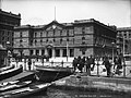 | - Commonwealth Heritage List
- NSW Register
- (Now defunct) RNE
| [59] [60] [61] |
| David Berry Hospital Precinct | Berry | Hospital | | 1909 | | | NSW Register | [62] |
| Glen Innes Post Office | Glen Innes | Post office | Federation Arts and Crafts | 1895-1896 | Architect |  | - Commonwealth Heritage List
- NSW Register
- (Now defunct) RNE
| [63] [64] [65] |
| Health Department Building (former) | 93-97 Macquarie Street,Sydney | Government administration
(now a hotel) | Federation Free Style | 1896-1898 | Architect |  | - NSW Register
- (Now defunct) RNE
| [66] [67] |
| Hestock | 14 Crescent Street,Hunters Hill | House | Federation Arts &Crafts | 1885 | Architect | | - NSW Register
- (Now defunct) RNE
| [68] [69] |
| Inverell Post Office | Inverell | Post office | Federation Arts and Crafts | 1904 | Architect | | - Commonwealth Heritage List
- NSW Register
| [70] [71] |
Leura
(now part of Cranbrook School,Sydney) | 24 Victoria Road,Bellevue Hill | House | Federation Queen Anne | 1891 | - Co-architect
- with Howard Joseland
| | NSW Register | [72] |
| Lidcombe Hospital Precinct | Lidcombe | Hospital | | 1885-1906 | - Dining Hall
- Superintendent's Residence
- Nine wards
| | - NSW Register
- (Now defunct) RNE
| [73] [74] [75] |
Liverpool TAFE College
(former Liverpool Hospital,Block F) | Liverpool | Teacher's college | | 1902-1907 | Alterations and additions |  | - NSW Register
- (Now defunct) RNE
| [76] [77] |
| Long Bay Correctional Centre | Malabar | Gaol | | 1899-1914 | Architect |  | NSW Register | [78] |
| Maitland Court House | Maitland | Court house | Federation Free Classical | 1895 | Architect | | - NSW Register
- (Now defunct) RNE
| [79] [80] |
| Millers Point Post Office | Millers Point | Post office | Federation Free Classical | 1891 | Architect | | - NSW Register
- (Now defunct) RNE
| [81] [82] |
| Mining Museum (former) | 36-64 George Street,The Rocks | Museum | Federation Warehouse | 1902-1909 | Architect |  | NSW Register | [83] |
| Mitchell Library,State Library of NSW | Sydney | Library | Federation Academic Classical | 1906-1910 | Architect |  | - NSW Register
- (Now defunct) RNE
| [84] [85] |
| Mudgee Post Office | Mudgee | Post office | Victorian Free Classical | 1902 | Alterations and additions | 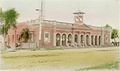 | - Commonwealth Heritage List
- NSW Register
- (Now defunct) RNE
| [86] [87] [88] [89] |
| Newcastle Court House | Newcastle | Court house | Victorian Italianate | 1902 | Alterations and additions |  | - NSW Register
- (Now defunct) RNE
| [90] [91] |
| Newcastle Customs House | Newcastle | Customs house | Italian Renaissance Revival | 1899 | Alterations and additions |  | - NSW Register
- (Now defunct) RNE
| [92] [93] |
| Newcastle Post Office | Newcastle | Post office | Federation Academic Classical | 1900-1903 | Architect |  | - Commonwealth Heritage List
- NSW Register
- (Now defunct) RNE
| [94] [95] [96] [97] |
| Paddington Post Office | Paddington | Post office | - Victorian Italianate
- Victorian Free Classical
| c. 1885 | Alterations and additions | 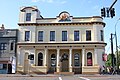 | - Commonwealth Heritage List
- NSW Register
- (Now defunct) RNE
| [98] [99] [100] |
| Parkes Post Office | Parkes | Post office | | 1901-1903 | Alterations and additions |  | - NSW Register
- (Now defunct) RNE
| [101] [102] |
| Pyrmont Post Office | Pyrmont | Post office | Federation Free Style | 1901 | Architect |  | - Commonwealth Heritage List
- NSW Register
- (Now defunct) RNE
| [103] [104] [105] |
Randwick Post Office (former)
and Jubilee Fountain | Randwick | Post office | Federation Free Style | 1897-1898 | Architect |  | - NSW Register
- (Now defunct) RNE
| [106] [107] |
Registrar-General's Building
(also called the Land Titles Office) | Prince Albert Road,Sydney | Government administration | Federation Gothic | 1908-1913 | Principal architect
(with E. H. Farmer) |  | - NSW Register
- (Now defunct) RNE
| [108] [109] |
Royal Botanic Gardens
Herbarium and Shelter House | The Domain | Herbarium and cottage | | 1899 | - Herbarium
- Lecture hall and library
- Museum and admin centre
| | - NSW Register
- (Now defunct) RNE
| [110] [111] [112] |
| Royal Edward Victualling Yard Group | Darling Island,Pyrmont | Naval warehouse and
ordinance stores (former) | Federation Warehouse | 1904-1912 | Architect
(Buildings A,B and C) |  | - NSW Register
- (Now defunct) RNE
| [113] [114] |
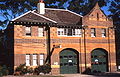
| Shop and Residence | 182 Cumberland Street,The Rocks | Shop and residence | Classic Free Style Edwardian | 1911-1912 | Architect
(assisted by E. L. Drew) | | NSW Register | [115] |
Silverwater Correctional Complex,
Erwin House and Engineer's Cottage | Silverwater | Gaol | | 1911-1918 | Alterations and additions | | NSW Register | [116] |
| Singleton Post Office (former) | Singleton | Former post office | | 1899 | Alterations and additions | | - NSW Register
- (Now defunct) RNE
| [117] [118] |
| State Abattoir,Admininstration Buildings | Homebush Bay / Sydnsy Olympic Park | Former offices | | 1915 | Architect (assisted by Principal Assistant Architect George McRae) | | | [119] |
Treasury Building (former)
now part of the InterContinental Hotel | 117-119 Macquarie Street,Sydney | Government administration | - Victorian Neo-Classical
- Italian Palazzo
| 1898-1900 | |  | - NSW Register
- (Now defunct) RNE
| [120] [121] |