Surry Hills, New South Wales

Last updated

Surry Hills
Sydney,  New South Wales
Surry Hills Library 2010.jpg
Surry Hills Library and Community Centre
Australia New South Wales location map blank.svg
Red pog.svg
Surry Hills
Surry Hills, New South Wales
Coordinates 33°53′10″S151°12′40″E / 33.88611°S 151.21111°E / -33.88611; 151.21111
Population15,828 (SAL 2021) [1]
Postcode(s) 2010
Elevation51 m (167 ft)
Area1.2 km2 (0.5 sq mi)
Location1 km (1 mi) SE of Sydney central business district
LGA(s) City of Sydney
State electorate(s)
Federal division(s) Sydney
Suburbs around Surry Hills:
Sydney central business district Darlinghurst Darlinghurst
Haymarket Surry Hills Paddington
Chippendale Redfern Moore Park

Surry Hills is an inner-east suburb of Sydney, in the state of New South Wales, Australia. Surry Hills is immediately south-east of the Sydney central business district in the local government area of the City of Sydney. Surry Hills is surrounded by the suburbs of Darlinghurst to the north, Chippendale and Haymarket to the west, Moore Park and Paddington to the east and Redfern to the south. [2] It is often colloquially referred to as "Surry".

Contents

It is bordered by Elizabeth Street and Chalmers Street to the west, Cleveland Street to the south, South Dowling Street to the east, and Oxford Street to the north. Crown Street is a main thoroughfare through the suburb with numerous restaurants, pubs and bars. Central is a locality in the north-west of the suburb around Central station. Prince Alfred Park is located nearby. Strawberry Hills is a locality around Cleveland and Elizabeth Streets and Brickfield Hill to the east of that.

A multicultural suburb, Surry Hills has had a long association with the Portuguese community of Sydney. [3]

History

The first land grants in Surry Hills were made in the 1790s. Major Joseph Foveaux received 105 acres (0.42 km2). His property was known as Surry Hills Farm, after the Surrey Hills in Surrey, England. Foveaux Street is named in his honour. [4] Commissary John Palmer received 90 acres (360,000 m2). He called the property George Farm and in 1800 Palmer also bought Foveaux's farm. In 1792, the boundaries of the Sydney Cove settlement were established between the head of Cockle Bay to the head of Woolloomooloo Bay. West of the boundary, which included present-day Surry Hills, was considered suitable for farming and was granted to military officers and free settlers.

After Palmer's political failures, his reduced financial circumstances forced the first subdivision and sale of his estate in 1814. Isaac Nichols bought Allotment 20, comprising over 6 acres (24,000 m2). Due to the hilly terrain, much of the suburb was considered remote and 'inhospitable'. In the early years of the nineteenth century the area around what is now Prince Alfred Park was undeveloped land known as the Government Paddocks or Cleveland Paddocks. A few villas were built in the suburb in the late 1820s. The suburb remained one of contrasts for much of the nineteenth century, with the homes of wealthy merchants mixed with that of the commercial and working classes.

A Surry Hills street scene, 1940s Salvation Army - Surry Hills Sunday morning service in street, Sept 1949, from Series 02- Sydney people & streets, 1948-1950, photographed by Brian Bird (6977871553).jpg
A Surry Hills street scene, 1940s

In 1820, Governor Macquarie ordered the consecration of the Devonshire Street Cemetery. A brick wall was erected before any interments took place to enclose its 4 acres (16,000 m2). Within a four-year period the cemetery was expanded by the addition of 7 acres (28,000 m2) to its south. A road was formed along the southern boundary of the cemetery in the first half of the 1830s and was called Devonshire Street. The Devonshire Street Cemetery, where many of the early settlers were buried, was later moved to build the Sydney railway terminus. Central railway station was opened on 4 August 1906. The area around Cleveland and Elizabeth streets was known as Strawberry Hills. Strawberry Hills post office was located at this intersection for many years. [5]

In 1833, the Nichols estate was subdivided and sold. One purchase was by Thomas Broughton and subsequently acquired by George Hill who constructed Durham Hall on this and adjoining lots. Terrace houses and workers' cottages were built in Surry Hills from the 1850s. Light industry became established in the area, particularly in the rag trade (clothing industry). It became a working class suburb, predominately inhabited by Irish immigrants. The suburb developed a reputation for crime and vice. The Sydney underworld figure Kate Leigh (1881–1964), lived in Surry Hills for more than 80 years.

In 1896 Patineur Grotesque one of Australia's first films and first comedy routine filmed was shot in Prince Alfred Park by Marius Sestier. [6]

Surry Hills was favoured by newly arrived families after World War II when property values were low and accommodation was inexpensive. From the 1980s, the area was gentrified, with many of the area's older houses and building restored and many new upper middle-class residents enjoying the benefits of inner-city living. The suburb is now a haven for the upper middle class and young rich. [7]

Trams

Tram lines from Eddy Avenue running into Elizabeth Street in the early 1940s Elizabeth St. from Eddy Ave. 1940s.jpg
Tram lines from Eddy Avenue running into Elizabeth Street in the early 1940s

The West Kensington via Surry Hills Line operated from 1881 down Crown Street as far as Cleveland Street as a steam tramway. It was extended to Phillip Street in 1909, Todman Avenue in 1912, and then to its final terminus down Todman Avenue in 1937. When the line was fully operational it branched from the tramlines in Oxford Street and proceeded down Crown Street to Cleveland Street in Surry Hills, then south along Baptist Street to Phillip Street, where it swung left into Crescent Street before running south along Dowling Street. It passed the Dowling Street Depot, then turned left into Todman Avenue, where it terminated at West Kensington. The line along Crown Street closed in 1957, the remainder stayed open until 1961 to allow access to Dowling Street Tram Depot. Transdev John Holland routes 301, 302 and 303 generally follow the route down Crown and Baptist Streets as far as Phillip Street. [8]

Urban character

Commercial buildings on the corner of Crown and Campbell Streets Crown Street-Campbell Street, Surry Hills, Sydney.jpg
Commercial buildings on the corner of Crown and Campbell Streets

Surry Hills has a mixture of residential, commercial and light industrial areas. It remains Sydney's main centre for fashion wholesale activities, particularly on the western side. The area is also home to a large LGBTQIA+ community, where Sydney's Gay and Lesbian Mardi Gras (Pride Parade) takes place each year.

Surry Hills Markets are held in Shannon Reserve at the corner of Crown and Collins Streets, on the first Saturday of every month, [9] and the Surry Hills Festival is an annual community event, attracting tens of thousands of visitors, held in and around Ward Park, Shannon Reserve, Crown Street and Hill Street. [10] The Surry Hills Library and Community Centre sits opposite Shannon Reserve and houses the local branch of the city library and the Surry Hills Neighbourhood Centre. [11]

Literature

The Harp in the South is a novel by Ruth Park. Published in 1948, it portrays the life of a Catholic Irish-Australian family in Surry Hills, which was an inner city slum at the time. A sequel, Poor Man's Orange , was published in 1949.

Transport

Central railway station, the largest station on the Sydney Trains and NSW TrainLink networks, sits on the western edge of Surry Hills. Surry Hills is also serviced by Transdev John Holland and Transit Systems buses. The Eastern Distributor is a major road, on the eastern edge of the suburb. Major thoroughfares are Crown Street, Cleveland Street, Bourke Street and Foveaux Street. Surry Hills is within easy walking distance of the Sydney CBD, and is included in a widening network of cycleways.

Major construction took place on the Surry Hills section of the CBD and South East Light Rail which opened in December 2019 and April 2020 respectively. [12] Transport for NSW managed this project. [13] It has been reported that there has been some disruption to local businesses because of the construction work taking place. [14]

Places of worship

St Peters Catholic Church St Peter's Catholic Church-Front.jpg
St Peters Catholic Church
Buddhist Temple Buddhist Temple Surry Hills 006.jpg
Buddhist Temple

Landmarks

Prince Alfred Park Prince Alfred Park 003.jpg
Prince Alfred Park
White Horse Hotel White Horse Hotel Surry Hills 001.jpg
White Horse Hotel
Surry Hills' Rainbow Crossing, celebrating the area's LGBTQIA+ community Rainbow Crossing on Campbell Street in Surry Hills (2).jpg
Surry Hills' Rainbow Crossing, celebrating the area's LGBTQIA+ community

Restaurants

Surry Hills boasts a diverse range of cafes and restaurants serving a wide variety of cooking styles and cultures. [18] The suburb has one of the highest, if not the highest, concentration of restaurants in Sydney. [19] Local chefs include Andrew Cibej and Bill Granger.

Pubs and bars

Because of its industrial and commercial history, the Surry Hills area contains a significant number of pubs. The style of pubs range from the Victorian period to Federation and Art Deco pubs from the mid-1900s. Many of these have been refurbished in recent years to include restaurants and modern facilities.

Heritage buildings

Surry Hills has a number of heritage-listed sites, including the following sites listed on the New South Wales State Heritage Register:

The following buildings are listed on the now defunct Register of the National Estate: [30]

Heritage-listed former police station Surry Hills Court House.JPG
Heritage-listed former police station

Housing

Terraces on Nichols Street (1) Nichols Street Homes.JPG
Terraces on Nichols Street

Surry Hills is largely composed of grand Victorian terraced houses and some complexes of public housing units to the west of Riley Street. Examples of converted buildings previously used as hospitals include Crown Street Hospital and St. Margaret's, in addition to other building conversions.

Schools

Cleveland Street Intensive English High School Cleveland st boys high sydney.jpg
Cleveland Street Intensive English High School

Bourke Street Public School, Crown Street Public School, Sydney Community College, Sydney Boys High School and Sydney Girls High School are notable examples. The Australian Institute of Music's Sydney Campus is also located in Surry Hills.

Population

Demographically, Surry Hills is now characterised as a mixture of wealthy newcomers who have gentrified the suburb, and long-time residents.

At the 2021 census, the population of Surry Hills was 15,828. [35] At the 2016 census, it had a population of 16,412. [36]

In 2021, 68.5% of dwellings were flats, units or apartments, compared to the Australian average of 14.2%. 29.1% are semi-detached terraced houses or townhouses, compared to the Australian average of 12.6%. Only 1.1% of dwellings are separate houses, compared to the Australian average of 72.3%. Surry Hills was categorised as a high wealth area, with a median weekly household income of $2,308, compared to the Australian average of $1,746. [35] Historically, the suburb had an influx of post-war immigrants from Europe, particularly those from Greece, Portugal [37] and Italy.

In 2021, 48.7% of people were born in Australia. The most common foreign countries of birth were England 6.4%, New Zealand 3.4%, China (excludes SARs and Taiwan) 3.3%, Thailand 3.0% and the United States of America 2.1%. 47.5% of dwellings have no cars, compared to the Australian average of 7.3%. 11.0% of the population walked to work, compared to the Australian average of 2.5%, and 9.1% travelled to work by public transport, compared to the Australian average of 4.6%. 57.0% worked at home, compared to the Australian average of 21.0%. [35]

In 2021 Surry Hills was a significantly more irreligious suburb than the Australian average. Most (55.3%) reported no religion whilst 8.4% did not answer the question. The most common religions reported were Catholic 14.0%, Buddhism 4.8% and Anglican 4.8%. [35]

Notable people

Related Research Articles

<span class="mw-page-title-main">Darlinghurst</span> Suburb of Sydney, New South Wales, Australia

Darlinghurst is an inner-city suburb in the eastern suburbs of Sydney, New South Wales, Australia. Darlinghurst is located immediately east of the Sydney central business district (CBD) and Hyde Park, within the local government area of the City of Sydney. It is often colloquially referred to as "Darlo".

<span class="mw-page-title-main">Redfern, New South Wales</span> Inner suburb of Sydney, Australia

Redfern is an inner southern suburb of Sydney located 3 kilometres (1.9 mi) south of the Sydney central business district and is part of the local government area of the City of Sydney. Strawberry Hills is a locality on the border with Surry Hills. The area experienced the process of gentrification and is subject to extensive redevelopment plans by the state government, to increase the population and reduce the concentration of poverty in the suburb and neighbouring Waterloo.

<span class="mw-page-title-main">Richmond, New South Wales</span> Town in New South Wales, Australia

Richmond is a town in New South Wales, in the local government area of the City of Hawkesbury. It is located 19 metres above sea level on the alluvial Hawkesbury River flats, at the foot of the Blue Mountains on the Cumberland Plain. It is about 65 km by road from Sydney and about 78 km by road from Lithgow.

<span class="mw-page-title-main">The Rocks, New South Wales</span> Suburb of Sydney, New South Wales, Australia

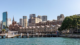
The Rocks is a suburb, tourist precinct and historic area of Sydney's city centre, in the state of New South Wales, Australia. It is located on the southern shore of Sydney Harbour, immediately north-west of the Sydney central business district.

<span class="mw-page-title-main">Pitt Street</span> Street in Sydney, Australia

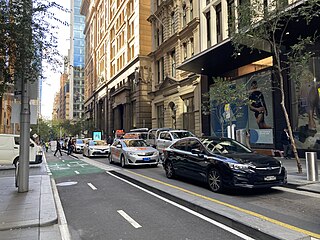
Pitt Street is a major street in the Sydney central business district in New South Wales, Australia. The street runs through the entire city centre from Circular Quay in the north to Waterloo, although today's street is in two disjointed sections after a substantial stretch of it was removed to make way for Sydney's Central railway station. Pitt Street is well known for the pedestrian only retail centre of Pitt Street Mall, a section of the street which runs from King Street to Market Street.

<span class="mw-page-title-main">Ultimo, New South Wales</span> Suburb of Sydney, New South Wales, Australia

Ultimo is an inner-city suburb of Sydney, New South Wales, Australia. It is adjacent to the Sydney central business district in the local government area of the City of Sydney west of the Darling Harbour area, and is bordered by Pyrmont to the north, the Sydney CBD and Chinatown/Haymarket to the east, Broadway and Chippendale to the south, and Glebe and Wentworth Park to the west.

<span class="mw-page-title-main">Berrima, New South Wales</span> Town in New South Wales, Australia

Berrima is a historic village in the Southern Highlands of New South Wales, Australia, in Wingecarribee Shire. The village, once a major town, is located on the Old Hume Highway between Sydney and Canberra. It was previously known officially as the Town of Berrima. It is close to the three major towns of the Southern Highlands: Mittagong, Bowral and Moss Vale.

<span class="mw-page-title-main">Millers Point, New South Wales</span> Suburb of Sydney, New South Wales

Millers Point is an inner-city suburb of Sydney, in the state of New South Wales, Australia. It is on the north-western edge of the Sydney central business district, adjacent to The Rocks and is part of the local government area of the City of Sydney.

Cleveland Street is a busy thoroughfare located to the south of the central business district of Sydney in New South Wales, Australia. The street is named after Captain Cleveland, an officer of the 73rd regiment.

East Maitland is a suburb in Maitland, New South Wales, Australia. It is on the New England Highway and it has two railway stations, Victoria Street and East Maitland. Both stations are served by NSW TrainLink. Hunter Valley Buses provides bus service.

<span class="mw-page-title-main">Mortimer Lewis</span> English-born architect, surveyor and public servant

Mortimer William Lewis was an English-born architect, surveyor and public servant who migrated to Australia and became Colonial Architect in the colony of New South Wales from 1835 to 1849. Lewis was responsible for designing and overseeing many government buildings in Sydney and rural New South Wales, many of which are heritage listed.

<span class="mw-page-title-main">Albion Street, Surry Hills</span> Street in Sydney, Australia

Albion Street is a street in Sydney, New South Wales, Australia in the local government area of the City of Sydney. It runs east-west from Elizabeth Street to Flinders Street, and is approximately one kilometre long.

<span class="mw-page-title-main">St Michael's Anglican Church, Surry Hills</span> Church in New South Wales, Australia

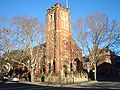
The St Michael's Anglican Church is a church in the Sydney suburb of Surry Hills. It is located on the corner of Albion and Flinders Street and together with the adjoining rectory and parish hall it is listed on the Register of the National Estate. In 2015 the church merged with Vine Church, which was an Anglican church plant that had started in Surry Hills in 2011. In 2017, the church changed its name to Vine Church to reflect the renewal the church has undergone and vision of connecting people to the life, love and freedom Jesus offers.

<span class="mw-page-title-main">197, 199, 201 Albion Street, Surry Hills</span> Historic site in New South Wales, Australia

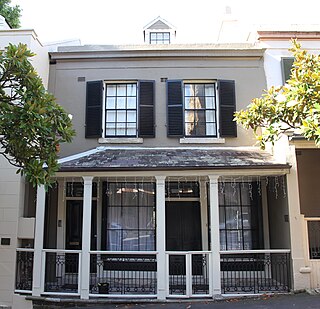
197, 199, 201 Albion Street terrace cottages are three heritage-listed terraced houses located at 197, 199, 201 Albion Street in the inner city Sydney suburb of Surry Hills in the City of Sydney local government area of New South Wales, Australia. It was added to the New South Wales State Heritage Register on 2 April 1999.

<span class="mw-page-title-main">Crown Street Public School</span> School

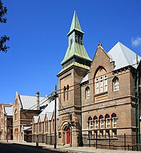
The Crown Street Public School is a heritage-listed public primary school located at Crown Street, Surry Hills, City of Sydney, New South Wales, Australia. It was designed by George Allen Mansfield and built from in 1869 by A. Scott, Mackay and Son. It was added to the New South Wales State Heritage Register on 2 April 1999.

<span class="mw-page-title-main">Bourke Street Wesleyan Chapel</span> Historic site in New South Wales, Australia

Bourke Street Wesleyan Chapel is a heritage-listed chapel at 348a Bourke Street in the inner city Sydney suburb of Darlinghurst in the City of Sydney local government area of New South Wales, Australia. The property is owned by the Wesleyan Church. It was added to the New South Wales State Heritage Register on 2 April 1999. It was also known as the Bourke Street Methodist Church.

<span class="mw-page-title-main">82-84 Windmill Street, Millers Point</span> Historic site in New South Wales, Australia

82–84 Windmill Street, Millers Point is a heritage-listed residence and former residence and office located at 82–84 Windmill Street, in the inner city Sydney suburb of Millers Point in the City of Sydney local government area of New South Wales, Australia. It is also known as the Royal College of Pathologists (former) and Terrace. It was added to the New South Wales State Heritage Register on 2 April 1999.

<span class="mw-page-title-main">Crown Hotel, Sydney</span> Heritage-listed hotel in Sydney, Australia

Crown Hotel is a heritage-listed hotel at 160–162 Elizabeth Street, Sydney, City of Sydney, New South Wales, Australia. It was added to the New South Wales State Heritage Register on 2 April 1999.

<span class="mw-page-title-main">St Sophia Greek Orthodox Church, Surry Hills</span> Church in New South Wales, Australia

St Sophia Greek Orthodox Church, officially the St Sophia and Her Three Daughters Greek Orthodox Church, is a heritage-listed Greek Orthodox church at 411a Bourke Street in the inner city Sydney suburb of Surry Hills in the City of Sydney local government area of New South Wales, Australia. Formerly a Congregational church, the building is also known as the former Bourke Street Congregational Church and School. It was added to the New South Wales State Heritage Register on 2 April 1999.

References

  1. Australian Bureau of Statistics (28 June 2022). "Surry Hills (suburb and locality)". Australian Census 2021 QuickStats. Retrieved 28 June 2022.  OOjs UI icon edit-ltr-progressive.svg
  2. Gregory's Sydney Street Directory, Gregory's Publishing Company, 2002, Map 19
  3. Butler, Katelin; Bruhn, Cameron (2017). The Apartment House. Thames & Hudson. p. 102. ISBN   978-0-500-50104-7.
  4. The Book of Sydney Suburbs, Frances Pollon, Angus & Robertson, 1990, p. 249 ISBN   0-207-14495-8
  5. Book of Sydney Suburbs, p. 249
  6. Jackson, Sally. "Patineur Grotesque". Australian Screen Online . National Film and Sound Archive of Australia . Retrieved 17 October 2020.
  7. Christopher Keating. "Surry Hills, The City's Backyard". Halstead Press, Australia. 1991 ( ISBN   9781920831493)
  8. David R. Keenan. CITY LINES of the Sydney Tramway System. Transit Press Australia,1991. ( ISBN   0646064452)
  9. "Surry Hills Markets website". shnc.org. Retrieved 8 April 2018.
  10. "Surry Hills Festival 2014 website". surryhillsfestival.com. Retrieved 8 April 2018.
  11. "Surry Hills Library and community centre upgrade". City of Sydney. Retrieved 11 March 2023.
  12. About Sydney Light Rail
  13. Sydney light rail opening delayed another two months to May 2020, Sydney Morning Herald , 4 October 2018
  14. Surry Hills businesses count the toll of light rail construction, Daily Telegraph , 2 February 2017
  15. "Untitled Document". www.surryhills.anglican.asn.au. Retrieved 8 April 2018.
  16. "Vine Church – Surry Hills, Sydney" . Retrieved 11 March 2023.
  17. "Sydney Police Centre location map". nsw.gov.au. Retrieved 8 April 2018.
  18. "Surry Hills Takeaway and Surry Hills Food Delivery, Sydney - Menulog". www.menulog.com.au. Retrieved 8 April 2018.
  19. Sydney Morning Herald Good Food Guide
  20. "Terrace Cottages". New South Wales State Heritage Register . Department of Planning & Environment. H00064. Retrieved 18 May 2018. CC BY icon.svg Text is licensed by State of New South Wales (Department of Planning and Environment) under CC-BY 4.0 licence .
  21. "Cottage". New South Wales State Heritage Register . Department of Planning & Environment. H00443. Retrieved 18 May 2018. CC BY icon.svg Text is licensed by State of New South Wales (Department of Planning and Environment) under CC-BY 4.0 licence .
  22. "Durham Hall". New South Wales State Heritage Register . Department of Planning & Environment. H00221. Retrieved 18 May 2018. CC BY icon.svg Text is licensed by State of New South Wales (Department of Planning and Environment) under CC-BY 4.0 licence .
  23. "Holy Trinity Greek Orthodox Church". New South Wales State Heritage Register . Department of Planning & Environment. H01816. Retrieved 18 May 2018. CC BY icon.svg Text is licensed by State of New South Wales (Department of Planning and Environment) under CC-BY 4.0 licence .
  24. "Busby's Bore". New South Wales State Heritage Register . Department of Planning & Environment. H00568. Retrieved 18 May 2018. CC BY icon.svg Text is licensed by State of New South Wales (Department of Planning and Environment) under CC-BY 4.0 licence .
  25. "Railway Institute Building". New South Wales State Heritage Register . Department of Planning & Environment. H01257. Retrieved 18 May 2018. CC BY icon.svg Text is licensed by State of New South Wales (Department of Planning and Environment) under CC-BY 4.0 licence .
  26. "Cleveland House". New South Wales State Heritage Register . Department of Planning & Environment. H00065. Retrieved 18 May 2018. CC BY icon.svg Text is licensed by State of New South Wales (Department of Planning and Environment) under CC-BY 4.0 licence .
  27. "Crown Street Public School". New South Wales State Heritage Register . Department of Planning & Environment. H00562. Retrieved 18 May 2018. CC BY icon.svg Text is licensed by State of New South Wales (Department of Planning and Environment) under CC-BY 4.0 licence .
  28. "Crown Street Reservoir & Site". New South Wales State Heritage Register . Department of Planning & Environment. H01323. Retrieved 18 May 2018. CC BY icon.svg Text is licensed by State of New South Wales (Department of Planning and Environment) under CC-BY 4.0 licence .
  29. "Hopetoun Hotel including Interior". New South Wales State Heritage Register . Department of Planning & Environment . Retrieved 17 January 2021. CC BY icon.svg Text is licensed by State of New South Wales (Department of Planning and Environment) under CC-BY 4.0 licence .
  30. The Heritage of Australia, Macmillan Company, 1981, p.2/88
  31. "Bourke Street Public School - Home". www.bourkest-p.schools.nsw.edu.au. Retrieved 8 April 2018.
  32. "Former Children's Court Building, Including Interior". New South Wales Heritage Database. Office of Environment & Heritage . Retrieved 8 April 2018.
  33. "Society of Friends (Quaker) Meeting House Including Fence and Interior". New South Wales Heritage Database. Office of Environment & Heritage . Retrieved 8 April 2018.
  34. "Former St David's Church Group Church and Residence Including Interiors". New South Wales Heritage Database. Office of Environment & Heritage . Retrieved 8 April 2018.
  35. 1 2 3 4 Australian Bureau of Statistics (28 June 2022). "Surry Hills". 2021 Census QuickStats. Retrieved 3 December 2022. OOjs UI icon edit-ltr-progressive.svg
  36. Australian Bureau of Statistics (27 June 2017). "Surry Hills". 2016 Census QuickStats. Retrieved 3 December 2022. OOjs UI icon edit-ltr-progressive.svg
  37. Keating, Chris (21 June 2009). "Surry Hills". p. 114. Retrieved 22 January 2018.

Further reading