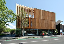
City of Sydney Library

Last updated

City of Sydney Library
SydneyCustomsHouse gobeirne.jpg
Customs House Library Branch
City of Sydney Library
Location Sydney, Australia
Established1909
Branches9
Collection
Size400,000 books
Other information
Website library.cityofsydney.nsw.gov.au

The City of Sydney Library network consists of nine branch libraries and two 'library links', located in Australia within the City of Sydney Council administrational area.

Contents

History

A free public lending library service has existed in Sydney since 1877 when the Government of New South Wales opened a lending branch of the State Library of New South Wales on Macquarie Street. By the end of the same year there were over one thousand registered borrowers. In 1899 the lending library moved to the second floor of the Queen Victoria Building and in 1909 control passed from State to the City of Sydney Council. In 1918 the library moved again, this time to the old concert hall of the Queen Victoria Building. This provided space for a separate children's library to open in the same year. The first branch libraries opened in 1949 which also provided book deposit stations at a number of local schools. In 1970, the City library moved to yet larger premises within the Queen Victoria Building before taking up residence at 321 Pitt Street in 1984. High rent fees prompted it to move again in 1994 to Town Hall House. In 2005 the Town Hall branch moved to its current location at Customs House at Circular Quay.

Locations

Green Square Library City of Sydney, Green Square Library entrance.jpg
Green Square Library
Surry Hills Library Branch Surry Hills Library 2010.jpg
Surry Hills Library Branch
Waterloo Library Branch Waterloo Town Hall.JPG
Waterloo Library Branch
Darling Square Library, Haymarket Darling Square Sydney.jpg
Darling Square Library, Haymarket

Library Link

Collections and services

In addition to the network's collection of over 400,000 books the libraries provide for the loan of CDs, DVDs, magazines, newspapers, toys and non-English books. The libraries also provide internet, copying and printing services.

In the Sydney Subject Specialisation Scheme, a Sydney-wide collection development policy which facilitated interlibrary loans prior to computerised union catalogues, the City of Sydney Library maintained a focus on life sciences, engineering and French literature. [2]

The City of Sydney library had a total stock of 461,253 items as of June 2015. [3]

A Library Link has existed in Town Hall House, close to the location of the library's previous premises, since its relocation to Customs House in 2005. The Library Link makes available a number of current newspapers and magazines, a fiction collection, a self-operated check-in and check-out machine and a telephone to contact library staff. Members can pick up books and other material held at other branches at the Library Link by contacting staff. In 2006 a link opened at Pyrmont offering a limited services. People are able to drop off books and pick up items they have asked for during the time that the volunteers are there.

Membership

The library network has around 40,000 active members and processes 1,350,000 loans per year. [4] Membership of the library network is free to residents of the City of Sydney local government area and residents of New South Wales.

Related Research Articles

<span class="mw-page-title-main">Newtown, New South Wales</span> Suburb of Sydney, New South Wales, Australia

Newtown, a suburb of Sydney's inner west, is located approximately four kilometres south-west of the Sydney central business district, straddling the local government areas of the City of Sydney and Inner West Council in the state of New South Wales, Australia.

<span class="mw-page-title-main">Haymarket, New South Wales</span> Suburb of Sydney, New South Wales

Haymarket is an inner city suburb of Sydney, New South Wales, Australia. It is located at the southern end of the Sydney central business district in the local government area of the City of Sydney. Haymarket includes much of Sydney's Chinatown, Thaitown and Railway Square localities. Haymarket is adjacent to Darling Harbour and is surrounded by the suburbs of Ultimo, Chippendale, Surry Hills and the Sydney CBD.

<span class="mw-page-title-main">Surry Hills, New South Wales</span> Suburb of Sydney, New South Wales, Australia

Surry Hills is an inner-east suburb of Sydney, in the state of New South Wales, Australia. Surry Hills is immediately south-east of the Sydney central business district in the local government area of the City of Sydney. Surry Hills is surrounded by the suburbs of Darlinghurst to the north, Chippendale and Haymarket to the west, Moore Park and Paddington to the east and Redfern to the south. It is often colloquially referred to as "Surry".

<span class="mw-page-title-main">Chinatown, Sydney</span> Place in New South Wales, Australia

Chinatown is an urban enclave situated in the southern part of the Sydney central business district, in New South Wales, Australia. It comprises the majority of the Haymarket suburb, between Central station and Darling Harbour. It is part of the local government area of the City of Sydney, and is Australia's largest Chinatown.

<span class="mw-page-title-main">Glebe, New South Wales</span> Suburb of Sydney, New South Wales, Australia

Glebe is an inner-western suburb of Sydney in New South Wales. Glebe is located 3 kilometres (1.9 mi) southwest of the Sydney central business district and is part of the local government area of the City of Sydney, in the Inner West region.

<span class="mw-page-title-main">Pyrmont, New South Wales</span> Suburb of Sydney, New South Wales, Australia

Pyrmont is an inner-city suburb of Sydney, in the state of New South Wales, Australia 2 kilometres south-west of the Sydney central business district in the local government area of the City of Sydney. It is also part of the Darling Harbour region. As of 2011, it is Australia's most densely populated suburb.

<span class="mw-page-title-main">Glebe Point Road</span> Road in Sydney, Australia

Glebe Point Road is the main road of the inner city suburb of Glebe in Sydney, New South Wales, Australia. It is a boutique shopping strip with numerous restaurants and cafés.

<span class="mw-page-title-main">Ultimo, New South Wales</span> Suburb of Sydney, New South Wales, Australia

Ultimo is an inner-city suburb of Sydney, New South Wales, Australia.

<span class="mw-page-title-main">Glebe Island Bridge</span> Swing Allan truss road bridge in Sydney, Australia

The Glebe Island Bridge is a heritage-listed disused swing Allan truss road bridge that carried Victoria Road across Rozelle Bay, located in the inner city Sydney suburb of Pyrmont in the City of Sydney local government area of New South Wales, Australia. The bridge, that connected Rozelle to Pyrmont by road, is one of the last remaining swing bridges of its type in Australia and in the world. It was designed by Percy Allan and built from 1899 to 1903 by Bridges Branch of NSW Public Works Department. It is also known as RMS Bridge No. 61. It was added to the New South Wales State Heritage Register on 29 November 2013 and was listed on the Register of the National Estate on 19 April 1989.

The Division of West Sydney was an Australian electoral division in the state of New South Wales. It was located in the inner western suburbs of Sydney, and at various times included the suburbs of Pyrmont, Darling Harbour, Surry Hills, Balmain, Glebe, and from 1955 to 1969, Lord Howe Island.

<span class="mw-page-title-main">Division of Sydney</span> Australian federal electoral division

The Division of Sydney is an Australian electoral division in the state of New South Wales.

<span class="mw-page-title-main">Trams in Sydney</span> History of the tramway system closed in Sydney NSW Australia

The Sydney tramway network served the inner suburbs of Sydney, Australia, from 1879 until 1961. In its heyday, it was the largest in Australia, the second largest in the Commonwealth of Nations, and one of the largest in the world. The network was heavily worked, with about 1,600 cars in service at any one time at its peak during the 1930s . Patronage peaked in 1945 at 405 million passenger journeys. Its maximum street trackage totalled 291 km in 1923.

<span class="mw-page-title-main">Western Distributor (Sydney)</span> Motorway in New South Wales, Australia

Western Distributor is a 4.3-kilometre-long (2.7 mi) grade-separated motorway that is primarily elevated for the majority of its route on the western fringe of the Sydney central business district in New South Wales, Australia. It links the southern end of Bradfield Highway at the Sydney Harbour Bridge to Victoria Road in Rozelle, at its western terminus near White Bay. It is a constituent part of the A4 route.

Australian non-residential architectural styles are a set of Australian architectural styles that apply to buildings used for purposes other than residence and have been around only since the first colonial government buildings of early European settlement of Australia in 1788.

<span class="mw-page-title-main">Market Street, Sydney</span> Street in Sydney, Australia

Market Street is a street in the city centre of Sydney in New South Wales, Australia. It runs from Sussex Street near Darling Harbour in the west, to Elizabeth Street at St James railway station in the east.

<span class="mw-page-title-main">Electoral district of Sydney</span> New South Wales state electoral division

Sydney is an electoral district of the Legislative Assembly of the Australian state of New South Wales in Inner Sydney. It includes the Sydney CBD; the suburbs and localities of Barangaroo, Broadway, Chinatown, Darling Harbour, Darlinghurst, Dawes Point, Elizabeth Bay, Haymarket, Millers Point, Paddington, Potts Point, Pyrmont, The Rocks, Woolloomooloo, Wynyard, Surry Hills, Rushcutters Bay; and parts of Ultimo.

George Allen Mansfield was a prominent Australian architect of the nineteenth century who designed many iconic buildings in Sydney, New South Wales, Australia.

<span class="mw-page-title-main">Ultimo Sewage Pumping Station</span> Historic site in New South Wales, Australia

The Ultimo Sewage Pumping Station is a heritage-listed sewerage pumping station located at William Henry Street in the inner city Sydney suburb of Ultimo in the City of Sydney local government area of New South Wales, Australia. As a result of the construction of an elevated roadway along William Henry Street, the pumping station now fronts Pyrmont Street, with vehicles being required to enter via Quarry Street, then turning right into Pyrmont Street.

<span class="mw-page-title-main">Urban renewal in Sydney</span> Ongoing land redevelopment of the new urban centres in Sydney, Australia

The urban renewal of Sydney is an ongoing land redevelopment process that is creating and reviving new urban centres across Sydney, Australia. Urban renewal refers to the refurbishment of derelict buildings, streets or neighbourhoods and is accompanied with the process of gentrification attributed by changes in land use and deindustrialisation of areas. In 2020, there are several projects underway and planned including Barangaroo, The Bays Precinct and Green Square.

References

  1. "Green Square Library - City of Sydney". www.cityofsydney.nsw.gov.au. Retrieved 18 June 2016.
  2. "Sydney Subject Specialisation Scheme". 17 November 2012.
  3. Morrison, Kathy. "PUBLIC LIBRARY STATISTICS 2014–15 PUBLIC LIBRARY SERVICES IN NEW SOUTH WALES" (PDF). State Library of NSW. p. 29. Retrieved 21 May 2017.
  4. City of Sydney Library Statistics (2004–06), retrieved 2009-10-07 Archived 2009-09-30 at the Wayback Machine

33°51′44″S151°12′39″E / 33.86219°S 151.21072°E / -33.86219; 151.21072