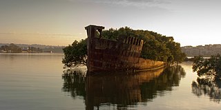
Homebush Bay is a bay on the south bank of the Parramatta River, in the west of Sydney, Australia. The name is also sometimes used to refer to an area to the west and south of the bay itself, which was formerly an official suburb of Sydney, and has now become the suburbs of Sydney Olympic Park, Wentworth Point and part of the neighbouring suburb of Lidcombe, all part of the City of Parramatta. Homebush Bay is located 16 kilometres (9.9 mi) west of the Sydney central business district.

North Sydney is a suburb and major commercial district on the Lower North Shore of Sydney, Australia. North Sydney is located 3 kilometres north of the Sydney central business district and is the administrative centre for the local government area of North Sydney Council.
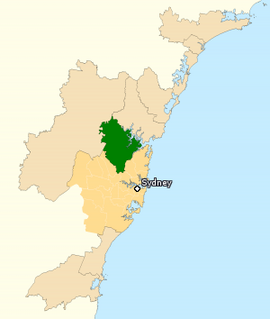
The Division of Berowra is an Australian electoral division in the state of New South Wales.
Dundas is a suburb of Sydney, New South Wales, Australia. Dundas is located 21 kilometres north-west of the Sydney central business district, in the local government area of the City of Parramatta, and the electoral division of Bennelong. Dundas is a leafy green suburb, notably due to its centrepiece The Ponds Walk, which follows the Ponds Subiaco Creek. Dundas is part of the Northern Sydney and Greater Western Sydney regions.

Canterbury is a suburb extending across south-western Sydney and the Inner West, in the state of New South Wales, Australia. Canterbury is located 10.5 kilometres (6.5 mi) south-west of the Sydney central business district in the City of Canterbury-Bankstown.

Berowra is an outer suburb of Northern Sydney located in the state of New South Wales, Australia 36 kilometres north of the Sydney central business district, in the local government area of Hornsby Shire. Berowra is south-east of the suburbs of Berowra Heights and east of Berowra Waters. The name Berowra means place of many shells, referring to the many shell middens on Berowra Creek.

Mount Colah is an outer suburb of Northern Sydney, in the state of New South Wales, Australia 29 kilometres north of the Sydney central business district, in the local government area of Hornsby Shire. Mount Colah is often referred to as "Far Northern" or Upper North Shore.

Woolwich is a suburb on the Lower North Shore of Sydney, in the state of New South Wales, Australia. Woolwich is located 11 kilometres north-west of the Sydney central business district, in the local government area of the Municipality of Hunter's Hill. Woolwich sits on the peninsula between the Lane Cove River and the Parramatta River, jutting out from Hunters Hill.
Mount Kuring-gai is an outer suburb of Northern Sydney, in the state of New South Wales, Australia. Mount Kuring-gai is located 31 kilometres north-west of the Sydney central business district, in the local government area of Hornsby Shire. Mount Kuring-Gai is often referred to as “Far Northern” or Upper North Shore.
Berowra Heights is an outer suburb of Northern Sydney, in the state of New South Wales, Australia 39 kilometres north of the Sydney central business district, in the local government area of Hornsby Shire. Berowra Heights is north-west of the suburb of Berowra and east of Berowra Waters.

Chatswood West is a suburb on the Lower North Shore of Sydney, in the state of New South Wales, Australia. Chatswood West is located 11 kilometres north-west of the Sydney central business district, in the local government areas of the City of Willoughby and City of Ryde. Chatswood is a separate suburb. The area of Chatswood located west of the Pacific Highway is informally known as West Chatswood, which should not be confused with the separate suburb of Chatswood West, nor should it be confused with the West Chatswood Post Office on Railway Street in the suburb of Chatswood. Chatswood West shares the same postcode as Chatswood which is 2067.

Hornsby Heights is a suburb of Northern Sydney, in the state of New South Wales, Australia. Hornsby Heights is located 26 kilometres north-west of the Sydney central business district, in the local government area of Hornsby Shire. The suburb is often referred to as part of the Upper North Shore.

Huntleys Point is a suburb on the Lower North Shore of Sydney, in the state of New South Wales, Australia. Huntleys Point is located nine kilometres north-west of the Sydney central business district, in the local government area of the Municipality of Hunter's Hill. Huntleys Point sits on the northern shore of the Parramatta River.

Wisemans Ferry is a cable ferry across the Hawkesbury River in New South Wales, Australia. The ferry operates from the eponymous community of Wisemans Ferry on the south bank, to a point on the north bank downstream of the Hawkesbury River's confluence with the Macdonald River, connecting with the old Great North Road. The crossing has remained in use on its current site since 1829, making it the oldest ferry crossing still in operation in New South Wales, and possibly in Australia.

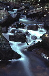
The Berowra Creek, a watercourse that is part of the Hawkesbury-Nepean catchment, is located to the north of the Sydney central business district in the Hornsby Shire of New South Wales, Australia.
The Mortlake Ferry, also known as the Putney Punt, is a cable ferry that runs across the Parramatta River in Sydney, connecting Hilly Street in Mortlake and Pellisier Road in Putney.

The Sackville Ferry is a cable ferry across the Hawkesbury River in New South Wales, Australia. The ferry connects the communities of Sackville, on the north/west bank of the river, and Sackville North, on the south/east bank. Because of the tortuous course of the river, the ferry actually runs north-west from Sackville to Sackville North.

Webbs Creek Ferry is a cable ferry across the Hawkesbury River in New South Wales, Australia. The ferry operates from the community of Wisemans Ferry, to a point up-stream of the Hawkesbury River's confluence with the Macdonald River, thus connecting with St Albans Road that follows the west bank of the Macdonald River.
The Berowra Waters Ferry is a cable ferry across the Berowra Creek, a tributary of the Hawkesbury River, located in the Berowra Valley National Park in northern Sydney, New South Wales, Australia. The ferry operates from the community of Berowra Waters on the west bank of the creek, to a landing on the east bank, thus connecting with the road to Berowra Heights.

Lugarno is a suburb in the St George area of southern Sydney, in the state of New South Wales, Australia. It is located in the local government area of the Georges River Council, 23 kilometres south of the Sydney central business district.

