
Marramarra National Park is a protected national park that is located in the Hawkesbury region of northwestern Sydney, New South Wales, in eastern Australia. The 11,785-hectare (29,120-acre) national park is situated approximately 40 kilometres (25 mi) northwest of the Sydney central business district.

The Hawkesbury River, or Hawkesbury-Nepean River a river located northwest of Sydney, New South Wales, Australia. The Hawkesbury River and its associated main tributary, the Nepean River, almost encircle the metropolitan region of Sydney. Between Wisemans Ferry and the Pacific Ocean marks the boundary of Greater Metropolitan Sydney in the south and the Central Coast region to the north.

St Albans is a small and historic village on the Macdonald River, New South Wales, Australia, about 94 kilometres (65 mi) north west of Sydney. At the 2011 census, St Albans and the surrounding area had a population of 305 people.

The Hills Shire is a local government area in the Greater Sydney region of Sydney, New South Wales, Australia. The area is north-west of the Sydney central business district, and encompasses 401 square kilometres (155 sq mi) stretching from the M2 Hills Motorway in the south to Wisemans Ferry on the Hawkesbury River in the north. The Hills Shire had a population of 191,876 as of the 2021 census.

Hornsby Shire is a local government area situated on the Upper North Shore as well as parts of the Hills District, of Sydney in the state of New South Wales, Australia. The shire stretches from the M2 Hills Motorway in the south to the Hawkesbury River town of Wisemans Ferry, some 53 kilometres (33 mi) to the north, making it the largest local government council in the Greater Sydney Metropolitan region by total area. As of the 2016 census the shire had an estimated population of 142,667.
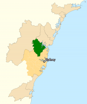
The Division of Berowra is an Australian electoral division in the state of New South Wales. The Division covers the northern parts of the Greater Sydney area with the local government areas of the Hornsby Shire and the Hills Shire.

Brooklyn is a suburb and the northern most town on the Pacific Highway in Sydney, New South Wales, Australia. Brooklyn is located on the northern outskirts of Sydney and is located in the local government area of the Hornsby Shire with a population of 737 as of the 2021 census. Brooklyn is surrounded by the Muogamarra Nature Reserve and occupies a strip of waterfront along the southern bank of the Hawkesbury River.

The Great North Road is a historic road that was built to link early Sydney, in the Colony of New South Wales, now Australia, with the fertile Hunter Valley to the north. Built by convicts between 1825 and 1836, it traverses over 260 kilometres (162 mi) of the rugged terrain that hindered early agricultural expansion.
Canoelands is a suburb of northern Sydney, in the state of New South Wales, Australia. Canoelands is 60 kilometres north of the Sydney central business district, in the local government area of Hornsby Shire and The Hills Shire.

South Maroota is a suburb in Sydney, New South Wales, Australia 72 kilometres north-west of the Sydney central business district in the local government area of The Hills Shire. The Hawkesbury River forms part of its western boundary.

Sackville North is a suburb of Sydney, in the state of New South Wales, Australia 80 kilometres north-west of the Sydney central business district in the local government area of The Hills Shire.

Cattai is an historic suburb of Sydney, in the state of New South Wales, Australia. It is located 44 kilometres north-west of the Sydney central business district and 30 kilometres north-west of Parramatta. It is in the local government areas of The Hills Shire and City of Hawkesbury. Cattai's state electoral district is Hawkesbury, and its federal electoral divisions are Berowra and Macquarie.

Wisemans Ferry is a town on the northern outskirts of Sydney and the south-west of the Central Coast region in the state of New South Wales, Australia, located 75 kilometres north north-west of Sydney. It is located in the Sydney local government areas of the Hornsby Shire, The Hills Shire, City of Hawkesbury and the Central Coast Council. The town is a tourist spot with picnic and barbecue facilities. As well as a rich convict and colonial heritage in the area, the Dharug National Park and Yengo National Park are close by.
Wisemans Ferry is a cable ferry across the Hawkesbury River in New South Wales, Australia. The ferry operates from the eponymous community of Wisemans Ferry on the south bank, to a point on the north bank downstream of the Hawkesbury River's confluence with the Macdonald River, connecting with the old Great North Road. The crossing has remained in use on its current site since 1829, making it the oldest ferry crossing still in operation in New South Wales, and possibly in Australia.

The Berowra Creek, a watercourse that is part of the Hawkesbury-Nepean catchment, is located to the north of the Sydney central business district in the Hornsby Shire of New South Wales, Australia.
The Muogamarra Nature Reserve is a protected nature reserve that is located in the Sydney region of New South Wales, in eastern Australia. The 2,274-hectare (5,620-acre) reserve is situated in the northern edge of Sydney and lies between the suburb of Cowan to the south, and the Hawkesbury River to the north.

Dangar Island is a forested island, 30.8 hectares in area, in the Hawkesbury River, on the northern outskirts of Sydney, New South Wales, Australia. Dangar Island is a suburb of Hornsby Shire and as at the 2021 census had a population of 313, which swells dramatically during holiday seasons. The island is serviced regularly by Brooklyn Ferry Service and departs from Brooklyn and takes about fifteen minutes. The Brooklyn ferry is itself adjacent to Hawkesbury River railway station. The ferry service is in operation 7 days a week.

The Sackville Ferry is a cable ferry across the Hawkesbury River in New South Wales, Australia. The vehicular ferry connects the communities of Sackville, on the north/west bank of the river, and Sackville North, on the south/east bank. Because of the tortuous course of the river, the ferry actually runs north-west from Sackville to Sackville North.
The Lower Portland Ferry is a cable ferry across the Hawkesbury River in New South Wales, Australia. The ferry is situated in the community of Lower Portland.
The Great Drain is a heritage-listed former farm and farm cottage and now motorcycle track, overnight accommodation and reserve located on the Wisemans Ferry Road, South Maroota in The Hills Shire local government area of New South Wales, Australia. It was built from 1795 to 1820 by probably by William Barren and William Harvey, stonemasons. It is also known as the Great Drain and two house sites. The property is owned by The Hills Shire Council and was added to the New South Wales State Heritage Register on 14 July 2000.
