
Hornsby is a suburb on the Upper North Shore of Sydney in the state of New South Wales, Australia, approximately 23 kilometres (14 mi) north-west of the Sydney central business district. It is the administrative centre of the local government area of Hornsby Shire.

The North Shore is a region within Northern Sydney, in New South Wales, Australia, generally referring to suburbs located on the northern side of Sydney Harbour up to Wahroonga, and suburbs between Middle Harbour and the Lane Cove River.

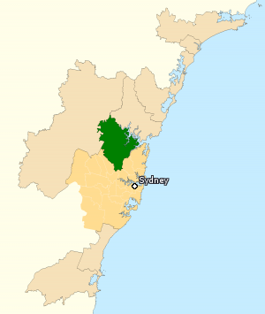
Hornsby Shire is a local government area situated on the Upper North Shore as well as parts of the Hills District, of Sydney in the state of New South Wales, Australia. The shire stretches from the M2 Hills Motorway in the south to the Hawkesbury River town of Wisemans Ferry, some 53 kilometres (33 mi) to the north, making it the largest local government council in the Greater Sydney Metropolitan region by total area. As of the 2016 census the shire had an estimated population of 142,667.

Waverton railway station is a heritage-listed railway station located on the North Shore line, serving the Sydney suburb of Waverton in New South Wales, Australia. It is served by Sydney Trains T1 North Shore line services. The station is located on Bay Road, Waverton, in the North Sydney Council local government area of New South Wales, Australia. It was designed and built by New South Wales Department of Railways. It is also known as Waverton Railway Station group. The station was added to the New South Wales State Heritage Register on 2 April 1999.
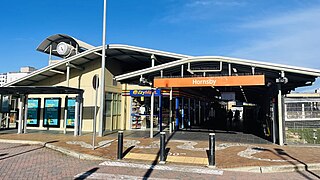
Hornsby railway station is a heritage-listed railway station located at the junction of the Main Northern and North Shore lines, serving the Sydney suburb of Hornsby. It is served by Sydney Trains' T1 North Shore Line and T9 Northern Line services and NSW TrainLink Intercity and regional services.
The Division of Berowra is an Australian electoral division in the state of New South Wales. The Division covers the northern parts of the Greater Sydney area with the local government areas of the Hornsby Shire and the Hills Shire.

Asquith is a suburb in Sydney's Northern Suburbs in the state of New South Wales, Australia. Asquith is located 26 km north-west of the Sydney central business district, in the local government area of Hornsby Shire. The suburb contains a section of Ku-ring-gai Chase National Park on its eastern side.
Westleigh is a suburb in the Upper North Shore region of Sydney in the state of New South Wales, Australia, 22 kilometres north-west of the Sydney central business district in the local government area of Hornsby Shire.

Brooklyn is a suburb and the northern most town on the Pacific Highway in Sydney, New South Wales, Australia. Brooklyn is located on the northern outskirts of Sydney and is located in the local government area of the Hornsby Shire with a population of 737 as of the 2021 census. Brooklyn is surrounded by the Muogamarra Nature Reserve and occupies a strip of waterfront along the southern bank of the Hawkesbury River.

Normanhurst is a suburb in the Upper North Shore region of Sydney in the state of New South Wales, Australia, 22 kilometres north-west of the Sydney central business district in the local government area of Hornsby Shire.
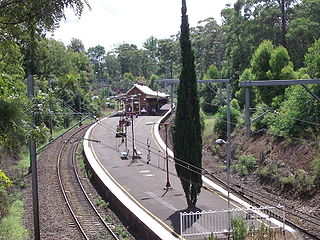
Thornleigh railway station is located on the Main Northern line, serving the Sydney suburb of Thornleigh. It is served by Sydney Trains' T9 Northern Line services.
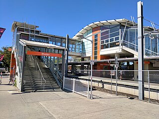
Rhodes railway station is a heritage-listed railway station located on the Main Northern line, serving the Sydney suburbs of Rhodes and Liberty Grove both in City of Canada Bay, Sydney, New South Wales, Australia. It is served by Sydney Trains' T9 Northern Line services.
Beecroft railway station is a heritage-listed railway station located on the Main Northern line, serving the Sydney suburb of Beecroft. It is served by Sydney Trains' T9 Northern Line services.

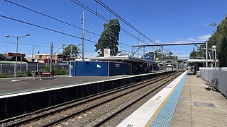
Normanhurst railway station is located on the Main Northern line, serving the Sydney suburb of Normanhurst. It is served by Sydney Trains' T9 Northern Line services.

Waitara is a suburb in the Upper North Shore region of Sydney, in the state of New South Wales, Australia 19 kilometres north-west of the Sydney central business district, in the local government area of Hornsby Shire.

Cowan is a small outer suburb of Sydney, in the state of New South Wales, Australia, approximately 40 kilometres (25 mi) north of the Sydney central business district, in the local government area of Hornsby Shire. Cowan shares the postcode of 2081 with Berowra. Brooklyn, which lies 6 kilometres (3.7 mi) to the north-east of Cowan, is considered the northernmost suburb of the Greater Sydney Metropolitan Area.

Pennant Hills Road is a 16.1-kilometre-long (10.0 mi) arterial road located in Sydney, New South Wales, Australia. The road links the suburb of Wahroonga in the northeast, to the major central business district of Parramatta in the southwest. Apart from a small section at its southwestern end, it is a constituent part of Cumberland Highway, and is designated part of route A28.

Dangar Island is a forested island, 30.8 hectares in area, in the Hawkesbury River, on the northern outskirts of Sydney, New South Wales, Australia. Dangar Island is a suburb of Hornsby Shire and as at the 2021 census had a population of 313, which swells dramatically during holiday seasons. The island is serviced regularly by Brooklyn Ferry Service and departs from Brooklyn and takes about fifteen minutes. The Brooklyn ferry is itself adjacent to Hawkesbury River railway station. The ferry service is in operation 7 days a week.

Northern Sydney is a large metropolitan area in Greater Sydney, New South Wales, Australia on the north shore of Sydney Harbour and Parramatta River. The region embraces suburbs in Sydney's north-east, north and inner north west. Northern Sydney is divided into distinctive regions such as the North Shore, Northern Beaches and Forest District.

Wahroonga is an electoral district of the Legislative Assembly in the Australian state of New South Wales. It was contested for the first time at the 2023 election.


