
Castle Hill is a suburb of Sydney, New South Wales, Australia, located 34 kilometres north-west of the Sydney central business district and 9.5 kilometres north of Parramatta. It is within the Hills District region, split between the local government areas of The Hills Shire and Hornsby Shire.

Hornsby is a suburb on the Upper North Shore of Sydney in the state of New South Wales, Australia, approximately 23 kilometres (14 mi) north-west of the Sydney central business district. It is the administrative centre of the local government area of Hornsby Shire.

Epping is a suburb of Sydney, in the Australian state of New South Wales, 18 kilometres north-west of the Sydney central business district in the local government area of the City of Parramatta. Epping is in the Northern Sydney region. The suburb is the most north-eastern area of the City of Parramatta. North Epping is a separate suburb to the north and under a different council, Hornsby Shire.
Dural is a semi rural suburb of Sydney, in the state of New South Wales, Australia 36 kilometres north-west of the Sydney central business district in the local government areas of Hornsby Shire and The Hills Shire. Dural is part of the Hills District. Round Corner is a locality in the south-western part of Dural.

Hornsby Shire is a local government area situated in Northern Sydney, as well as parts of the Hills District, in the state of New South Wales, Australia. The shire stretches from the M2 Hills Motorway in the south to the Hawkesbury River town of Wisemans Ferry, some 53 kilometres (33 mi) to the north, making it the largest local government council in the Greater Sydney Metropolitan region by total area. As of the 2016 census the shire had an estimated population of 142,667.

North Epping is a suburb of Sydney, in the state of New South Wales, Australia 19 kilometres north-west of the Sydney central business district in the local government area of Hornsby Shire. North Epping is in the Northern Sydney region, and is often referred to as part of the "North-West" or North Shore. Epping is a separate suburb to the south and under the Parramatta City Council, which shares the postcode of 2121.
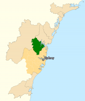
The Division of Berowra is an Australian electoral division in the state of New South Wales. The Division covers the northern parts of the Greater Sydney area with the local government areas of the Hornsby Shire and the Hills Shire.

Asquith is an outer suburb of Northern Sydney in the state of New South Wales, Australia. Asquith is located 26 km north-west of the Sydney central business district, in the local government area of Hornsby Shire. The suburb contains a section of Ku-ring-gai Chase National Park on its eastern side.
Westleigh is a suburb in the Northern Sydney region of Sydney in the state of New South Wales, Australia, 22 kilometres north-west of the Sydney central business district in the local government area of Hornsby Shire.
Cherrybrook is a suburb of Sydney, in the state of New South Wales, Australia 29 kilometres north-west of the Sydney central business district in the local government area of Hornsby Shire. Cherrybrook is often referred to as being located in the Hills District of Sydney.
Beecroft is a suburb in the Northern Sydney region of Sydney, in the state of New South Wales, Australia 22 kilometres north-west of the Sydney central business district in the local government areas of Hornsby Shire and City of Parramatta.

Normanhurst is a suburb in the Northern Sydney region of Sydney in the state of New South Wales, Australia, 22 kilometres north-west of the Sydney central business district in the local government area of Hornsby Shire.

West Pennant Hills is a suburb in the Hills District of Sydney, New South Wales, Australia. West Pennant Hills is located 21 km north-west of the Sydney central business district in the local government areas of The Hills Shire and Hornsby Shire.

Mount Colah is an outer suburb of Northern Sydney, in the state of New South Wales, Australia 24 kilometres north of the Sydney central business district, in the local government area of Hornsby Shire.

Galston is a semi-rural town located in the Hornsby District of Sydney, in the state of New South Wales, Australia. Galston is located from the city at 36 kilometres north-west of the Sydney central business district, in the local government area of the Hornsby Shire. Galston is in the NSW state electoral district of Hornsby and Federal division of Berowra. Galston is situated 16 minutes away from the suburb of Hornsby.
Middle Dural is a semi-rural suburb of Sydney, in the state of New South Wales, Australia 37 kilometres north-west of the Sydney central business district in the local government areas of Hornsby Shire and The Hills Shire. Dural is a separate suburb to the south.
Glenorie is a rural suburb of Sydney, in the state of New South Wales, Australia, 44 kilometres north-west of the Sydney central business district in the local government areas of The Hills Shire and Hornsby Shire. Glenorie is part of the Hills District.
Berowra Heights is an outer suburb of Northern Sydney, in the state of New South Wales, Australia 39 kilometres north of the Sydney central business district, in the local government area of Hornsby Shire. Berowra Heights is north-west of the suburb of Berowra and east of Berowra Waters.

Hornsby Heights is a suburb of Northern Sydney, in the state of New South Wales, Australia. Hornsby Heights is located 26 kilometres north-west of the Sydney central business district, in the local government area of Hornsby Shire. The suburb is often referred to as part of the Upper North Shore.
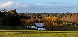
Fagan Park is a large recreational area located in Galston, a semi-rural area in Sydney, New South Wales, Australia. The park has been managed by Hornsby Shire since its opening in 1988, and covers an area of 55 hectares. The land that is now the park was home to the Fagan family until 1980, when Bruce Fagan and his sister, Ida, donated the land to the New South Wales State Government. Hornsby Shire Council was appointed sole trustee. The park was officially opened by the Premier of New South Wales, Nick Greiner, MP on 5 November 1988.
