Norwest, New South Wales

Last updated

Norwest
Sydney,  New South Wales
Norwest Lake from Boardwalk.jpg
Panorama of Norwest Lake in July 2018
Location map Australia Sydney.png
Red pog.svg
Norwest
Norwest, New South Wales
Coordinates 33°43′59″S150°57′49″E / 33.73306°S 150.96361°E / -33.73306; 150.96361
Population4,688 (SAL 2021) [1]
Established2018
Postcode(s) 2153
Elevation92 m (302 ft)
LGA(s) The Hills Shire
State electorate(s) Kellyville
Federal division(s) Mitchell
Suburbs around Norwest:
Bella Vista Kellyville Castle Hill
Bella Vista Norwest Castle Hill
Bella Vista Baulkham Hills Castle Hill
Norwest Business Park BellaVistaNSWnorwest.jpg
Norwest Business Park

Norwest is a suburb of the Hills District within Greater Western Sydney, in the state of New South Wales, Australia, located 35 kilometres north-west of the Sydney central business district. The Norwest Business Park is located within Norwest and the adjacent suburb of Bella Vista and Baulkham Hills. The council chambers for The Hills Shire Council are also located within this suburb.

Contents

History

Norwest was officially proclaimed a suburb on 29 June 2018. [2] Previously, it had been part of the older suburbs of Baulkham Hills and Kellyville.

The Geographical Names Board, in June 2018, amended the suburb boundaries of Kellyville, Baulkham Hills, Bella Vista and Rouse Hill resulting in the creation of two new suburbs named North Kellyville and Norwest. [3]

From 2018 to 2019, in preparation for the Norwest metro station which opened in May 2019, Norwest underwent an urban transformation, building up apartments and commercial retail stores around Norwest Lake, while also transforming what was previously "Coles Norwest" into Norwest Marketown.

Commercial areas

Norwest Marketown is a shopping centre featuring a Coles and dozens of specialty stores including McDonald's, Subway, Mad Mex, Oporto, El Jannah, Joey's Pizza & Pasta, small electronic and clothing stores, banks, restaurants and a day care centre.

Residential areas

Norwest features two main residential areas along boundaries of the suburb. Within Norwest, there is a variety of housing including low density housing, townhouses and apartments. Most of the housing within Norwest is close to retail, employment, recreation and transport within the suburb and the neighbouring suburbs of Kellyville, Castle Hill and Baulkham Hills.

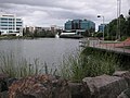
The area to the north of the suburb is part of the Balmoral Road release area and is within proximity of roads such as Fairway Drive, Stone Mason Drive and Spurway Drive. This area has a wide range from high rise apartments close to the lake to low density housing to the north of the golf course.

The area to the south of the suburb is located along Barina Downs Road and features mainly low density housing and townhouses, with one apartment complex

Transport

Road

Windsor Road connects Norwest to Baulkham Hills, Parramatta and Sydney from the eastern end of the suburb. Within the suburb, Norwest Boulevard connects Norwest with Bella Vista, the Westlink M7 and Old Windsor Road, which connects Norwest with other locations such as Penrith, Liverpool and Campbelltown.

Metro

Norwest Metro Station Dec 2019, Southern side (Brookhollow Ave) entry/exit Norwest Metro Station.jpg
Norwest Metro Station Dec 2019, Southern side (Brookhollow Ave) entry/exit

Norwest is serviced by Norwest Metro Station which is located on the Northwest line of the Sydney Metro. Opened in 2019, the station links Norwest to locations between Tallawong and Chatswood stations. The line will be extended by 2024 through the City and to Bankstown via the existing Bankstown railway line.

Buses

Norwest is serviced by multiple bus routes run by CDC NSW and Busways. These include:

Places of worship

The site of the first Hillsong church is located within Norwest, a megachurch which now has over 150,000 followers globally in over 30 countries, and 38 churches in Australia.

Related Research Articles

<span class="mw-page-title-main">Castle Hill, New South Wales</span> Town in New South Wales, Australia

Castle Hill is a town in Sydney, New South Wales, Australia, located 34 kilometres north-west of the Sydney central business district and 9.5 kilometres north of Parramatta. It is within the Hills District region, split between the local government areas of The Hills Shire and Hornsby Shire.

<span class="mw-page-title-main">The Hills Shire</span> Local government area in New South Wales, Australia

The Hills Shire is a local government area in the Greater Sydney region of Sydney, New South Wales, Australia. The area is north-west of the Sydney central business district, and encompasses 401 square kilometres (155 sq mi) stretching from the M2 Hills Motorway in the south to Wisemans Ferry on the Hawkesbury River in the north. The Hills Shire had a population of 191,876 as of the 2021 census.

<span class="mw-page-title-main">Hills District, New South Wales</span> Region in New South Wales, Australia

The Hills District is a region of Sydney, within the northern part of the Greater Western Sydney region of Sydney, in the state of New South Wales, Australia. Stretching from the M2 Hills Motorway in the south to the Hawkesbury River in the north and Old Windsor Road in the west to Pennant Hills Road and Berowra Creek in the east. The region is often considered to be synonymous with the local government area of The Hills Shire, however in a more expansive sense colloquial definitions can also include surrounding areas such as the western portion of the Hornsby Shire, as well as also sometimes including northern parts of City of Parramatta and Blacktown City Council.

<span class="mw-page-title-main">Bella Vista, New South Wales</span> Suburb of Sydney, New South Wales, Australia

Bella Vista is located 33 kilometres north-west of the Sydney central business district and is part of The Hills Shire. It is a suburb in the Hills District of Greater Western Sydney and is in the state of New South Wales, Australia. Bella Vista's Norwest Business Park is home to several Fortune 500 companies, a number of shopping centres, high-rise buildings, and industrial and recreational spaces.

<span class="mw-page-title-main">Baulkham Hills, New South Wales</span> Suburb of The Hills, New South Wales, Australia

Baulkham Hills is a suburb in the Hills District of Greater Sydney, in the state of New South Wales, Australia. It is located within 30 kilometres north-west of the Sydney central business district mostly within the local government area of The Hills Shire, of which Baulkham Hills was formerly the administrative seat and namesake of The Hills Shire. A small section of the suburb which is located south of the Hills Motorway-Windsor Road intersection is part of the City of Parramatta.

<span class="mw-page-title-main">Division of Mitchell</span> Australian federal electoral division

The Division of Mitchell is an Australian electoral division in the state of New South Wales.

<span class="mw-page-title-main">Parramatta railway station</span> Railway station in Sydney, New South Wales, Australia

Parramatta railway station is a heritage-listed railway station located on the Main Western line, serving Parramatta in New South Wales, Australia. It is served by Sydney Trains T1 Western Line, T2 Inner West & Leppington and T5 Cumberland Line services and NSW TrainLink Blue Mountains Line, Central West XPT and Outback Xplorer services.

Glenwood is a suburb of Sydney, in the state of New South Wales, Australia. Glenwood is located 33 kilometres north-west of the Sydney central business district in the local government area of the City of Blacktown and part of the Greater Western Sydney region.

<span class="mw-page-title-main">Kellyville Ridge, New South Wales</span> Suburb of Sydney, New South Wales, Australia

Kellyville Ridge is a suburb of Sydney, in the state of New South Wales, Australia. Kellyville Ridge is located 41 kilometres north-west of the Sydney central business district in the local government area of City of Blacktown. It is part of Greater Western Sydney.

<span class="mw-page-title-main">Kings Langley, New South Wales</span> Suburb of Sydney, New South Wales, Australia

Kings Langley is a suburb of Sydney, in the state of New South Wales, Australia. Kings Langley is located 28.3 kilometres north-west in a straight line from the Sydney central business district in the local government area of Blacktown City council.

<span class="mw-page-title-main">Stanhope Gardens, New South Wales</span> Suburb of Sydney, New South Wales, Australia

Stanhope Gardens is a suburb of Greater Western Sydney, in the state of New South Wales, Australia. Stanhope Gardens is located 31 kilometres north-west of the Sydney central business district in the local government area of City of Blacktown.

<span class="mw-page-title-main">Kellyville, New South Wales</span> Suburb of Sydney, New South Wales, Australia

Kellyville is a suburb of Sydney, in the state of New South Wales, Australia 36 kilometres north-west of the Sydney central business district in the local government area of The Hills Shire. It is part of the Hills District region.

Beaumont Hills is a suburb of Sydney, in the state of New South Wales, Australia 40 kilometres north west of the Sydney central business district, in the local government area of The Hills Shire. Beaumont Hills is part of the Greater Western Sydney region and the Hills District.

<span class="mw-page-title-main">Norwest Business Park</span>

The Norwest Business Park is a business park in the suburbs of Norwest and Bella Vista in the local government area of The Hills Shire in Sydney, New South Wales, Australia. Norwest Business Park is bordered by Windsor Road to the east, and Old Windsor Road to the west, with Norwest Boulevard stretching the length of the park between the two main arterial roads. Over 400 companies are located in the park, employing more than 25,000 people. The complex consists of a mix of commercial, professional and health-care services provided to the population of Sydney's Hills District.

The North-West T-way is a continuous series of bus-only lanes and bus roadways between Parramatta, Blacktown and Rouse Hill in Western Sydney. Opened in stages between March and November 2007, the 24 km (14.9 mi) T-way was the second bus rapid transit route to be built in Sydney after the Liverpool–Parramatta T-way.

<span class="mw-page-title-main">Sydney Metro Northwest</span> Rapid transit rail project in Sydney, New South Wales, Australia

Sydney Metro Northwest was a rapid transit project that constructed the first section of the Metro North West Line through the north-western suburbs of Sydney, New South Wales, Australia. The project included the conversion of the existing Epping to Chatswood rail link to metro standards and connects the suburbs of Rouse Hill and Chatswood via Castle Hill and Epping. The project was managed by Transport for NSW. The completed Metro North West Line opened on the 26 May 2019.

<span class="mw-page-title-main">Regions of Sydney</span> Overview article

The metropolis of Greater Sydney in New South Wales, Australia, is informally subdivided into a number of geographic regions. The geographical definition of Greater Sydney spans across 33 local government areas and includes the Blue Mountains in the west, the Northern Beaches and the Hawkesbury in the north, the Royal National Park, the Wollondilly and Macarthur in the south, and Botany Bay in the east. These areas sometimes, but not always, roughly coincide with official boundaries of suburbs, local government authorities, or cadastral units, and some of the customary regions do not have well defined boundaries at all. Some commonly referred to regions overlap: for example, Canterbury-Bankstown is often referred to as a region, but it is also part of the South Western Sydney region. The regions themselves are not used as a formal jurisdiction, and generally do not have administrative or legislative bodies, although some regions are coterminous with a local government area, and in a number of regions that include multiple local government areas, Regional Organisations of Councils have been established that represent the councils in the region.

North Kellyville is a suburb of Sydney, in the state of New South Wales, Australia. It is located 37 kilometres north-west of the Sydney central business district within the local government area of The Hills Shire. The suburb falls within the Hills District.

<span class="mw-page-title-main">Electoral district of Kellyville</span> Electoral district of the Legislative Assembly New South Wales, Australia

Kellyville is an electoral district of the Legislative Assembly in the Australian state of New South Wales. It was contested for the first time at the 2023 election.

References

  1. Australian Bureau of Statistics (28 June 2022). "Norwest (suburb and locality)". Australian Census 2021 QuickStats. Retrieved 28 June 2022.  OOjs UI icon edit-ltr-progressive.svg
  2. "Finalisation of suburb changes" (PDF). The Hills Shire Council. July 2018.
  3. "Government Gazette of NSW Number 66 Friday, 29 June 2018, see page 106" (PDF). Government Gazette of the state of New South Wales. 29 June 2018.

Suburb Changes – North Kellyville, Norwest & Bella Vista - Hills Shire