Fiddens Wharf

Last updated

Fiddens Wharf
Fiddens Wharf site.jpg
the site of Fiddens Wharf
Location Lane Cove National Park, Killara, Sydney, New South Wales, Australia
Coordinates 33°47′00″S151°08′41″E / 33.783283°S 151.144643°E / -33.783283; 151.144643 Coordinates: 33°47′00″S151°08′41″E / 33.783283°S 151.144643°E / -33.783283; 151.144643
Elevation5
Australia New South Wales relief location map.png
Red pog.svg
Location of Fiddens Wharf in New South Wales

Fiddens Wharf or Killara Wharf was a former wharf on the Lane Cove River in Sydney, Australia. Named after the convict Joseph Fidden, the wharf was primarily used for the transport of timber and supplies to and from Sydney in the 19th century. [1] [2] It is unknown whether the original structure was a conventional wharf, or a mooring place with lines connected to a metal ring secured in a nearby rock. Fiddens was one of the three main wharves on the river. [3]

Contents

Indigenous History

The local indigenous Australian people, the Cammeraygal occupied this area for at least 5,800 years. [4]

Early European History

In 1788, Captain Arthur Phillip was aware of timber resources on the north shore, in the area now known as Ku-ring-gai. By 1789 a detailed survey of the river up to De Burghs Bridge was made. Marine Lieutenant Ralph Clark explored the area in 1790. [5] In 1805 George Caley explored the area, finding stands of blackbutt and blue gum. The first Europeans to inhabit this area were convict timber cutters and their overseers, who set up camp around 1805 near the end of Fiddens Wharf Road. Sawpits, huts, a wharf and well were constructed. Between 1805 and 1809, a government sawmill and convict timber-getting camp was established on Lane Cove River near a place that is now known as “Fidden’s Wharf”. In 1814, 48 convicts and one overseer worked at the site. Even then, much of the best timber had been cut out. This site was disbanded about 1819. One of the early convict loggers was William Henry, known as "Loyal Henry". [6]

In the 1820s illegal timber workers set up camp at Fiddens Wharf. Described as "armed ruffians, murderers, cattle stealers, bushrangers and the very worst of characters". The logs were brought down to the wharf by bullock dray.

On 5 April 1821, Governor Lachlan Macquarie issued five crown grants of land in the area that now comprises Killara, which included 40 acres to Joseph Fidden. Over two decades much timber was cut, including blackbutt and ironbark, stringy bark and blue gum, the last two types highly regarded by Macquarie for building and flooring. Billy Blue was another boatman who traveled to the wharf. A track was formed by 1813, now known as Fiddens Wharf road. In 1831 it was recorded that three sheds and a garden were above Fiddens Wharf. Residents named were boatmen Joseph Fidden, Thomas Elyard and William Bowles. The Lane Cove Sawmill Company was established just up the hill on Fiddens Wharf Road. [1] [7]

Geography

A number of different plant communities were found near Fiddens Wharf. The early logging occurred in the Sydney Sandstone Gully Forest and Sydney Blue Gum High Forest. Soils in these forests are derived from Ashfield Shale and Hawkesbury Sandstone from the Triassic. In the Fiddens Wharf area Eocene alluvium and relatively high rainfall enabled large trees to grow. The Blackbutt is the predominant species. The dwarf plum pine is a common Gondwanan relict at the site today. Six and a half hectares of forest around Fiddens wharf was declared a wharf reserve, where no timber could be legally cut. Regular fire discouraged rainforest plant species and favoured the eucalyptus trees. Many large Blackbutt trees today remain in this area. [3]

Joseph Fidden

Joseph Fidden was born in Birmingham around 1778. [8] Though some references state his birth year was 1757. [2] Convicted at Kent Assizes in 1799 for burglary and stealing two pots of paint and two loaves of bread. Sentenced to death by hanging, which was commuted to seven years transportation. He arrived in Sydney Cove on the Earl Cornwallis on 6 June 1801. Fidden purchased his own land at Killara in 1821. Fidden gained his freedom and lived in the area for 25 years as a farmer and ferryman. He is said to have been a man of considerable strength [3] and rowed "tons of sawn timber with the tide down the river" to Circular Quay, and then "return with the tide, delivering supplies to farms along the way". On the return journey, he dropped off supplies to settlements upriver. The sly-grog and other products he provided attracted the rough-living sawyers and bushmen of the district. [9] [2] [7] In 1807 Fidden married Mary Clark at St John's Parramatta, they had four children. [10] He died on 17 April 1856. Buried in Camperdown Cemetery. [11] [2] [12]

After the logging

In the 1850s, when the local timber was exhausted, the area near Fiddens Wharf was planted with citrus trees. The fruit were sent to the city by boat for sale. Lane Cove Road became the main route for delivery to Sydney, [3] and the commercial importance of Fiddens wharf diminished. The citrus plantation failed due to soil deterioration, bushfires, pest and fungal disease. Fiddens Wharf eventually became a popular picnic spot. The cleared area near the river was an attractive area for recreation. Many boats from the city visited the area for day trips and camping. Vessels such as the "Native Rose", "Killara" and "Nellie" were often seen on the river. [9] [3]

20th century

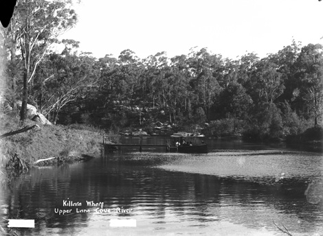
A new wharf was built in 1908. Picnics via flat bottomed boat to Fiddens Wharf continued in the 20th century, sometimes over 3,000 people per day traveled up river to Fiddens Wharf or Fairyland, downstream. Stone steps were built from the river to Fiddens Wharf road during the 1930s by unemployed men. They swam and fished by day. At night they distilled alcohol and gambled playing two up. Some slept under overhangs in the sandstone rocks. Their rock carvings may be seen today in rock ledges by the river bank. In 1937, a weir downstream of Fiddens Wharf was built on the river which stopped tidal boats from reaching Fiddens Wharf. In the summer of 1938-1939, 10,000 scouts from all over the world came to nearby Bradfield Park for the Australasian Scout Jamboree. The wharf area and river were prominent in their outdoor activities. During World War II, the nearby area uphill from the wharf was used by the air force. Wooden buildings were constructed near the wharf, and trenches were dug in the nearby hillside. A new wharf structure at the river was built by the air force at the site of the original wharf in the 1940s, for swimming and diving. The new wharf was 60 feet long with stairs and a pathway leading to an ablution block. [3] A sporting ground was built in 1966 near the wharf on the site of a small military training camp. This same area was used for logging purposes and picnics in the 19th century. [13]

21st Century

Practically no evidence of the wharf or the military remains today. Though some refuge material near the river may be part of the air force ablution block. Despite many years of bush regeneration, the area near Fiddens Wharf is infested with invasive weeds. Fiddens Wharf is on the Great North Walk. The oval is used for various activities such as football and cricket. [14] [13] [9]

Blackbutt trees & Fiddens Wharf oval Fiddens wharf oval.jpg
Blackbutt trees & Fiddens Wharf oval

Further reading

"Fiddens Wharf". Visit Sydney Australia.

Historical image

"Killara wharf at upper Lane Cove River". NSW State Archives- records.nsw.gov.au.

Related Research Articles

<span class="mw-page-title-main">Ku-ring-gai Chase National Park</span> Protected area in New South Wales, Australia

Ku-ring-gai Chase National Park is a national park on the northern side of Sydney in New South Wales, Australia. The 14,977-hectare (37,010-acre) park is 25 kilometres (16 mi) north of the Sydney central business district and generally comprises the land east of the M1 Pacific Motorway, south of the Hawkesbury River, west of Pittwater and north of Mona Vale Road. It includes Barrenjoey Headland on the eastern side of Pittwater.

<span class="mw-page-title-main">Lane Cove National Park</span> Protected area in New South Wales, Australia

The Lane Cove National Park is a protected national park that is located within metropolitan Sydney, in New South Wales, Australia. The 372-hectare (920-acre) national park is situated about 10 kilometres (6.2 mi) north-west of the Sydney central business district and features various vegetation types, such as, wet and dry sclerophyll forest, heathland, mangroves and tidal flats. The park consists of land near the banks of the Lane Cove River, which flows generally south-east into Sydney Harbour. It also extends to the outskirts of Pennant Hills and Wahroonga at its northern boundaries.

<span class="mw-page-title-main">Palm Beach, New South Wales</span> Suburb of Sydney, New South Wales, Australia

Palm Beach is a suburb in the Northern Beaches region of Sydney, in the state of New South Wales, Australia. Palm Beach is located 41 kilometres (25 mi) north of the Sydney central business district, in the local government area of Northern Beaches Council. Palm Beach sits on a peninsula at the end of Barrenjoey Road, between Pittwater and Broken Bay. The population of Palm Beach was 1,593 as at the 2016 census.

<span class="mw-page-title-main">Pymble, New South Wales</span> Suburb of Sydney, New South Wales, Australia

Pymble is a suburb on the Upper North Shore of Sydney in the state of New South Wales, Australia. Pymble is 15 kilometres (9 mi) north of the Sydney Central Business District in the local government area of Ku-ring-gai Council.

<span class="mw-page-title-main">Lindfield, New South Wales</span> Suburb of Sydney, New South Wales, Australia

Lindfield is a suburb on the Upper North Shore of Sydney in the state of New South Wales, Australia. It is 13 kilometres north-west of the Sydney Central Business District and is in the local government area of Ku-ring-gai Council. East Lindfield is a separate suburb to the east, sharing the postcode of 2070.

<span class="mw-page-title-main">Ku-ring-gai Council</span> Local government area in New South Wales, Australia

Ku-ring-gai Council is a local government area in Northern Sydney, in the state of New South Wales, Australia. The area is named after the Guringai Aboriginal people who were thought to be the traditional owners of the area. More contemporary research suggests that this was not the case.

<span class="mw-page-title-main">St Ives, New South Wales</span> Suburb of Sydney, New South Wales, Australia

St Ives is a suburb on the Upper North Shore of Sydney in the state of New South Wales, Australia 18 kilometres north of the Sydney Central Business District in the local government area of Ku-ring-gai Council. St Ives Chase is a separate adjacent area, designated suburb, to the west and north.

<span class="mw-page-title-main">North Shore (Sydney)</span> Region in New South Wales, Australia

The North Shore is a region within Northern Sydney, in the state of New South Wales, Australia, generally referring to suburbs located on the northern side of Sydney Harbour up to Wahroonga, and suburbs between Middle Harbour and the Lane Cove River.

<span class="mw-page-title-main">Lane Cove River</span> River in Sydney, Australia

The Lane Cove River, a northern tributary of the Parramatta River, is a tide-dominated, drowned valley estuary west of Sydney Harbour, located in Sydney, New South Wales, Australia. The river is a tributary of the Parramatta River, winding through a bushland valley. It joins Parramatta River at Greenwich and Woolwich, where together they form an arm of Sydney Harbour, and serves as a border along with Middle Harbour separating Sydney's North Shore.

<span class="mw-page-title-main">Wahroonga, New South Wales</span> Suburb of Sydney, New South Wales, Australia

Wahroonga is a suburb in the Upper North Shore of Sydney, in the state of New South Wales, Australia, 18 kilometres north-west of the Sydney central business district, in the local government areas of Ku-ring-gai Council and Hornsby Shire. North Wahroonga is an adjacent separate suburb of the same postcode.

<span class="mw-page-title-main">Killara</span> Suburb of Sydney, New South Wales, Australia

Killara is a suburb on the Upper North Shore of Sydney in the state of New South Wales, Australia 14 kilometres (8.7 mi) north-west of the Sydney Central Business District in the local government area of Ku-ring-gai Council. East Killara is a separate suburb and West Killara is a locality within Killara.

<span class="mw-page-title-main">Wahroonga railway station</span> Railway station in Sydney, New South Wales, Australia

Wahroonga railway station is a heritage-listed railway station located on the North Shore line, serving the Sydney suburb of Wahroonga. The station is located in the Ku-ring-gai Council local government area of New South Wales, Australia. It is served by Sydney Trains T1 North Shore line services. It was built from 1890 to 1910 by E. Pritchard & Co., contractor. It is also known as Wahroonga Railway Station group and Pearce's Corner; Noonan's Platform. The property was added to the New South Wales State Heritage Register on 2 April 1999.

West Killara is a locality in the suburb of Killara, a suburb located on the Upper North Shore Sydney, in the state of New South Wales, Australia. It is located 14 kilometres north-west of the Sydney Central Business District in the local government area of Ku-ring-gai Council.

<i>Rose Hill Packet</i>

Rose Hill Packet, was a marine craft built in Australia to serve the second place of European settlement in Australia, "Rose Hill", the furthest navigable point inland on the Parramatta River. When launched the vessel was named Prince William but was later named the Rosehill Packet by the convicts. The boat design was later called a packet boat, because its use was that of running the first Parramatta River trade ferry, passenger, cargo, and mail service between the Sydney Cove and the Rose Hill (Parramatta) First Fleet settlements after she was launched in Sydney Cove in September and commissioned on 5 October 1789. She was the first purpose-built sailing vessel constructed in Australia. She later earned the nickname 'The Lump'. Some authorities believe that a 1790 drawing by First Fleet MIdshipman George Raper shows the vessel in the centre of Sydney Cove.

<span class="mw-page-title-main">Lane Cove Bushland Park</span>

Lane Cove Bushland Park is located in suburban Lane Cove, 5 kilometres from the centre of Sydney, Australia. It is regarded as one of the more interesting areas of fungi in the country. In the year 2000, Bushland Park was placed on the Register of the National Estate, under the Australian Heritage Commission Act, 1975. Average annual rainfall is 1220 mm. Soils are moderately fertile, based on Hawkesbury sandstone and Ashfield Shale. The climate is warm and humid.

<span class="mw-page-title-main">Browns Field (New South Wales)</span> Place in New South Wales, Australia

Browns Field is located in Fox Valley Wahroonga, 17 km (11 mi) north-west from Sydney, in the state of New South Wales, Australia. It contains a small sporting ground and a bushland reserve. A unique rainforest grows nearby, due to enriched soils from ancient volcanic activity.

<i>Woodlands, Killara</i> Historic site in New South Wales, Australia

Woodlands is a heritage-listed residence at 1 Werona Avenue, in the Sydney suburb of Killara in the Ku-ring-gai Council local government area of New South Wales, Australia. It was designed by Henry Austin Wilshire, and built from 1884. It is also known as Inglewood; Inglenook. The property is privately owned. It was added to the New South Wales State Heritage Register on 13 October 2006.

<span class="mw-page-title-main">The Briars, Wahroonga</span> Historic site in New South Wales, Australia

The Briars is a heritage-listed residence located at 14 Woonona Avenue, in the Sydney suburb of Wahroonga in the Ku-ring-gai Council local government area of New South Wales, Australia. It was designed by Charles H. Halstead. It was added to the New South Wales State Heritage Register on 2 April 1999.

<i>Iolanthe, Gordon</i> Heritage listed building in New South Wales, Australia

Iolanthe is a heritage-listed former residence and post office located at 691 Pacific Highway in the Sydney suburb of Gordon in the Ku-ring-gai Council local government area of New South Wales, Australia. It was built in 1870. It is also known as Gordon Post Office. The property is owned by the Uniting Church in Australia and is within the perimeter fence of the Ravenswood School for Girls. It was added to the New South Wales State Heritage Register on 2 April 1999.

Bradfield, the western portion of which was also known as Bradfield Park, was a suburb on the North Shore of Sydney, Australia between 1924 and 1977, since absorbed by neighbouring Lindfield. As of 2021, Bradfield is also the proposed name for a section of Bringelly in South Western Sydney. Both names commemorate Dr John Job Crew Bradfield, who oversaw design and construction of the Sydney Harbour Bridge between 1913 and 1932.

References

  1. 1 2 "Fiddens Wharf Road". The Ku-ring-gai Examiner. Retrieved 27 May 2019.
  2. 1 2 3 4 "Joseph Fidden [Convict "Earl Cornwallis" 1801]". Geni.com people. Retrieved 27 May 2019.
  3. 1 2 3 4 5 6 National Parks & Wildlife Service of New South Wales - Information sign at Fiddens Wharf
  4. Fact Sheet 8 – Chatswood West – Willoughby City Council
  5. Fairyland Site Assessment - Tony Butteriss, 2006
  6. "Stories about the history of the Lane Cove River Valley". Friends of Lane Cove National Park. Retrieved 19 February 2023.
  7. 1 2 "Killara". Ku-ring-gai Historical Society. Retrieved 27 May 2019.
  8. "Joseph Fidden". THE 1788 - 1820 PIONEERS ASSOCIATION INC. Retrieved 27 May 2019.
  9. 1 2 3 "Fiddens Wharf". Visit Sydney Australia. Retrieved 27 May 2019.
  10. "Joseph Fidden". Australian Royalty - a family tree of colonial Australians, their forbears and descendants. Retrieved 27 May 2019.
  11. "List of Burials". Gutenberg - Camperdown Cemetery, New South Wales Established 1849. Retrieved 27 May 2019.
  12. "Joseph Fidden". Convict Records. Retrieved 27 May 2019.
  13. 1 2 "Lane Cove National Park Heritage Walk - leaflet" (PDF). Friends of Lane Cove National Park. Retrieved 27 May 2019.
  14. "Fiddens Wharf Oval". Ku-ring-gai Council. Retrieved 27 May 2019.