Lennox Head, New South Wales

Last updated

Lennox Head
New South Wales
Lennox Point, New South Wales.jpg
Lennox Point
Australia New South Wales location map blank.svg
Red pog.svg
Lennox Head
Coordinates 28°48′S153°35′E / 28.800°S 153.583°E / -28.800; 153.583 Coordinates: 28°48′S153°35′E / 28.800°S 153.583°E / -28.800; 153.583
Population7,741 (2016 census) [1]
Postcode(s) 2478
Location
LGA(s) Ballina Shire
State electorate(s) Ballina
Federal division(s) Richmond

Lennox Head is a seaside village in the Northern Rivers region of New South Wales, Australia, situated on the stretch of coast between Byron Bay and Ballina in Ballina Shire local government area. It had a population of 7,741 in the 2016 Australian census. [1]

Contents

Location

Lennox, as it is frequently called, was once separated from Ballina by some distance. However, the northern encroachment of Ballina and the southern advancement of Lennox Head means that little now separates the two areas.

Geology

The headland was created in the Cenozoic Era as part of one of the lava flows from the Tweed Volcano, a Shield Volcano, centred on what is now Mount Warning. The basaltic lava spread south and east from the volcano in a succession of flows which covered to varying depths an older landform uplifted from the ocean bed in the Mesozoic Era.

Significant events

In 1957, a major bushfire which had burned for several days in heathland behind Lennox Head changed direction and swept through the town. Local residents had some warning and sheltered in the space between the lake and the ocean. No houses were lost.

On 3 June 2010, the village was hit by a small Tornado, which severely damaged thirty homes, a number of people were injured and seven vans overturned at the Lake Ainsworth Caravan Park.

In January 2014, a major bushfire broke out just north of the town, igniting heathland all the way north to Suffolk Park. The blaze was started by a lightning strike and continued for another month due to underground peat fires. [2] [3]

Population

According to the 2016 census of Population, there were 7,741 people in the Lennox Head - Skennars Head area.

Tourism

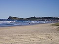
The headland, also known as Lennox Point, is used by surfers, who come for the noted righthand break. [4] Hang-gliders too visit the headland to launch off its 65m cliff. The point is also used for watching dolphins surfing and the annual whale migration. [5] The Pat Morton lookout (at the headland) has views of the village and of Seven Mile Beach extending north towards Broken Head. [5]

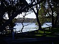
The town is known for its pub, caravan park, as well as Lake Ainsworth, a freshwater lake that has distinctive tannin-stained waters from the surrounding tea trees and is in contrasts with the white sands of Seven Mile Beach. [5] Over the warmer summer months the lake is subject to blue green algal bloom.

Also located in the village is a Bora ring of some significance to the local Bundjalung Tribe. [5]

Lennox Head markets are held on the second and fifth Sunday of the month, at the community centre.

The town also has a small primary school (Lennox Head Public School).

Sport and recreation

Lennox Head Dolphins is a rugby league club that competes in the Northern Rivers Regional Rugby League competition.

Lennox Head Rugby Union Club is a rugby union club that competes in the Far North Coast Rugby zone. Known as The Trojans, it was established in 1999. The club’s home ground is Williams Reserve, Lennox Head.

Notable residents

Related Research Articles

<span class="mw-page-title-main">Bundjalung National Park</span> National park in Australia

The Bundjalung National Park is a 210-square-kilometre (81 sq mi) national park located on the north coast of New South Wales, Australia, 554 kilometres (344 mi) north-east of Sydney. It protects an area of coastal plain, heathland and solitary beaches between the towns of Iluka and Evans Head.

<span class="mw-page-title-main">Burleigh Head National Park</span> Protected area in Queensland, Australia

Burleigh Head is a small national park at Burleigh Heads in the City of Gold Coast in South East Queensland, Australia.

<span class="mw-page-title-main">Kiama, New South Wales</span> Town in New South Wales, Australia

Kiama is a coastal town 120 kilometres south of Sydney in the Illawarra. One of the main tourist attractions is the Kiama Blowhole. Kiama features several popular surfing beaches and caravan parks, and numerous alfresco cafes and restaurants. Its proximity to the south of Sydney makes it an attractive destination for many day-trippers and weekenders.

<span class="mw-page-title-main">Palm Beach, New South Wales</span> Suburb of Sydney, New South Wales, Australia

Palm Beach is a suburb in the Northern Beaches region of Sydney, in the state of New South Wales, Australia. Palm Beach is located 41 kilometres (25 mi) north of the Sydney central business district, in the local government area of Northern Beaches Council. Palm Beach sits on a peninsula at the end of Barrenjoey Road, between Pittwater and Broken Bay. The population of Palm Beach was 1,593 as at the 2016 census.

<span class="mw-page-title-main">Cape Byron</span>

Cape Byron is the easternmost point of the mainland of Australia, located in New South Wales. It is about 3 km (1.9 mi) east of the town of Byron Bay, New South Wales and projects into the Pacific Ocean at 28.6335° S, 153.6383° E. A lighthouse is situated there. It is a popular area for hiking and for whale watching. Two national parks, one a conservation area and a marine park, are on the bay.

<span class="mw-page-title-main">Northern Rivers</span> Region in New South Wales, Australia

Northern Rivers is the most north-easterly region of the Australian state of New South Wales, located between 590 and 820 kilometres north of the state capital, Sydney, and encompasses the catchments and fertile valleys of the Clarence, Richmond, and Tweed rivers. It extends from Tweed Heads in the north to the southern extent of the Clarence river catchment which lies between Grafton and Coffs Harbour, and includes the main towns of Tweed Heads, Byron Bay, Ballina, Kyogle, Lismore, Casino and Grafton. At its most northern point, the region is 102 kilometres (63 mi) south-southeast of the Queensland capital, Brisbane.

<span class="mw-page-title-main">Ballina, New South Wales</span> Town in New South Wales, Australia

Ballina is a town in the Northern Rivers region of New South Wales, Australia, and the seat of the Ballina Shire local government area. Ballina's urban population at June 2018 was 26,381. The town lies on the Richmond River and serves as a gateway to Byron Bay.

<span class="mw-page-title-main">Mount Canobolas</span> Mountain in New South Wales, Australia

Mount Canobolas, a mountain on a spur of the Great Dividing Range, is located in the Central Tablelands region of New South Wales, Australia.

<span class="mw-page-title-main">Tweed Heads, New South Wales</span> Town in New South Wales, Australia

Tweed Heads is a town in New South Wales. It is located on the Tweed River in north-eastern New South Wales, Australia, in Tweed Shire, next to the border with Queensland and adjacent to its "twin town" of Coolangatta, which is a suburb of the Gold Coast. It is often referred to as a town where people can change time zones – even celebrate New Year twice within an hour – simply by crossing the street, due to its proximity to the Queensland border, and the fact that New South Wales observes daylight saving whereas Queensland does not.

<span class="mw-page-title-main">Evans Head, New South Wales</span> Seaside village in New South Wales, Australia

Evans Head is a town in Richmond Valley Council of the Northern Rivers region of New South Wales, Australia. At the 2016 census, Evans Head had a population of 2,843 people. It is 726 kilometres north of Sydney, and 11 kilometres east off the Pacific Highway from Woodburn.

<span class="mw-page-title-main">Electoral district of Ballina</span> State electoral district of New South Wales, Australia

Ballina is an electoral district of the Legislative Assembly in the Australian state of New South Wales.

The Summerland Australian Football League or SAFL was an Australian rules football competition in the Northern Rivers and New England region of New South Wales, Australia, in existence from 1984 to 2011. It now is reformed under the AFL Queensland banner under various QFA divisions, currently QFA Division 2 South/Northern Rivers.

<span class="mw-page-title-main">Bawley Point</span> Place in New South Wales, Australia

Bawley Point is a small coastal hamlet in New South Wales, Australia, in the Shoalhaven with a population of 698 people at the 2016 census. It is located 30 minutes south of Ulladulla, New South Wales, and 30 minutes north of Batemans Bay on the South Coast of NSW. The town's name is believed to be derived from an Aboriginal word meaning "Brown snake".

<span class="mw-page-title-main">Alstonville, New South Wales</span> Town in New South Wales, Australia

Alstonville is a town in northern New South Wales, Australia, part of the region known as the Northern Rivers. Alstonville is on the Bruxner Highway between the town of Ballina and city of Lismore. The village of Wollongbar is 4 km to the west of Alstonville. Alstonville is the service centre of the area known as the Alstonville Plateau.

Group 18 is the name of a junior rugby league competition on the far north coast of New South Wales, Australia. Currently, the group has no senior competition. Prior to 2005, there was a joint Gold Coast-Group 18 competition which fielded teams from both the Queensland and New South Wales sides of the border. With the Burleigh Bears joining the Queensland Cup in 1997 and the Tweed Heads Seagulls joining them in 2003, the combined competition started to lose some of its lustre. In 2005, it was dissolved with the remaining Queensland teams forming a dedicated Gold Coast competition and the NSW teams joining an expanded Group 1 competition, now named Northern Rivers Regional Rugby League. Both Group 1 and Group 18 run junior competitions.

<span class="mw-page-title-main">Ballina Shire</span> Local government area in New South Wales, Australia

Ballina Shire is a local government area in the Northern Rivers region of New South Wales, Australia. The Shire was formed on 1 January 1977 by the amalgamation of the Municipality of Ballina and Tintenbar Shire. The Shire is located adjacent to the Tasman Sea and the Pacific Highway. The council seat is located in the town of Ballina. The population of the Ballina Shire area was 44,208 in June 2018.

The Rainforest Way is a circular series of tourist drives that extends through South East Queensland, Australia across the border into the Northern Rivers region of New South Wales.

<span class="mw-page-title-main">Scotts Head, New South Wales</span> Suburb of Nambucca Valley Council, New South Wales, Australia

Scotts Head is a coastal village of the Nambucca Valley local government area in the Mid North Coast region of New South Wales, Australia. Located on the coast of the Pacific Ocean, approximately 10 kilometres (6 mi) from the Pacific Highway and 480 kilometres (300 mi) from Sydney, it stretches southwards from just south of the mouth of the Nambucca River to the town of Scotts Head in the south.

<span class="mw-page-title-main">Northern Rivers Regional Rugby League</span>

The Northern Rivers Regional Rugby League (NRRRL) is a rugby league competition run in the far north of New South Wales, Australia. It is run under the auspices of the Country Rugby League. The league formed in 2005 as an extended Group 1 Rugby League competition, featuring teams from Group 18 Rugby League. Prior to this, teams from Group 18 played in a competition with teams from the Gold Coast region of Queensland. Both Group 1 and Group 18 continue to run junior competitions.

<span class="mw-page-title-main">Limeburners Creek National Park</span> Protected area in New South Wales, Australia

Limeburners Creek National Park is a protected national park on the Mid North Coast of New South Wales, Australia. The 91.2 km national park is located 5 km (3.1 mi) to the north of Port Macquarie and exists across both the Kempsey Shire and Port Macquarie-Hastings Council local government areas, but is chiefly managed by National Parks and Wildlife Service. The area was originally erected as a nature reserve but this reservation was revoked when it became formally recognised as a national park in 2010 under the National Parks and Wildlife Act (1974). Many threatened ecological habitats and species of fauna and flora are found within this park, alongside several heritage sites of cultural significance, particularly to the local Birpai and Dunghutti people upon whose land the park exists. The protected status of this national park is largely owing to the ecological and cultural value of the area, in addition to the value of the ecosystems to further scientific research.

References

  1. 1 2 3 Australian Bureau of Statistics (27 June 2017). "Lennox Head - Skennars Head (Statistical Area Level 2)". 2016 Census QuickStats. Retrieved 25 November 2017.
  2. Tatnell, Paul (3 June 2010). "Waterspout wrecks homes in NSW town as storm hits hard". Sydney Morning Herald. Retrieved 3 June 2010.
  3. "NSW tornado 'just the beginning'". The Northern Star. 3 June 2010. Retrieved 3 June 2010.
  4. "Lennox Head". Destination NSW. Retrieved 11 November 2013.
  5. 1 2 3 4 "About Lennox Head". Summerland NSW. 2012. Retrieved 29 August 2012.
  6. "Patrick Rafter – Overview". ATP Tour . Retrieved 14 January 2021.
  7. McMillen, Andrew (17 February 2018). "Ball Park Music rises from uni beginnings to stardom". The Australian . Retrieved 22 February 2018.