Big Badja Hill | |
---|---|
Big Badga Mountain | |
summit of Big Badja | |
Highest point | |
Elevation | 1,363 m (4,472 ft) |
Coordinates | 36°00.29304′S149°33.9524′E / 36.00488400°S 149.5658733°E Coordinates: 36°00.29304′S149°33.9524′E / 36.00488400°S 149.5658733°E |
Geography | |
Location in New South Wales | |
Location | Southern Tablelands, New South Wales, Australia |
Parent range | Great Dividing Range |
Big Badja Hill, or Big Badga Mountain, a mountain on the Great Dividing Range, is located in the Southern Tablelands region of New South Wales, Australia, 47 kilometres (29 mi) north-east of Cooma. With an elevation of 1,363 metres (4,472 ft) above sea level, [1] the mountain is situated on the western edge of Deua National Park. [2]
A mountain is a large landform that rises above the surrounding land in a limited area, usually in the form of a peak. A mountain is generally steeper than a hill. Mountains are formed through tectonic forces or volcanism. These forces can locally raise the surface of the earth. Mountains erode slowly through the action of rivers, weather conditions, and glaciers. A few mountains are isolated summits, but most occur in huge mountain ranges.
The Great Dividing Range, or the Eastern Highlands, is Australia's most substantial mountain range and the third longest land-based range in the world. It stretches more than 3,500 kilometres (2,175 mi) from Dauan Island off the northeastern tip of Queensland, running the entire length of the eastern coastline through New South Wales, then into Victoria and turning west, before finally fading into the central plain at the Grampians in western Victoria. The width of the range varies from about 160 km (100 mi) to over 300 km (190 mi). The Greater Blue Mountains Area, Gondwana Rainforests, and Wet Tropics of Queensland World Heritage Areas are located in the range.
The Southern Tablelands is a geographic area of New South Wales, Australia, located south-west of Sydney and west of the Great Dividing Range.
Plants found nearby are the Big Badja Gum and Kunzea badjaensis , a small myrtle with heads of white flowers on the ends of the branches. [3]
Eucalyptus badjensis, commonly known as the Big Badja gum, is a tree that is endemic to south-eastern New South Wales. It has hard, rough bark on the lower part of the trunk, smooth grey bark above, often hanging in strips on the upper branches, linear to narrow lance-shaped, often curved adult leaves, green to yellow buds in groups of three in leaf axils, white flowers and conical or bell-shaped fruit.
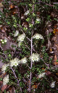
Kunzea badjaensis is a flowering plant in the myrtle family, Myrtaceae and is endemic to a small area of New South Wales. It is a shrub with egg-shaped leaves and clusters of white flowers near the end of the branches. It grows at high altitudes on the Southern Tablelands.
Myrtaceae or the myrtle family is a family of dicotyledonous plants placed within the order Myrtales. Myrtle, pohutukawa, bay rum tree, clove, guava, acca (feijoa), allspice, and eucalyptus are some notable members of this group. All species are woody, contain essential oils, and have flower parts in multiples of four or five. The leaves are evergreen, alternate to mostly opposite, simple, and usually entire. The flowers have a base number of five petals, though in several genera the petals are minute or absent. The stamens are usually very conspicuous, brightly coloured and numerous.
Deua is a national park located in New South Wales, Australia, 320 kilometres (200 mi) south of Sydney, and 100 kilometres (62 mi) east of Canberra. The nearest towns on the coast are Batemans Bay, Moruya and Narooma.
Wadbilliga National Park is a 985.3 km2 (380 sq mi) national park that is located in high country spanning the Monaro and South Coast regions of south-eastern New South Wales, Australia.
The Numeralla River, a perennial river that is part of the Murrumbidgee catchment within the Murray–Darling basin, is located in the Monaro region of New South Wales, Australia.
The Deua River, being the main perennial river of the Moruya River catchment, is located in the South Coast region of New South Wales, Australia.
Dampier County is one of the 141 Cadastral divisions of New South Wales. The Deua River is the northern boundary, with land slightly to the north of the Brogo River the southern boundary. It includes Bermagui, Narooma, Bodalla, and most of the Deua National Park and Wadbilliga National Park.
Kunzea ambigua, commonly known as white kunzea, poverty bush or tick bush, is a plant in the myrtle family, Myrtaceae and is found mainly on sandstone soils in eastern Australia. Growing up to 5 m (16 ft) high and wide, it bears small white flowers in spring. Used in native gardening, it attracts native insects. It is also used in amenities planting and sand dune stabilization.
Eucalyptus triflora is a rare eucalyptus, growing at high altitude in south eastern New South Wales.
The Big Badja River, a perennial river of the Murrumbidgee catchment within the Murray–Darling basin, is located in the Monaro region of New South Wales, Australia.
Buckenbowra River, a perennial river of the Clyde River catchment, is located in the upper ranges of the South Coast region of New South Wales, Australia.
Kunzea 'Badja Carpet' is a cultivar of Kunzea badjaensis. It is a low-growing shrub of the Myrtaceae family found in the southeastern tablelands of New South Wales, Australia. It is similar to Kunzea capitata, but it has a lower growth form and white rather than pink flowers. Because of these differences it has been described as a distinct species. The species had previously been known as Kunzea sp. 'Wadbilliga'.
Eucalyptus wilcoxii, the Deua Gum is mountain eucalyptus of south eastern Australia. Usually a multi-stemmed mallee or small tree reaching 15 metres in height.
Yowrie River, a perennial river of the Tuross River catchment, is located in the upper ranges of the South Coast region of New South Wales, Australia.
Araluen Creek, a partly perennial stream of the Moruya River catchment, is located in the Southern Tablelands and South Coast regions of New South Wales, Australia.
Bettowynd Creek, a partly perennial stream of the Moruya River catchment, is located in the Southern Tablelands and South Coast regions of New South Wales, Australia.
Badja could refer to:
Berlang is a locality in Queanbeyan-Palerang Regional Council, New South Wales, Australia. It was previously called Tallaganda. The town lies about 44km south of Braidwood on the upper Shoalhaven River and the road to Cooma. At the 2016 census, it had a population of none. It includes part of the Deua National Park and the Berlang State Conservation Area. The Big Hole is a notable geological feature in the locality and the Deua National Park.
Deua River Valley is a locality in the Eurobodalla Shire, New South Wales, Australia. It is located about 20 km northwest of Moruya on the road to Araluen in the valley of the Deua River. At the 2016 census, it had a population of 76. Much of its territory lies in the Deua National Park.