Main Range (Snowy Mountains)

Last updated
The Main Range of the Snowy Mountains
Kosciuszko Townsend.jpg
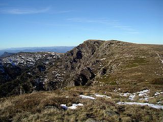
The southern part of the Main Range, looking towards Mount Kosciuszko with the Ramshead Range in the background.
Highest point
PeakMount Kosciuszko
Elevation 2,228 m (7,310 ft)
Coordinates 36°27′S148°16′E / 36.450°S 148.267°E / -36.450; 148.267 Coordinates: 36°27′S148°16′E / 36.450°S 148.267°E / -36.450; 148.267
Geography
CountryAustralia
State/ProvinceNew South Wales

The section of the Great Dividing Range between the Ramshead Range and Dicky Cooper Bogong in the Snowy Mountains is known as the Main Range. It can also be used more generally for the peaks (not necessarily on the Great Dividing Range) on or on short spurs off the range. It contains many of the highest peaks in mainland Australia. Some peaks on the Main Range include (from the south):

Great Dividing Range mountain range in the Australian states of Queensland, New South Wales and Victoria

The Great Dividing Range, or the Eastern Highlands, is Australia's most substantial mountain range and the third longest land-based range in the world. It stretches more than 3,500 kilometres (2,175 mi) from Dauan Island off the northeastern tip of Queensland, running the entire length of the eastern coastline through New South Wales, then into Victoria and turning west, before finally fading into the central plain at the Grampians in western Victoria. The width of the range varies from about 160 km (100 mi) to over 300 km (190 mi). The Greater Blue Mountains Area, Gondwana Rainforests, and Wet Tropics of Queensland World Heritage Areas are located in the range.

Ramshead Range mountain in Australia

The Ramshead Range, a mountain range that is part of the Snowy Mountains, is located in the Monaro region of New South Wales and the Alpine region of Victoria, Australia.

Snowy Mountains region of New South Wales, Australia

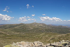
The Snowy Mountains, known informally as "The Snowies", is an IBRA subregion and the highest mountain range on the continent of mainland Australia. It contains the Australian mainland's highest mountain, Mount Kosciuszko, which reaches to a height of 2,228 m (7,310 ft) above sea level. The range also contains the five highest peaks on the Australian mainland, all of which are above 2,100 m (6,890 ft). They are located in southern New South Wales and are part of the larger Australian Alps and Great Dividing Range. Unusual for Australia, the mountain range experiences large natural snowfalls every winter. Snow normally falls during June, July, August and early September, with the snow cover melting by late spring. The Tasmanian highlands makes up the other (major) alpine region present in Australia.

Mount Kosciuszko highest mountain in mainland Australia

Mount Kosciuszko is mainland Australia's highest mountain, at 2,228 metres (7,310 ft) above sea level. It is located on the Main Range of the Snowy Mountains in Kosciuszko National Park, part of the Australian Alps National Parks and Reserves, in New South Wales, Australia, and is located west of Crackenback and close to Jindabyne.

Mount Townsend mountain in New South Wales, Australia

Mount Townsend, a mountain in the Main Range of the Great Dividing Range, is located in the Snowy Mountains region of New South Wales, Australia.

Carruthers Peak mountain in New South Wales, Australia

Carruthers Peak, formerly Curruthers Peak, a mountain in the Main Range of the Great Dividing Range, is located in Snowy Mountains region in southeast New South Wales, Australia. The peak is situated between Mount Lee and Mount Twynam within the Kosciuszko National Park.

Topographic map of the Main Range. Main Range map Stevage.png
Topographic map of the Main Range.

See also

Related Research Articles

Alpine National Park Protected area in Victoria, Australia

The Alpine National Park is a national park located in the Central Highlands and Alpine regions of Victoria, Australia. The 646,000-hectare (1,600,000-acre) national park is located northeast of Melbourne. It is the largest National Park in Victoria, and covers much of the higher areas of the Great Dividing Range in Victoria, including Victoria's highest point, Mount Bogong at 1,986 metres (6,516 ft) and the associated subalpine woodland and grassland of the Bogong High Plains. The park's north-eastern boundary is along the border with New South Wales, where it abuts the Kosciuszko National Park. On 7 November 2008 the Alpine National Park was added to the Australian National Heritage List as one of eleven areas constituting the Australian Alps National Parks and Reserves.

Kosciuszko National Park Protected area in New South Wales, Australia

The Kosciuszko National Park is a 6,900-square-kilometre (2,700 sq mi) national park and contains mainland Australia's highest peak, Mount Kosciuszko, for which it is named, and Cabramurra the highest town in Australia. Its borders contain a mix of rugged mountains and wilderness, characterised by an alpine climate, which makes it popular with recreational skiers and bushwalkers.

Australian Alps Region in Australia

The Australian Alps, an interim Australian bioregion, is the highest mountain range in Australia. This range is located in southeastern Australia, and it straddles eastern Victoria, southeastern New South Wales, and the Australian Capital Territory. The Australian Alps contain Australia's only peaks exceeding 2,000 metres (6,600 ft) in elevation above sea level. The Alps are the only bioregion on the Australian mainland in which deep snow falls annually. The Alps comprise an area of 1,232,981 hectares.

Mount Bogong mountain

Mount Bogong,, located in the Alpine National Park and part of the Victorian Alps of the Great Dividing Range, is the highest mountain in Victoria, Australia, at 1,986 metres (6,516 ft) above sea level.

Victorian Alps mountains in Australia

The Victorian Alps, an extensive mountain range that forms the southern part of the Australian Alps located in the Australian state of Victoria, is part of the Great Dividing Range, an Interim Biogeographic Regionalisation for Australia (IBRA) sub-bioregion of approximately 519,866 hectares, and an administrative sub-region bordering the Gippsland and Hume regions.

Mount Jagungal mountain in Australia

Mount Jagungal or sometimes Jagungal, Big Bogong, The Big Bogong Nr., or The Big Bogong Mountain, is a mountain within the Jagungal Wilderness Area of the Kosciuszko National Park in the Snowy Mountains region of New South Wales, Australia.

Mount Twynam mountain in New South Wales, Australia

Mount Twynam is a mountain located on the Main Range, part of the Great Dividing Range, in the Snowy Mountains in New South Wales, Australia. The mountain is located close the border between New South Wales and Victoria.

Mount Tate (New South Wales) mountain in New South Wales, Australia

Mount Tate is a prominent rocky mountain on the Main Range of the Snowy Mountains located in southeastern New South Wales, Australia.

The Horn (Mount Buffalo) mountain in Australia

The Horn is the most prominent peak on the Mount Buffalo plateau in Victoria, Australia. The Horn has an elevation of 1,723 metres (5,653 ft) AHD.

Geography of Victoria

Victoria is the southernmost mainland state of Australia. With an area of 227,594 km², it is Australia's sixth largest state or territory. The State is comparable in size to the US state of Utah or the island of Great Britain. It is bound to the northwest by South Australia, directly north by New South Wales, and also shares a maritime border with Tasmania to the south, across the Bass Strait. Most of Victoria's northern border lies along the Murray River. The eastern half of the state is dominated by the Great Dividing Range and the surrounding uplands, which also to a lesser extent extend far into the west of the state and ease off after The Grampians. By comparison the north and northwest of the state is extremely flat with little prominence. Approximately three quarters of Victoria's population lives on and around the coast of the Port Phillip and Western Port bays, chiefly in Melbourne, in Victoria's South Central region.

Peak River river in New South Wales, Australia

The Peak River, a perennial stream that is part of the Murrumbidgee catchment within the Murray–Darling basin, is located in the Snowy Mountains region of New South Wales, Australia.

Skiing in Australia overview of skiing practiced in Australia

Skiing in Australia takes place in the high country of the states of New South Wales, Victoria and Tasmania, as well as in the Australian Capital Territory, during the southern hemisphere winter.

Rams Head mountain in New South Wales, Australia

The Rams Head is a mountain located in the Ramshead Range of the Snowy Mountains in New South Wales, Australia.

Perisher Ski Resort ski resort in New South Wales, Australia

Perisher Ski Resort is the largest ski resort in the Southern Hemisphere. Located in the Australian Snowy Mountains, the resort is an amalgamation of four villages and their associated ski fields, covering approximately 12 square kilometres (5 sq mi), with the base elevation at 1,720 metres (5,640 ft) AHD, and the summit elevation of 2,054 metres (6,739 ft) at the top of Mount Perisher. 4.4 square kilometres (1.7 sq mi) of this area is covered by 240 snow guns, which are used to artificially supplement the natural snowfall. Perisher was acquired by Vail Resorts, United States on March 30, 2015 for a sum of approximately AU$177 million.

This is a list of mountain ranges, including ranges of hills, that occur in Australia.

References

International Standard Book Number Unique numeric book identifier

The International Standard Book Number (ISBN) is a numeric commercial book identifier which is intended to be unique. Publishers purchase ISBNs from an affiliate of the International ISBN Agency.