Mount Tate (New South Wales)

Last updated

Mount Tate
Guthega Tate.JPG
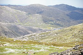
The view southeast from Mount Tate
Highest point
Elevation 2,068 m (6,785 ft) [1] [2] [3]
Prominence 188 m (617 ft) [1]
Isolation 5.59 km (3.47 mi) [1]
Coordinates 36°21′S148°21′E / 36.350°S 148.350°E / -36.350; 148.350 Coordinates: 36°21′S148°21′E / 36.350°S 148.350°E / -36.350; 148.350 [4]
Geography
Australia New South Wales relief location map.png
Red triangle with thick white border.svg
Mount Tate
Location in New South Wales
Location Snowy Mountains, New South Wales, Australia
Parent range Main Range, Great Dividing Range
Climbing
Easiest route Walk (hike)

Mount Tate is a prominent rocky mountain on the Main Range of the Snowy Mountains located in southeastern New South Wales, Australia.

Mountain A large landform that rises fairly steeply above the surrounding land over a limited area

A mountain is a large landform that rises above the surrounding land in a limited area, usually in the form of a peak. A mountain is generally steeper than a hill. Mountains are formed through tectonic forces or volcanism. These forces can locally raise the surface of the earth. Mountains erode slowly through the action of rivers, weather conditions, and glaciers. A few mountains are isolated summits, but most occur in huge mountain ranges.

Main Range (Snowy Mountains) mountains in Australia

The section of the Great Dividing Range between the Ramshead Range and Dicky Cooper Bogong in the Snowy Mountains is known as the Main Range. It can also be used more generally for the peaks on or on short spurs off the range. It contains many of the highest peaks in mainland Australia. Some peaks on the Main Range include :

Snowy Mountains region of New South Wales, Australia

The Snowy Mountains, known informally as "The Snowies", is an IBRA subregion and the highest mountain range on the continent of mainland Australia. It contains the Australian mainland's highest mountain, Mount Kosciuszko, which reaches to a height of 2,228 m (7,310 ft) above sea level. The range also contains the five highest peaks on the Australian mainland, all of which are above 2,100 m (6,890 ft). They are located in southern New South Wales and are part of the larger Australian Alps and Great Dividing Range. Unusual for Australia, the mountain range experiences large natural snowfalls every winter. Snow normally falls during June, July, August and early September, with the snow cover melting by late spring. The Tasmanian highlands makes up the other (major) alpine region present in Australia.

With an elevation of 2,068 metres (6,785 ft) above sea level, [1] Mount Tate has two ridges running north and south, named Tate West Ridge and Tate East Ridge, referring to the side of the Great Divide where they lie. It has views along the Main Range towards Mount Twynam and down to the Geehi Valley. [5]

The Australian Height Datum is a vertical datum in Australia. According to Geoscience Australia, "In 1971 the mean sea level for 1966-1968 was assigned the value of 0.000m on the Australian Height Datum at thirty tide gauges around the coast of the Australian continent. The resulting datum surface, with minor modifications in two metropolitan areas, has been termed the Australian Height Datum (AHD) and was adopted by the National Mapping Council as the datum to which all vertical control for mapping is to be referred."

Great Dividing Range mountain range in the Australian states of Queensland, New South Wales and Victoria

The Great Dividing Range, or the Eastern Highlands, is Australia's most substantial mountain range and the third longest land-based range in the world. It stretches more than 3,500 kilometres (2,175 mi) from Dauan Island off the northeastern tip of Queensland, running the entire length of the eastern coastline through New South Wales, then into Victoria and turning west, before finally fading into the central plain at the Grampians in western Victoria. The width of the range varies from about 160 km (100 mi) to over 300 km (190 mi). The Greater Blue Mountains Area, Gondwana Rainforests, and Wet Tropics of Queensland World Heritage Areas are located in the range.

Mount Twynam mountain in New South Wales, Australia

Mount Twynam is a mountain located on the Main Range, part of the Great Dividing Range, in the Snowy Mountains in New South Wales, Australia. The mountain is located close the border between New South Wales and Victoria.

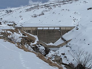
The mountain is situated approximately 3 kilometres (1.9 mi) northeast of Guthega and southwest of Guthega Power Station. [3]

Guthega, New South Wales Town in New South Wales, Australia

Guthega is a ski village and the site for a hydro electric dam located in the Kosciuszko National Park, on the upper reaches of the Snowy River, on the western face of Mount Blue Cow, Snowy Mountains of New South Wales, Australia.

Guthega Power Station

Guthega Power Station is located in the Snowy Mountains region of New South Wales, Australia. The power station's purpose is for the generation of electricity. It is the first to be completed and smallest of the initial seven hydroelectric power stations that comprise the Snowy Mountains Scheme, a vast hydroelectricity and irrigation complex constructed in south-east Australia between 1949 and 1974 and now run by Snowy Hydro.

See also

Australian Alps Region in Australia

The Australian Alps, an interim Australian bioregion, is the highest mountain range in Australia. This range is located in southeastern Australia, and it straddles eastern Victoria, southeastern New South Wales, and the Australian Capital Territory. The Australian Alps contain Australia's only peaks exceeding 2,000 metres (6,600 ft) in elevation above sea level. The Alps are the only bioregion on the Australian mainland in which deep snow falls annually. The Alps comprise an area of 1,232,981 hectares.

Related Research Articles

Alpine Way highway in New South Wales

The Alpine Way is a 121-kilometre (75 mi) rural road located in the Snowy Mountains region of New South Wales, Australia. The road connects Jindabyne in the east to the New South Wales/Victorian border in the west, crossing the Murray River, near Upper Towong. The route does not carry an official shield designation.

Perisher Valley, New South Wales human settlement in New South Wales, Australia

Perisher Valley, commonly called Perisher, is a valley formed below Mount Perisher, a mountain that is located in the Snowy Mountains of New South Wales, Australia.

Blue Cow Mountain ski resort

Blue Cow is a ski resort that is part of Perisher located in the Snowy Mountains of New South Wales, Australia, within the Snowy Monaro Regional Council. The resort is situated within the Kosciuszko National Park and is administered by the NSW National Parks & Wildlife Service. During winter months, the only access to the village is via the Skitube underground railway. In summer, access is via off-road only. Blue Cow is one of the four resort bases within Perisher, Australia's largest ski resort.

Mount Townsend mountain in New South Wales, Australia

Mount Townsend, a mountain in the Main Range of the Great Dividing Range, is located in the Snowy Mountains region of New South Wales, Australia.

Mount Jagungal mountain in Australia

Mount Jagungal or sometimes Jagungal, Big Bogong, The Big Bogong Nr., or The Big Bogong Mountain, is a mountain within the Jagungal Wilderness Area of the Kosciuszko National Park in the Snowy Mountains region of New South Wales, Australia.

Smiggin Holes, New South Wales Town in New South Wales, Australia

Smiggin Holes is a village in the ski resort area of Snowy Mountains of New South Wales, Australia, in the Snowy Monaro Regional Council. It is primarily a winter-only resort village. It is within the Kosciuszko National Park, and is administered by New South Wales Department of Environment and Climate Change. Access to the village is via road. There is an access fee payable to the national park, and motor vehicles are not permitted to stay overnight in the winter months.

Round Mountain (Snowy Mountains) mountain in Australia

The Round Mountain, one of three peaks of the same name in the region, is a mountain located on the Main Range of the Snowy Mountains, part of the Great Dividing Range, in southeastern New South Wales, Australia.

Carruthers Peak mountain in New South Wales, Australia

Carruthers Peak, formerly Curruthers Peak, a mountain in the Main Range of the Great Dividing Range, is located in Snowy Mountains region in southeast New South Wales, Australia. The peak is situated between Mount Lee and Mount Twynam within the Kosciuszko National Park.

The Geehi River, a perennial river of the Murray catchment of the Murray-Darling basin, is located in the Snowy Mountains region of New South Wales, Australia.

The Jacobs River, a perennial river of the Snowy River catchment, is located in the Snowy Mountains region of New South Wales, Australia.

Swampy Plain River, a perennial stream that is part of the Murray catchment within the Murray–Darling basin, is located in the Snowy Mountains bioregion of New South Wales, Australia.

Gungartan mountain in Australia

Gungartan is a mountain located in the Snowy Mountains region of New South Wales, Australia.

Perisher Ski Resort ski resort in New South Wales, Australia

Perisher Ski Resort is the largest ski resort in the Southern Hemisphere. Located in the Australian Snowy Mountains, the resort is an amalgamation of four villages and their associated ski fields, covering approximately 12 square kilometres (5 sq mi), with the base elevation at 1,720 metres (5,640 ft) AHD, and the summit elevation of 2,054 metres (6,739 ft) at the top of Mount Perisher. 4.4 square kilometres (1.7 sq mi) of this area is covered by 240 snow guns, which are used to artificially supplement the natural snowfall. Perisher was acquired by Vail Resorts, United States on March 30, 2015 for a sum of approximately AU$177 million.

Geehi Dam

Geehi Dam is a major ungated rockfill embankment dam with an uncontrolled morning glory spillway spillway across the Geehi River in the Snowy Mountains of New South Wales, Australia. The dam's main purpose is for the generation of hydro-power and is one of the sixteen major dams that comprise the Snowy Mountains Scheme, a vast hydroelectricity and irrigation complex constructed in south-east Australia between 1949 and 1974 and now run by Snowy Hydro.

Guthega Dam

Guthega Dam is concrete gravity dam with an uncontrolled spillway across the Snowy River in the Snowy Mountains of New South Wales, Australia. The dam's main purpose is for the storage of water used in the generation of hydro-power. It is the first to be completed of the sixteen major dams of the Snowy Mountains Scheme, a vast hydroelectricity and irrigation complex constructed in south-east Australia between 1949 and 1974 and now run by Snowy Hydro.

References

  1. 1 2 3 4 "Mount Tate, Australia". Peakbagger.com. Retrieved 28 May 2015.
  2. "Mount Tate - NSW". ExplorOz. I.T. Beyond Pty Ltd. 2015. Retrieved 27 May 2015.
  3. 1 2 "Map of Mount Tate, NSW". Bonzle Digital Atlas of Australia. Retrieved 27 May 2015.
  4. "Mount Tate". Geographical Names Register (GNR) of NSW. Geographical Names Board of New South Wales . Retrieved 27 May 2015. OOjs UI icon edit-ltr-progressive.svg
  5. Geehi Bushwalking Club, (2001) 8th ed. Snowy Mountains Walks, Canberra: National Capital Printing. ISBN   0-9599651-4-9