
Great Western Highway is a 202-kilometre-long (126 mi) state highway in New South Wales, Australia. From east to west, the highway links Sydney with Bathurst, on the state's Central Tablelands.

Lithgow is a town in the Central Tablelands of New South Wales, Australia and is the administrative center of the City of Lithgow local government area. It is located in a mountain valley named Lithgow's Valley by John Oxley in honour of William Lithgow, the first Auditor-General of New South Wales.
William Cox was an English soldier, known as an explorer, road builder and pioneer in the early period of British settlement of Australia.

Linden is a village in the Blue Mountains of New South Wales, Australia. It is in the City of Blue Mountains, 82 km west of Sydney and 23 km east of Katoomba. The village is on the Great Western Highway and has a railway station on the Main Western railway line served by NSW TrainLink's Blue Mountains Line. It shares a post office, and therefore the 2778 postcode, with adjoining Woodford. In the 2011 census, its population was 594, including 19 indigenous people (3.2%).

The City of Blue Mountains is a local government area of New South Wales, Australia, governed by the Blue Mountains City Council. The city is located in the Blue Mountains, on the Great Dividing Range at the western edge of the Greater Sydney Region in New South Wales, Australia.

Mount Victoria is a small township in the Blue Mountains of New South Wales, Australia. Mount Victoria is geographically the western most village and suburb of Greater Sydney on the great western highway in the City of Blue Mountains, located about 120 kilometres (75 mi) west-northwest by road from the Sydney central business district and at an altitude of about 1,052 metres (3,451 ft) AHD . The settlement had a population of 823 people at the 2011 Census.

Hartley is a historical village in the Central Tablelands region of New South Wales, Australia, within the City of Lithgow local government area, located approximately 127 kilometres (79 mi) west of the Sydney central business district. Hartley is located below the western escarpment of the Blue Mountains.

The City of Lithgow is a local government area in the Central West region of New South Wales, Australia. The area is located adjacent to the Great Western Highway and the Main Western railway line.

Woodford is a village in the Blue Mountains in New South Wales, Australia, about 90 kilometres west of Sydney. Its elevation is 609 metres (1,998 ft) above sea level. It is situated on the Great Western Highway and has a railway station on the Main Western railway line served by NSW TrainLink's Blue Mountains services. At the 2016 census, Woodford had a population of 1,934.
Rydal is a small rural village in New South Wales, Australia.

The Lithgow Zig Zag is a heritage-listed former zig zag railway line built near Lithgow on the Great Western Line of New South Wales in Australia. The zig zag line operated between 1869 and 1910, to overcome an otherwise insurmountable climb and descent on the western side of the Blue Mountains. It was designed by John Whitton and built from 1863 to 1869 by Patrick Higgins as contractor. It is also known as the Great Zig Zag Railway and Reserves and Zig Zag Railway. The property is owned by Department of Planning and Infrastructure. It was added to the New South Wales State Heritage Register on 2 April 1999.
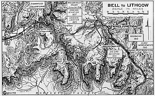
The Ten Tunnels Deviation is a heritage-listed 9.2-kilometre (5.7 mi) section of the Main Western Line between Newnes Junction and Zig Zag stations in Lithgow, New South Wales, Australia. It was designed and built by the New South Wales Government Railways and built from 1 June 1908 and 16 October 1910. It is also known as Great Zig Zag Railway deviation tunnels and Bell to Zig Zag Ten Tunnel Railway Deviation. It was added to the New South Wales State Heritage Register on 2 April 1999.

Hartley Vale is a small village in the Blue Mountains area of New South Wales, Australia. It is approximately 150 kilometres west of Sydney and 12 kilometres south-east of Lithgow. It is in the local government area of the City of Lithgow.

Wallerawang is a small township in the Central Tablelands of New South Wales, Australia. It is located approximately 14 kilometres (8.7 mi) northwest of Lithgow adjacent to the Great Western Highway. It is also located on the Main Western railway line at the junction of the Gwabegar line.

The Cox's Road and Early Deviations - Woodford, Appian Way Precinct is a heritage-listed former colonial road and now access road off The Appian Way, near Woodford, in the City of Blue Mountains local government area of New South Wales, Australia. It was designed and built by William Cox between 1814 and 1825, with the assistance of a convict road party. It is also known as Bathurst Road; Old Bathurst Road and Coxs Road. It was added to the New South Wales State Heritage Register on 25 March 2015.

Cox's Road and Early Deviations - Linden, Linden Precinct is a heritage-listed former road and now fire trail and road at off Railway Parade, Linden, City of Blue Mountains, New South Wales, Australia. It was designed and built by William Cox from 1814, with the assistance of a convict road party.. It is also known as Old Bathurst Road and Coxs Road. It was added to the New South Wales State Heritage Register on 31 July 2015.

Cox's Road and Early Deviations - Woodford, Old Bathurst Road Precinct is a heritage-listed former colonial road and now fire trail and road located at Old Bathurst Road, Woodford in the City of Blue Mountains local government area of New South Wales, Australia. It was designed and built by William Cox from 1814, with the support of a convict road party. It is also known as 1814 Road, Old Bathurst Road, Old Western Road and Coxs Road. It was added to the New South Wales State Heritage Register on 31 July 2015.

Cox's Road and Early Deviations - Sodwalls, Fish River Descent Precinct is a heritage-listed former colonial road and now road and access road at off Cuthill Road, Sodwalls in the City of Lithgow local government area of New South Wales, Australia. It was designed and built by William Cox from 1814 to 1815 with the support of a convict road party. It is also known as Coxs Road and Old Bathurst Road. It was added to the New South Wales State Heritage Register on 25 March 2015.

The Cox's Road and Early Deviations - Hartley, Clarence Hilly Range and Mount Blaxland Precinct is a heritage-listed road at The Old Bathurst Road, Hartley in the City of Lithgow local government area of New South Wales, Australia. It was designed and built by William Cox from 1814 to 1826 with the support of a convict road party. It is also known as Cox's Road and Early Deviations - Hartley, Clarence Hilly Range / Mount Blaxland Precinct and Coxs Road. It was added to the New South Wales State Heritage Register on 25 March 2015.

The Rydal rail underbridges are a series of heritage-listed railway underbridges and viaducts that carry the Main Western line over Solitary Creek at Rydal, in the City of Lithgow local government area of New South Wales, Australia. The property is owned by Transport Asset Holding Entity, an agency of the Government of New South Wales. It was added to the New South Wales State Heritage Register on 2 April 1999.
