
The Great Dividing Range, or the Eastern Highlands, is Australia's most substantial mountain range and the fifth longest land-based range in the world. It runs roughly parallel to the East Coast of Australia and stretches more than 3,500 kilometres (2,175 mi) from Dauan Island in the Torres Strait off the northern tip of Cape York Peninsula, Queensland, running the entire length of the eastern coastline through New South Wales, then into Victoria and turning west, before finally fading into the central plain at the Grampians in western Victoria.

Ku-ring-gai Chase National Park is a national park on the northern side of Sydney in New South Wales, Australia. The 14,977-hectare (37,010-acre) park is 25 kilometres (16 mi) north of the Sydney Central Business District and generally comprises the land east of the M1 Pacific Motorway, south of the Hawkesbury River, west of Pittwater and north of Mona Vale Road. It includes Barrenjoey Headland on the eastern side of Pittwater.

New England or New England North West is the name given to a generally undefined region in the north of the state of New South Wales, Australia, about 60 kilometres (37 miles) inland, that includes the Northern Tablelands and the North West Slopes regions. The population of the region is 202,160 (2006), with over a quarter of the population being from Tamworth Regional Council.

Gwydir River, a major inland perennial river of the Barwon catchment within the Murray-Darling basin, is located in the Northern Tablelands, North West Slopes, and Orana districts of New South Wales, Australia.

Uralla is a town on the Northern Tablelands, New South Wales, Australia. The town is located at the intersection of the New England Highway and Thunderbolts Way, 465 kilometres (289 mi) north of Sydney and about 23 kilometres (14 mi) south west of the city of Armidale. At the 2016 census, the township of Uralla had a population of 2,388 people,.
The Severn River, a perennial river that forms part of the Border Rivers group, is part of the Macintyre catchment of the Murray-Darling basin, located in the Northern Tablelands and North West Slopes regions of New South Wales, Australia.

Thunderbolts Way is a 290-kilometre (180 mi) country road located in the Northern Tablelands region of New South Wales, Australia. The road links Gloucester to Walcha, Uralla, where it very briefly joins the New England Highway and, to Copes Creek, 16 km (10 mi) south of the Gwydir Highway intersection at Inverell. The road is fully sealed and passes through thickly forested mountain areas with many nearby national parks and nature reserves.

The Northern Tablelands, also known as the New England Tableland, is a plateau and a region of the Great Dividing Range in northern New South Wales, Australia. It includes the New England Range, the narrow highlands area of the New England region, stretching from the Moonbi Range in the south to the Queensland border in the north. The region corresponds generally to the Bureau of Meteorology forecast area for the Northern Tablelands which in this case includes Inverell although it is significantly lower in elevation.

Burra is an Australian locality of rural smallholdings lying 20 kilometres to the south of Queanbeyan, New South Wales in the Queanbeyan-Palerang Region. At the 2016 census, Burra had a population of 794 people.

Bundarra is a small town on the Northern Tablelands of New South Wales, Australia. The town is located on Thunderbolts Way and on the banks of the Gwydir River, in the Uralla Shire local government area, 563 kilometres (350 mi) from the state capital, Sydney. At the 2016 census, Bundarra had a population of 394 and the surrounding area had 676 persons.

The Ulandra Nature Reserve is a protected nature reserve that is located in the west hills of the Southern Tablelands and eastern Riverina regions of New South Wales in eastern Australia. The 3,930-hectare (9,700-acre) reserve is situated approximately 25 kilometres (16 mi) south-west of Cootamundra and 4 kilometres (2.5 mi) south-east of the village of Bethungra.
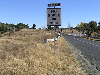
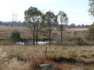
Rocky River is a locality in northern New South Wales, Australia near the town of Uralla on the Northern Tablelands plateau.

The Mount Yarrowyck Nature Reserve is a protected nature reserve that is located on the Northern Tablelands in the New England region of New South Wales, in eastern Australia. The 585-hectare (1,450-acre) reserve is situated near Yarrowyck and 30 kilometres (19 mi) west of Armidale.

Kentucky is a village in the New England region of New South Wales, Australia. It is about 17 kilometres (11 mi) south of Uralla and 35 kilometres (22 mi) north-west of Walcha and about 7 kilometres (4 mi) off the New England Highway. Kentucky is located 540 kilometres (336 mi) by rail from Sydney in Sandon County on the Northern Tablelands. It is at an altitude of 1066m and is within Uralla Shire. At the 2016 census, Kentucky had a population of 158.

Black Mountain is a village situated between Armidale and Guyra, located on the Northern Tablelands in the New England region of New South Wales, Australia. Situated within Armidale Regional Council, as at the 2016 census, Black Mountain had a population of 310.
The Kings Tableland is a plateau, located in the Blue Mountains in Wollondilly Shire, New South Wales, Australia. The ridge is an eroded remnant of a sandstone layer that is approximately 1,000 metres (3,300 ft) AMSL, situated immediately south of Wentworth Falls. The Tableland is the major southerly spur of the main spine of the Blue Mountains Range and forms the beginning of the Southern Escarpment, an unbroken series of tall sandstone cliffs which fringes the Jamison, Megalong, Kanimbla and Hartley Valleys.
Rocky River, a watercourse of the Gwydir catchment within the Murray–Darling basin, is located in the Northern Tablelands district of New South Wales, Australia.
Mount Yarrowyck is a mountain in northern New South Wales, Australia and has an elevation of 1153 metres. The mountain is located 23.4 km west of Uralla, 27.8 km west of Armidale and 38 km west of Guyra. The nearest sealed road to Mount Yarrowyck is located 18 km away named as the Bundarra Road.
The Little Llangothlin Nature Reserve is a protected wetland nature reserve that is located on the Northern Tablelands in the New England region of New South Wales, in eastern Australia. The 257-hectare (640-acre) reserve is situated approximately 10 kilometres (6.2 mi) north-east of the rural locality of Llangothlin, and some 20 kilometres (12 mi) north-east of Guyra.
The Chandlers Creek, a perennial stream that is part of the Clarence River catchment, is located in the Northern Tablelands region of New South Wales, Australia.

