Tenterfield is a regional town in New South Wales, Australia, situated at the junction of the New England and Bruxner highways, along the Northern Tablelands, within the New England region. At the 2016 census, Tenterfield had a population of 4,066. Tenterfield's proximity to many regional centres and its position on the route between Sydney and Brisbane led to its development as a centre for the promotion of the federation of Australia.

The Main North Line is a major railway in New South Wales, Australia. It runs through the Central Coast, Hunter and New England regions. The line was the original main line between Sydney and Brisbane, however this required a change of gauge at Wallangarra. As of 1988, the line closed progressively north of Armidale with services gradually withdrawn till 2004, with the main route between Sydney and Brisbane now the North Coast line.

The Grafton Bridge is a heritage-listed bascule truss bridge that carries the Bent Street and North Coast railway line across the Clarence River in Grafton, New South Wales, Australia. The bridge links the Grafton central business district with South Grafton, and was added to the New South Wales State Heritage Register on 2 April 1999.

Tenterfield Shire is a local government area located in the New England region of New South Wales, Australia. The Shire is situated adjacent to the New England Highway.

Jennings is a town on the Northern Tablelands region of New South Wales, Australia. The town is located in the Tenterfield Shire local government area, 718 kilometres (446 mi) from the state capital, Sydney and 256 kilometres (159 mi) from Brisbane. It is separated by the state border from its neighbouring town of Wallangarra in Queensland. At the 2011 census, Jennings had a population of 211. The New England Highway and the Main North railway line cross the state border at Jennings. The town was named for Sir Patrick Jennings, the first Roman Catholic Premier of New South Wales.

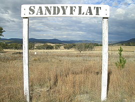
Bolivia is a locality on the Northern Tablelands in the New England region of New South Wales, Australia. The remains of the settlement comprises the former Bolivia Hotel, a disused post office, a disused railway siding and a community hall.
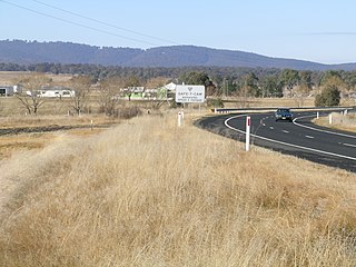
Dundee is a rural locality about 40 kilometres north of Glen Innes on the Northern Tablelands, New South Wales, Australia. It is situated on the New England Highway at the Severn River in Severn parish, Gough County, New South Wales. The elevation is 985 metres.

This list documents historical bridges located in New South Wales, Australia. Road, rail and pedestrian bridges are listed. Generally bridges built before World War II (1939) have been included in this list.

The Tenterfield railway station is a heritage-listed closed railway station and now railway museum located on the Main Northern line, Tenterfield, Tenterfield Shire, New South Wales, Australia. It served the town of Tenterfield and opened on 1 September 1886 when the line was extended from Glen Innes. It was the terminus of the line until it was extended to Wallangarra on 16 January 1888. The railway station was designed by William Murray under the direction of John Whitton, the Chief Engineer of NSW Government Railways, and built during 1886. It is also known as Tenterfield Railway Station group. The property was added to the New South Wales State Heritage Register on 2 April 1999. The station has one platform with two loops.

The Dubbo rail bridge over Macquarie River – Wambuul is a heritage-listed railway bridge on the Main Western line across the Macquarie River, located west of the Dubbo central business district in New South Wales, Australia. It was designed by John Whitton as the Engineer-in-Chief for the New South Wales Government Railways. The bridge was built during 1884 by Benjamin Barnes, with ironwork by Cochrane & Co, Middlesborough, England. The railway bridge is also known as the Dubbo Lattice Railway Bridge. The property is owned by Transport Asset Holding Entity, an agency of the Government of New South Wales. The bridge was added to the New South Wales State Heritage Register on 2 April 1999 and was listed on the Register of the National Estate on 18 April 1989.

The Ingalara Creek railway bridge is a heritage-listed former railway bridge that carried the Bombala railway line across Ingalara Creek at Michelago in the Snowy Monaro Regional Council local government area of New South Wales, Australia. It was designed by John Whitton in his capacity as Engineer-in-Chief for Railways and built in 1889. It is also known as the Michelago Rail Bridge over Ingalara Creek and the Ingalara Creek Railway Viaduct. The property is owned by Transport Asset Holding Entity, an agency of the Government of New South Wales. It was added to the New South Wales State Heritage Register on 2 April 1999. On 1 December 2020, changes were made to exemptions relating to the bridge's heritage status.

The Bredbo River railway bridge is a heritage-listed former railway bridge carrying the Bombala railway line over the Bredbo River at Bredbo in the Snowy Monaro Regional Council local government area of New South Wales, Australia. It was designed by John Whitton in his capacity as Engineer-in-Chief for Railways and built from 1881 to 1889. It is also known as the Bredbo Rail Bridge and the Bredbo River Railway Viaduct. The property is owned by Transport Asset Holding Entity, an agency of the Government of New South Wales. It was added to the New South Wales State Heritage Register on 2 April 1999. On 1 December 2020, changes were made to exemptions relating to the bridge's heritage status.

The Lachlan River railway bridge is a heritage-listed former railway bridge which carried the Blayney–Demondrille railway line over the Lachlan River at Cowra, Cowra Shire, New South Wales, Australia. It was designed by John Whitton in his capacity as Engineer-in-Chief for Railways. The bridge was built from 1886 to 1887 by contractors Fishburn & Co. It is also known as the Cowra Rail Bridge over Lachlan River and the Cowra Lattice Railway Bridge. The property is owned by Transport Asset Holding Entity, an agency of the Government of New South Wales. It was added to the New South Wales State Heritage Register on 2 April 1999.
The Tenterfield Creek railway bridge is a heritage-listed former railway bridge that carried the Main North Line across the Tenterfield Creek from Sunnyside to Jennings, both in the Tenterfield Shire local government area of New South Wales, Australia. It was designed by John Whitton and Engineer-in-Chief for NSW Government Railways and built in 1888. The bridge is also known as the Sunnyside rail bridge over Tenterfield Creek. The property is owned by Transport Asset Holding Entity, an agency of the Government of New South Wales and was added to the New South Wales State Heritage Register on 2 April 1999.

The Murrumbidgee River railway bridge is a heritage-listed railway bridge across the Murrumbidgee River located on the Tumut railway line at Gundagai in the Cootamundra-Gundagai Regional Council local government area of New South Wales, Australia. It was built in 1903. It is also known as the Gundagai Rail Bridge over Murrumbidgee River and the Murrumbidgee River Railway Bridge. The property was added to the New South Wales State Heritage Register on 2 April 1999.
The Manilla railway underbridges are two heritage-listed railway bridges located on the Tamworth-Barraba railway line in the town of Manilla in the Tamworth Regional Council local government area of New South Wales, Australia. The underbridges are owned by Transport Asset Holding Entity, an agency of the Government of New South Wales. The two sites were added to the New South Wales State Heritage Register on 2 April 1999.
The Peel River railway bridge is a heritage-listed railway bridge that carries the Main North line across the Peel River connecting North Tamworth to Tambinda, both in the Tamworth Regional Council local government area of New South Wales, Australia. The railway bridge was designed by John Whitton as the Engineer-in-Chief for Railways and built during 1882 by J. S. Bennett, with iron work by J. & C. Brettell, Worcester, England. The bridge is also known as the Tamworth rail bridge over Peel River and the Tamworth Lattice Railway Bridge. The property is owned by Transport Asset Holding Entity, an agency of the Government of New South Wales. The bridge was added to the New South Wales State Heritage Register on 2 April 1999 and was added to the Register of the National Estate on 18 April 1989.

Murrumbidgee River railway bridge is a heritage-listed disused railway bridge on the Tocumwal railway line crossing from Narrandera to Gillenbah, both in Narrandera Shire, New South Wales, Australia. It was designed by John Whitton in his capacity as Engineer-in-Chief for Railways, and built in 1884–85 by Halliday & Owen with ironwork supplied by English firm Westwood, Baillie. It is also known as Narrandera Lattice Railway Bridge. The property was added to the New South Wales State Heritage Register on 2 April 1999 and was added to the Register of the National Estate on 15 May 1990.

The Yarraford Rail Bridge is a heritage-listed closed railway bridge that carried the Main Northern Line across Beardy Waters, situated 694.371 kilometres (431.462 mi) from Central station, near Glen Innes, in the Glen Innes Severn local government area of New South Wales, Australia. The bridge was designed by John Whitton in his capacity as Engineer-in-Chief for Railways and built in 1886. It is also known as Beardy River Railway Viaduct. The property is owned by Transport Asset Holding Entity, an agency of the Government of New South Wales. It was added to the New South Wales State Heritage Register on 2 April 1999.

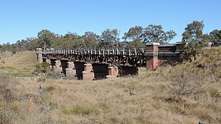
The Severn River railway bridge is a heritage-listed railway bridge that carries the Main Northern Line across the Severn River at Dundee, Glen Innes Severn, New South Wales, Australia. It was designed by John Whitton in his capacity as Engineer-in-Chief for Railways and built in 1886. It is also known as Severn River Railway Viaduct. The property is owned by Transport Asset Holding Entity, an agency of the Government of New South Wales. It was added to the New South Wales State Heritage Register on 2 April 1999.