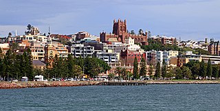
Newcastle is a metropolitan area and the second most populated city in the state of New South Wales, Australia. It includes the Newcastle and Lake Macquarie local government areas, and is the hub of the Greater Newcastle area, which includes most parts of the local government areas of City of Newcastle, City of Lake Macquarie, City of Cessnock, City of Maitland and Port Stephens Council.

Dubbo is a city in the Orana Region of New South Wales, Australia. It is the largest population centre in the Orana region, with a population of 43,516 at June 2021.
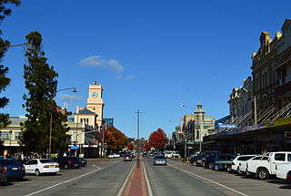
Goulburn is a regional city in the Southern Tablelands of the Australian state of New South Wales, approximately 195 kilometres (121 mi) south-west of Sydney, and 90 kilometres (56 mi) north-east of Canberra. It was proclaimed as Australia's first inland city through letters patent by Queen Victoria in 1863. Goulburn had a population of 23,835 at June 2018. Goulburn is the seat of Goulburn Mulwaree Council.

Tweed Heads is a town in New South Wales. It is located on the Tweed River in north-eastern New South Wales, Australia, in Tweed Shire, next to the border with Queensland and adjacent to its "twin town" of Coolangatta, which is a suburb of the Gold Coast. It is often referred to as a town where people can change time zones – even celebrate New Year twice within an hour – simply by crossing the street, due to its proximity to the Queensland border, and the fact that New South Wales observes daylight saving whereas Queensland does not.

Casino is a town in the Northern Rivers area of New South Wales, Australia, with a population of 10,914 people at the 2016 census. It lies on the banks of the Richmond River and is situated at the junction of the Bruxner Highway and the Summerland Way.

The Australian state of New South Wales has an extensive network of railways, which were integral to the growth and development of the state. The vast majority of railway lines were government built and operated, but there were also several private railways, some of which operate to this day.

The New South Wales Government Railways (NSWGR) was the agency of the Government of New South Wales that administered rail transport in New South Wales, Australia, between 1855 and 1932.

Cootamundra, nicknamed Coota, is a town in the South West Slopes region of New South Wales, Australia and within the Riverina. It is within the Cootamundra-Gundagai Regional Council. At the 2016 Census, Cootamundra had a population of 6,782. It is located on the Olympic Highway at the point where it crosses the Muttama Creek, between Junee and Cowra. Its railway station is on the Main Southern line, part of the Melbourne-to-Sydney line.

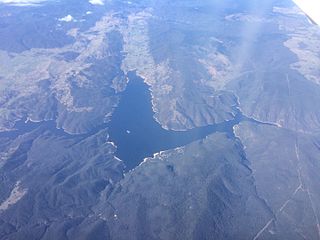
Wyangala Dam is a major gated rock fill with clay core embankment and gravity dam with eight radial gates and a concrete chute spillway across the Lachlan River, located in the south-western slopes region of New South Wales, Australia. The dam's purpose includes flood mitigation, hydro-power, irrigation, water supply and conservation. The impounded reservoir is called Lake Wyangala.

Newcastle railway station is a heritage-listed closed railway station on the Newcastle railway line at Newcastle, New South Wales, Australia. It was the main railway station and terminus station prior to the curtailment of the Newcastle railway line.
Burrinjuck Dam is a heritage-listed major gated concrete-walled gravity hydro-electric dam at Burrinjuck, Yass Valley Shire, New South Wales, Australia. It has three spillways across the Murrumbidgee River located in the South West Slopes region of New South Wales, Australia. The dam's purpose includes flood mitigation, hydro-power, irrigation, water supply and conservation. The impounded reservoir is called Lake Burrinjuck. It was designed by Lawrence Augustus Burton Wade and built from 1907 to 1927 by Lane & Peters, Sydney. It is also known as Barren Jack Dam and Barrenjack. The property was owned by Department of Planning and Infrastructure. It was added to the New South Wales State Heritage Register on 2 April 1999.

The Upper Nepean Scheme is a series of dams and weirs in the catchments of the Cataract, Cordeaux, Avon and Nepean rivers of New South Wales, Australia. The scheme includes four dams and two weirs, and a gravity-fed canal system that feeds into a large storage reservoir to provide water to the Macarthur and Illawarra regions, the Wollondilly Shire, and metropolitan Sydney. The four dams and associated infrastructure are individually listed on the New South Wales State Heritage Register.

The Public Transport Commission (PTC) was an agency of the Government of New South Wales responsible for the provision of rail, bus and ferry services in New South Wales, Australia from October 1972 until June 1980.

Wollondilly Shire is a periurban local government area adjacent to the south-western fringe of Sydney, parts of which fall into the Macarthur, Blue Mountains and Central Tablelands regions in the state of New South Wales, Australia. Wollondilly Shire was created by proclamation in the NSW Government Gazette on 7 March 1906, following the passing of the Local Government (Shires) Act 1905, and amalgamated with the Municipality of Picton on 1 May 1940.

The Hawkesbury River railway bridge is a heritage-listed railway bridge in New South Wales, Australia that carries the Main North railway line across the Hawkesbury River. It is located just north of the town of Brooklyn on the northern outskirts of Sydney. The railway bridge was to be the last link in a railway network that linked the state capitals Adelaide, Melbourne, Sydney and Brisbane and was a major engineering feat at the time. The original railway bridge was built in 1889 and replaced by the current bridge in 1946. The 1946 bridge was added to the New South Wales State Heritage Register on 2 April 1999.

The Dorrigo railway line is a closed railway line in the north of New South Wales, Australia. It branches from the North Coast line at Glenreagh.
The Culcairn to Holbrook railway line is a short, closed, railway line in New South Wales, Australia. The line ran from the Main South railway line at Culcairn for 26 km east to the town of Holbrook.

The Nepean River railway bridge is a heritage-listed railway bridge that carries the Main Southern railway line across Menangle Road and the Nepean River located at the outer south-western Sydney settlement of Menangle in the Wollondilly Shire local government area of New South Wales, Australia. It was designed by John Whitton as the Engineer-in-Chief, of the New South Wales Government Railways and NSW Department of Public Works. The railway bridge was built in 1863 by Messers Peto, Brassey and Betts. It is also known as Menangle rail bridge over Nepean River and Menangle Railway Bridge. The property was added to the New South Wales State Heritage Register on 2 April 1999.
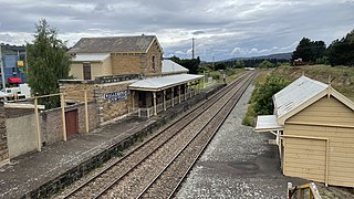
The Wallerawang railway station is a heritage-listed disused railway station located on the Main Western line in Wallerawang, City of Lithgow, New South Wales, Australia. It is also known as Wallerawang Railway Station and yard group. The property was added to the New South Wales State Heritage Register on 2 April 1999.

The Lachlan River railway bridge is a heritage-listed former railway bridge which carried the Blayney–Demondrille railway line over the Lachlan River at Cowra, Cowra Shire, New South Wales, Australia. It was designed by John Whitton in his capacity as Engineer-in-Chief for Railways. The bridge was built from 1886 to 1887 by contractors Fishburn & Co. It is also known as the Cowra Rail Bridge over Lachlan River and the Cowra Lattice Railway Bridge. The property is owned by RailCorp, an agency of the Government of New South Wales. It was added to the New South Wales State Heritage Register on 2 April 1999.
