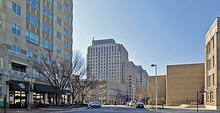
Reston is a census-designated place in Fairfax County, Virginia. Founded in 1964, Reston was influenced by the Garden City movement that emphasized planned, self-contained communities that intermingled green space, residential neighborhoods, and commercial development. The intent of Reston's founder, Robert E. Simon, was to build a town that would revolutionize post–World War II concepts of land use and residential/corporate development in suburban America. In 2018, Reston was ranked as the Best Place to Live in Virginia by Money magazine for its expanses of parks, lakes, golf courses, and bridle paths as well as the numerous shopping and dining opportunities in Reston Town Center.

Dandenong is a suburb of Melbourne, Victoria, Australia, 29 km south-east from the Melbourne CBD. Situated on the Dandenong Creek, it is 21.6 km from the Dandenong Ranges in eastern Victoria and completely unrelated in both location and nature. It is the administrative centre for the City of Greater Dandenong local government area. At the 2016 census, central Dandenong had a population of 29,906.

Cooma is a town in the south of New South Wales, Australia. It is located 114 kilometres (71 mi) south of the national capital, Canberra, via the Monaro Highway. It is also on the Snowy Mountains Highway, connecting Bega with the Riverina.

Terang is a town in the Western District of Victoria, Australia. The town is in the Shire of Corangamite and on the Princes Highway 212 kilometres (132 mi) south west of the state's capital, Melbourne. At the 2006 census, Terang had a population of 1,824. At the 2001 census, Terang had a population of 1,859. The population of Terang has since risen according to the 2011 Census; the population is now 2,348, of which 1,155 are male and 1,193 are female, with the median age being 44.

Mundubbera is a town and a locality in the North Burnett Region, Queensland, Australia. In the 2016 census, Mundubbera had a population of 1261 people.

Normanton is a small cattle town and coastal locality in the Shire of Carpentaria in Queensland, Australia. In the 2016 census, Normanton had a population of 1,210 people of whom 743 were Indigenous Australians.

Stettler is a town in east-central Alberta, Canada within the County of Stettler No. 6. It is located approximately 80 km (50 mi) east of Red Deer and 97 km (60 mi) north of Drumheller at the junction of Highway 12 and Highway 56 and approximately 183 km south of Alberta's capital city, Edmonton. The town is nicknamed "The Heart of Alberta."

Leongatha is a town in the foothills of the Strzelecki Ranges, South Gippsland Shire, Victoria, Australia, located 135 kilometres (84 mi) south-east of Melbourne. At the 2016 census, Leongatha had a population of 5,119.

Millet is a town in central Alberta, Canada, located approximately 40 kilometres (25 mi) south of Alberta's capital city of Edmonton. The town has won nationally in the Communities in Bloom competition and markets its beautiful setting.

Manjimup is a town in Western Australia, 307 kilometres (191 mi) south of the state capital, Perth. The town of Manjimup is a regional centre for the largest shire in the South West region of Western Australia. At the 2016 census, Manjimup had a population of 4,349.
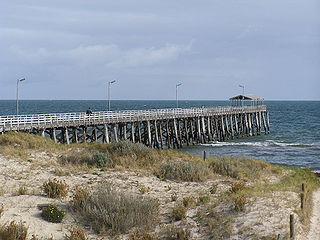
Grange is a coastal suburb of the City of Charles Sturt, in Adelaide, South Australia, located 11 kilometres from the Adelaide city centre.

Temora is a town in the north-east of the Riverina area of New South Wales, 418 kilometres (260 mi) south-west of the state capital, Sydney. At the 2016 census the urban population of Temora was 4,054.

Grong Grong is a small town that is located in the Riverina region of New South Wales, Australia. The town is situated on the Newell Highway, 23 kilometres (14 mi) east of Narrandera in the Shire of Narrandera.
Babinda is a small town and locality in the Cairns Region, Queensland, Australia. It is located 60 kilometres (37 mi) south of Cairns.

Culcairn is a town in the south-east Riverina region of New South Wales, Australia. Culcairn is located in the Greater Hume Shire local government area on the Olympic Highway between Albury and Wagga Wagga. The town is 514 kilometres (319 mi) south-west of the state capital, Sydney and at the 2006 census had a population of 1,120.
The Main Western Railway is a major railway in New South Wales, Australia. It runs through the Blue Mountains, Central West, North West Slopes and the Far West regions. It is 825 kilometres (513 mi) with 484 kilometres (301 mi) operational & 341 kilometres (212 mi) under construction & repairs.

Walgett Shire is a local government area in the Orana region of New South Wales, Australia. The northern boundary of the Shire is located adjacent to the border between New South Wales and Queensland. The town of Walgett is located on the Namoi River, nearby to its junction with the Barwon River and at the junction of the Kamilaroi Highway and the Castlereagh Highway.

Carmila is a town and coastal locality in the Isaac Region, Queensland, Australia.

Wallaville is a rural town and locality in the Bundaberg Region, Queensland, Australia. It is 372 kilometres (231 mi) north of the state capital, Brisbane and 43 kilometres (27 mi) south west of the regional centre of Bundaberg. In the 2016 census, Wallaville had a population of 410 people.

Paruna is a town in eastern South Australia. The town is located on the Browns Well Highway, where it crosses the former Barmera railway line, 237 kilometres (147 mi) east of the state capital, Adelaide.
