
Manilla is a small town in New South Wales, Australia, located on Fossickers Way 45 kilometres northwest of the regional city of Tamworth and 27 kilometres northeast of the historic village Somerton. Manilla is famous for its setting as a fishing, paragliding, and mountain biking area. The name Manilla comes from the Gamilaraay word 'Maneela', which is said to mean 'meeting of the rivers'.

Scone is a town in the Upper Hunter Shire in the Hunter Region of New South Wales, Australia. At the 2021 census, Scone had a population of 5,013 people. It is on the New England Highway north of Muswellbrook about 270 kilometres north of Sydney, and is part of the New England (federal) and Upper Hunter (state) electorates. Scone is in a farming area and is also noted for breeding Thoroughbred racehorses. It is known as the "Horse capital of Australia".

Eurobodalla Shire is a local government area located in the South Coast region of New South Wales, Australia. The Shire is located in a largely mountainous coastal region and situated adjacent to the Tasman Sea, the Princes Highway and the Kings Highway.

The Upper Hunter Shire is a local government area in the Upper Hunter Valley of New South Wales, Australia. The Shire was formed in May 2004 from the Scone Shire and parts of Murrurundi and Merriwa shires.

Junee is a medium-sized town in the Riverina region of New South Wales, Australia. The town's prosperity and mixed services economy is based on a combination of agriculture, rail transport, light industry and government services, and in particular correctional services. In 2021 Junee's urban population was 4,882.

Hornsby Shire is a local government area situated on the Upper North Shore as well as parts of the Hills District, of Sydney in the state of New South Wales, Australia. The shire stretches from the M2 Hills Motorway in the south to the Hawkesbury River town of Wisemans Ferry, some 53 kilometres (33 mi) to the north, making it the largest local government council in the Greater Sydney Metropolitan region by total area. As of the 2016 census the shire had an estimated population of 142,667.

Leeton Shire is a local government area in the Riverina region of New South Wales, Australia. The Shire is located adjacent to the Murrumbidgee River and falls within the Murrumbidgee Irrigation Area.
Kootingal is a town in New South Wales, Australia in the Tamworth Regional Council area. It is commonly called a satellite suburb of Tamworth because of its closeness and the fact that its residents use Tamworth's services. Founded as an Aboriginal mission, Kootingal traces its name roots to the local Aboriginal Kamilaroi language. At the 2021 census, Kootingal had a population of 2,313 people.

Moonbi is a village situated on the New England Highway 20 kilometres north of Tamworth, New South Wales, Australia. It is nestled at the foot of the Moonbi Range and is part of the Tamworth Regional Council local government area. Moonbi is located a few kilometres to the north of the town of Kootingal. At the 2006 census, Moonbi had a population of 357 people.

Wollondilly Shire is a periurban local government area, located on the south west fringe of the Greater Sydney area in New South Wales, Australia, parts of which fall into the Macarthur, Blue Mountains and Central Tablelands regions in the state of New South Wales, Australia. Wollondilly is seen as the transition between Regional NSW and the Greater Sydney Region, and is variously categorised as part of both. Wollondilly Shire was created by proclamation in the NSW Government Gazette on 7 March 1906, following the passing of the Local Government (Shires) Act 1905, and amalgamated with the Municipality of Picton on 1 May 1940.

Tamworth Regional Council is a local government area in the New England region of New South Wales, Australia. The area under administration is located adjacent to the New England Highway and the Main North railway line. It was established in March 2004 through the amalgamation of the former City of Tamworth with surrounding shires of Barraba, Manilla, Nundle and Parry.

Lockhart Shire is a local government area in the Riverina region of New South Wales, Australia. The Shire was created in 1906 and is an agricultural and pastoral area.
Cooks Hill is an inner city suburb of Newcastle, New South Wales, Australia. It is typified by its tree lined streets, rows of Victorian terrace housing, turn of the century timber cottages and corner pubs.

Cockburn River is a perennial river that is part of the Namoi catchment within the Murray–Darling basin, located in the Northern Tablelands district of New South Wales, Australia.

Walcha Road railway station is a heritage-listed railway station located on the Main Northern line in Walcha Road, Walcha Shire, New South Wales, Australia. The railway station serves the village of Walcha Road and town of Walcha, opening on 2 August 1882 when the line was extended from Kootingal to Uralla. It is also known as Walcha Road Railway Station and yard group. The property was added to the New South Wales State Heritage Register on 2 April 1999.

The Armidale Region is a local government area in the New England and Northern Tablelands regions of New South Wales, Australia. This area was formed in 2016 from the merger of the Armidale Dumaresq Shire with the surrounding Guyra Shire.

Murrumbidgee Council is a local government area in the Riverina region of New South Wales, Australia. This area was formed in 2016 from the merger of the Murrumbidgee Shire and the Jerilderie Shire.
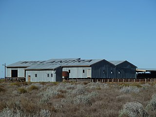
Willandra Homestead is a heritage-listed homestead in the Willandra National Park, Carrathool Shire, New South Wales, Australia. It was designed by Laird & Buchan and built in 1918 by Frederick Coulson. The property is owned by the New South Wales Office of Environment and Heritage. It was added to the New South Wales State Heritage Register on 2 April 1999.

Rous Lench is a heritage-listed farm and homestead located at Denman Road, Muswellbrook in the Muswellbrook Shire local government area of New South Wales, Australia. It was built from 1875 to 1895. It was added to the New South Wales State Heritage Register on 2 April 1999.

The Tenterfield Post Office is a heritage-listed post office located at 225 Rouse Street, Tenterfield, Tenterfield Shire, New South Wales, Australia. It was designed by NSW Colonial Architect's Office under James Barnet and built from 1881 to by T. & J. McGuaran, later T. A. Lewis. It is also known as the Tenterfield Post Office and Quarters. The property is owned by Australia Post. It was added to the New South Wales State Heritage Register on 17 December 1999.

