Loddon Valley Highway

Last updated

Loddon Valley Highway

Australia Victoria location map.svg
Red pog.svg
North end
Red pog.svg
South end
Coordinates
General information
TypeHighway
Length124 km (77 mi) [1]
Gazetted September 1915 (as Main Road) [2]
1946 (as State Highway) [3]
Route number(s) AUS Alphanumeric Route B260.svg B260 (1998–present)
Former
route number
Australian state route 141.svg State Route 141 (1986–1998)
Major junctions
North endAUS Alphanumeric Route B400.svg Murray Valley Highway
Kerang, Victoria
 AUS Alphanumeric Route C267.svg Boort–Pyramid Road
South endAUS Alphanumeric Route A79.svg Calder Highway
Ironbark, Bendigo
Location(s)
Region Loddon Mallee [4]
Major settlements Durham Ox, Serpentine, Eaglehawk
Highway system

Loddon Valley Highway runs roughly north-west from Bendigo to Kerang. [5] It constitutes part of the direct route from Melbourne to the popular Murray River holiday areas around Swan Hill.

Contents

Route

Loddon Valley Highway commences at the intersection with Murray Valley Highway just south of the fringes of Kerang and heads in a southerly direction as a dual-lane single carriageway rural highway, running parallel to the Loddon River a short distance to the west of the road for much of its length. It continues south through Durham Ox until it reaches Serpentine, where it veers more to the south-east away from the river course, passing through the hills around Eaglehawk on the outskirts of Greater Bendigo, before it eventually terminates at the intersection with Calder Highway in Ironbark, in the north-western suburbs of Bendigo.

History

Within Victoria, the passing of the Country Roads Act of 1912 [6] through the Parliament of Victoria provided for the establishment of the Country Roads Board (later VicRoads) and their ability to declare Main Roads, taking responsibility for the management, construction and care of the state's major roads from local municipalities. Bendigo-Serpentine Road was declared a Main Road from Bendigo to Yarraberb on 20 September 1915, [2] and Loddon Valley Road from Kerang through Durham Ox to Serpentine was declared a Main Road in the 1937/38 financial year. [7]

The passing of the Highways and Vehicles Act of 1924 [8] provided for the declaration of State Highways, roads two-thirds financed by the State government through the Country Roads Board. Loddon Valley Highway was declared a State Highway in 1946, [3] from Kerang via Serpentine to Bendigo, subsuming the original declarations of Loddon Valley Road and Bendigo-Serpentine Road as Main Roads.

Loddon Valley Highway was signed as State Route 141 between Kerang and Bendigo in 1986; with Victoria's conversion to the newer alphanumeric system in the late 1990s, this was replaced by route B260.

The passing of the Road Management Act 2004 [9] granted the responsibility of overall management and development of Victoria's major arterial roads to VicRoads: in 2004, VicRoads re-declared the road as Loddon Valley Highway (Arterial #6630), beginning at Murray Valley Highway at Kerang and ending at Calder Highway in Ironbark, Bendigo. [5]

Major intersections

LGALocation [1] [5] km [1] miDestinationsNotes
Gannawarra Kerang 0.00.0AUS Alphanumeric Route B400.svg Murray Valley Highway (B400)  Kerang, Swan Hill, Cohuna, Echuca Northern terminus of highway and route B260
Loddon Durham Ox 40.625.2AUS Alphanumeric Route C267.svg Boort–Pyramid Road (C267 east)  Pyramid Hill, Cohuna Concurrency with route C267
42.326.3AUS Alphanumeric Route C267.svg Boort–Pyramid Road (C267 west)  Boort, Wycheproof
Jarklin 52.532.6AUS Alphanumeric Route C334.svg Boort–Mitiamo Road (C334)  Mitiamo, Echuca
Serpentine 75.246.7AUS Alphanumeric Route C274.svg Bridgewater–Serpentine Road (C274)  Bridgewater On Loddon, Dunolly
Greater Bendigo Woodvale 115.571.8 Swan Hill railway line
Eaglehawk 119.174.0AUS Alphanumeric Route C336.svg Sailors Gully Road (Bendigo–Pyramid Road) (C336)  Pyramid Hill
California Gully 120.274.7 Swan Hill railway line
120.374.8AUS Alphanumeric Route C329.svg Sandhurst Road (C329)  Bendigo, Heathcote Traffic light intersection
Long Gully 122.075.8AUS Alphanumeric Route C333.svg Holdsworth Road (C333)  White Hills
122.776.2AUS Alphanumeric Route C323.svg Creeth Street (Golden Square–Long Gully Road) (C323)  West Bendigo, Golden Square Traffic light intersection
Ironbark 123.876.9AUS Alphanumeric Route A79.svg Calder Highway (A79)  Marong, Mildura, Bendigo, Melbourne Southern terminus of highway and route B260 at traffic light intersection

See also

Related Research Articles

Melton Highway links Melbourne's outer north-western suburbs of Melton and Taylors Lakes, connecting the Western Freeway and Calder Freeway to provide a more-direct route between Ballarat and Melbourne and Essendon airports; it has a Victorian route designation of C754.

<span class="mw-page-title-main">Calder Highway</span> Highway in Victoria

Calder Highway is a rural highway in Australia, linking Mildura and the Victoria/New South Wales border to Bendigo, in North Central Victoria. South of Bendigo, where the former highway has been upgraded to freeway-standard, Calder Freeway links to Melbourne, subsuming former alignments of Calder Highway; the Victorian Government completed the conversion to freeway standard from Melbourne to Bendigo on 20 April 2009.

<span class="mw-page-title-main">Maroondah Highway</span> Highway in Victoria, Australia

Maroondah Highway is a major east–west thoroughfare in the eastern suburbs of Melbourne, and a highway connecting the north-eastern fringes of Melbourne to Mansfield, at the lower alpine region of Victoria, Australia.

<span class="mw-page-title-main">Mallee Highway</span>

Mallee Highway is a highway connecting Tailem Bend in south-eastern South Australia and Piangil in north-western Victoria, running mostly across the Mallee plains. It forms part of the shortest route between Adelaide and Sydney.

Northern Highway is a rural highway in northern Victoria, linking Echuca on the banks of the Murray River with Beveridge a short distance north of the northern suburban fringes of Melbourne. In conjunction with McIvor Highway, it provides an important link between Melbourne and Bendigo. It forms a significant freight route providing access to markets and ports in Melbourne and the rural primary production areas of the Murray Valley and southern New South Wales, and serves a number of agricultural and tourism-related industries along its length.

<span class="mw-page-title-main">Sunraysia Highway</span> Highway in Victoria

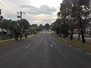
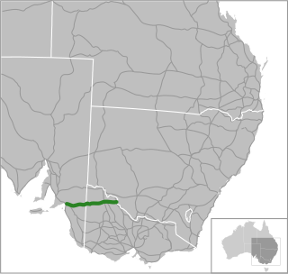
Sunraysia Highway is a 330 kilometres (205 mi) north–south rural highway in western Victoria, linking Ouyen to the north-western Ballarat suburb of Mitchell Park, and acts as a secondary route to Calder Highway, the main route between Melbourne and Mildura. It serves a number of important industries in the region such as agriculture, viticulture, food processing, winemaking and tourism. It forms an important link for these industries to markets and ports in the south of Victoria and South Australia.

<span class="mw-page-title-main">Goulburn Valley Highway</span>

Goulburn Valley Highway is a highway located in Victoria, Australia, linking Tocumwal on the Murray River through North Central Victoria to Eildon. The section north of the Hume Freeway is part of the Melbourne to Brisbane National Highway and is the main link between these two cities, as well as a major link between Victoria and inland New South Wales. It is also the most direct route between Melbourne and the major regional centre of Shepparton in Victoria.

<span class="mw-page-title-main">Murray Valley Highway</span> Highway in Victoria and New South Wales

Murray Valley Highway is a 663-kilometre (412 mi) rural highway located in Victoria, Australia, between Euston, New South Wales and Corryong, Victoria. The popular tourist route mostly follows the southern bank of the Murray River and effectively acts as the northernmost highway in Victoria. For all but the western end's last three kilometres, the highway is allocated route B400.

<span class="mw-page-title-main">Loddon River</span> River in Victoria, Australia

The Loddon River, an inland river of the north–central catchment, part of the Murray-Darling basin, is located in the lower Riverina bioregion and Central Highlands and Loddon Mallee regions of the Australian state of Victoria. The headwaters of the Loddon River rise on the northern slopes of the Great Dividing Range east of Daylesford and descend to flow north into the Little Murray River, near Swan Hill. The river is impounded by the Cairn Curran and Laanecoorie reservoirs.

McIvor Highway is a short Victorian highway (44 km) linking Bendigo and Heathcote. Together with Hume Freeway and Northern Highway, it provides an alternative route between Melbourne and Bendigo. The name 'McIvor' refers to the original name of the Heathcote region, used during the Victorian Gold Rush.

<span class="mw-page-title-main">Borung Highway</span> Highway in western Victoria, Australia

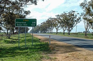
Borung Highway is a 138 kilometre rural highway in western Victoria, running in a west–east direction from Dimboola in the west to Charlton in the east.

<span class="mw-page-title-main">Dandenong Valley Highway</span> Highway in Victoria

The Dandenong Valley Highway is an urban highway stretching almost 40 kilometres from Bayswater in Melbourne's eastern suburbs to Frankston in the south. This name covers many consecutive streets and is not widely known to most drivers, as the entire allocation is still best known as by the names of its constituent parts: Stud Road, Foster Street, Dandenong-Frankston Road, Dandenong Road West and Fletcher Road. This article will deal with the entire length of the corridor for sake of completion, as well to avoid confusion between declarations.

Midland Highway is a major rural highway linking major towns in Victoria, beginning from Geelong and winding through country Victoria in a large arc through the cities of Ballarat, Bendigo and Shepparton, eventually reaching Mansfield at the foothills of the Victorian Alps.

<span class="mw-page-title-main">Pyrenees Highway, Victoria</span> Highway in western Victoria, Australia

Pyrenees Highway is a rural highway in western Victoria, Australia, linking Ararat to Elphinstone. It was named after the Pyrenees ranges, the set of low mountain ridges the road travels through.

Melba Highway is a semi-rural highway that connects the outer eastern suburbs of Melbourne to the town of Yea, in Victoria's Upper Goulburn region. It is named after Dame Nellie Melba, a famed Australian opera singer of the early 20th century, whose former country estate lies at the southern end of the highway in Coldstream.

<span class="mw-page-title-main">Mount Alexander Road</span> Road in Melbourne, Victoria

Mount Alexander Road is a major road in Melbourne's inner northern suburbs, connecting the northern edges of the city district to just south of Essendon Airport. It was named after its original destination: the Gold Fields of Mount Alexander, now known as Castlemaine.

<span class="mw-page-title-main">Omeo Highway</span> Highway in Victoria

Omeo Highway is a 163 kilometre rural highway in eastern Victoria, Australia, connecting Tallangatta on Lake Hume in north-east Victoria to Bairnsdale in East Gippsland, over parts of the Victorian Alps.

<span class="mw-page-title-main">Henty Highway</span> Highway in Victoria

Henty Highway is a rural highway in western Victoria, Australia, linking Lascelles in the Wimmera region, to Portland on the state's soith-western coast. It was named in honour of Edward Henty, a British colonist regarded as the first permanent European settler of the Port Phillip District, in the town eventually named Portland.

Kiewa Valley Highway is a rural highway which traverses the Kiewa Valley near the alpine regions of Victoria, Australia, connecting the eastern Wodonga suburb of Bandiana to Mount Beauty, at the foot of Mount Bogong in the Alpine National Park.

<span class="mw-page-title-main">Wimmera Highway</span> Highway in Victoria and South Australia

Wimmera Highway is a 345 kilometre rural highway that runs predominately through the Wimmera region of western Victoria, after which the highway is named. It links the towns of Marong, Victoria, just to the west of the major regional centre of Bendigo in Victoria, and Naracoorte, in the south-eastern corner of South Australia.

References

  1. 1 2 3 Google (15 July 2024). "Loddon Valley Highway" (Map). Google Maps . Google. Retrieved 15 July 2024.
  2. 1 2 "Victorian Government Gazette". State Library of Victoria. 16 August 1915. p. 3123. Retrieved 15 July 2024.
  3. 1 2 "Country Roads Board Victoria. Thirty-Third Annual Report: for the year ended 30 June 1946". Country Roads Board of Victoria. Melbourne: Victorian Government Library Service. 3 December 1946. p. 5.
  4. "Victoria's Regions". Regional Development Victoria. Victoria State Government. 11 August 2021. Retrieved 16 June 2022.
  5. 1 2 3 VicRoads. "VicRoads – Register of Public Roads 2024" (PDF). Government of Victoria. p. 940. Archived from the original on 19 June 2024. Retrieved 19 June 2024.
  6. An Act relating to Country Roads State of Victoria, 23 December 1912
  7. "Country Roads Board Victoria. Twenty-Fifth Annual Report: for the year ended 30 June 1938". Country Roads Board of Victoria. Melbourne: Victorian Government Library Service. 24 November 1938. p. 14.
  8. An Act to make further provision with respect to Highways and Country Roads Motor Cars and Traction Engines and for other purposes State of Victoria, 30 December 1924
  9. State Government of Victoria. "Road Management Act 2004" (PDF). Government of Victoria. Archived (PDF) from the original on 18 October 2021. Retrieved 19 October 2021.