Spalding railway line

Last updated

Spalding railway line
Clare Railway Station(GN02061).jpg
The railway station at Clare in September 1918, a month after the first section of the Spalding line opened to Clare.
Overview
StatusClosed
Termini
Continues from Peterborough line
Service
System South Australian Railways
Operator(s) South Australian Railways
Australian National
History
Opened Riverton-Clare: 5 July 1918
Clare-Spalding: 9 January 1922
Closed17 April 1984
Technical
Line length83.8 km (52.1 mi)
Track gauge 1,600 mm (5 ft 3 in)
Route map

Contents

BSicon exKBHFa.svg
Spalding
BSicon exhKRZWae.svg
BSicon exBHF.svg
Andrews
BSicon exHST.svg
Hilltown
BSicon exHST.svg
Barinia siding
BSicon exHST.svg
Whitehut siding
BSicon exBHF.svg
Clare
BSicon exHST.svg
Clare Showground siding
BSicon exHST.svg
Sevenhill
BSicon exHST.svg
Tatkana siding
BSicon exHST.svg
Penwortham
BSicon exBHF.svg
Watervale
BSicon exHST.svg
Leasingham
BSicon exHST.svg
Milkurri siding
BSicon exhKRZWae.svg
BSicon exBHF.svg
Auburn
BSicon exWBRUCKE2.svg
Rices Creek
BSicon exWBRUCKE2.svg
Pine Creek
BSicon exABZg+l.svg
BSicon exCONTfq.svg
BSicon exBHF.svg
BSicon exCONTf.svg

BSicon STRq.svg
BSicon exSTRq.svg
BSicon uSTRq.svg
BSicon uexSTRq.svg
BSicon fSTRq.svg
BSicon fexSTRq.svg

The Spalding railway line was a railway line on the South Australian Railways network which branched from the Peterborough line at Riverton and passed through the Clare Valley to Spalding. The line opened from Riverton to Clare on 5 July 1918, being extended to Spalding on 9 January 1922. The cessation of railway services was a consequence of the Ash Wednesday bushfires in February 1983, which caused major damage to infrastructure between Sevenhill and Penwortham. The line was formally closed on 17 April 1984. [1]

Campaign for the railway

It was a railway that had been mooted in the 1860s, [2] but was deemed to be too costly on account of the hilly nature of the Clare region. In 1870 railways were constructed to the east Burra, and the west (Hoyleton) of the Clare region. In 1875 a Railway Commission was established to recommend appropriate expansion of the South Australian railway network, but recommended against a branch line to Clare because no point in the region was more than 15 miles (24 km) from a railway station. The communities of Clare, Watervale and Auburn continued to agitate for the railway. At the start of the 1910s, their cause was championed by Sir Richard Butler, who had briefly been South Australian Premier, and was then Commissioner of Public Works in Archibald Peake's administration. A Royal Commission examined the proposal and determined that a branch-line to Clare would not generate revenue sufficient to cover costs, but extending the line further north towards Spalding would facilitate closer settlement of the pastoral estates, which would in turn generate more revenue. The Riverton to Spalding Railway Act was passed in 1913.

Construction

The line was built with economies that doomed it to inefficient operation. [3] There were tight curves (15 chains (990 ft; 300 m) radius north of Clare), 1:60 grades, second-hand 60 lb (27 kg) rails, and reinforced concrete bridges that were designed for light axle loading. When larger locomotives were introduced on the South Australian Railways in 1926, the Spalding line was unable to carry their greater weight. The motive power up to 1950 was mainly Rx class engines, with the occasional Q class and S class. Commencing early 1951, the line was worked mainly by 750 class locomotives. From 1960 the line was worked by 830 class diesel-electric locomotives.

There was a major bridge over the Broughton River, just south of Spalding. It still stands, and in 1993 it was heritage [4] listed. That listing was a consequence of the inclusion of the bridge in the 1985 book by Colin O'Connor "Spanning Two Centuries - Historic Bridges of Australia". O'Connor's [5] book contains inaccuracies in relation to this bridge. It attributes its design to Alexander Moncrieff, but the contract drawing [6] is signed by Alex's brother Joseph. When the bridge was designed, Alex Moncrieff had not worked for the South Australian Railways for two years. Its 5-arch design was, by engineering standards, more than a decade obsolete when the contract was signed in 1918. Australia's expert on ferro-concrete construction, John Monash, had abandoned that style of bridge by 1906. When the Broughton River bridge was completed in 1919 there was a dispute over payments to the contractor, Joseph Dixon. The matter went to the High Court of Australia, which was critical of Joseph Moncrieff's handling of the contract, yet by a majority the High Court found in favour of the South Australian Railways.

Safeworking

From 1918 to 1922, the safeworking system was the telephone block. With the opening of the line to Spalding in 1922, the line was worked under permissive block conditions. From January 1944 the line was worked by the train order system, operated by Train Control in Adelaide. [7]

Rail services

In 1924 the South Australian Railways began using Model 55 Brill petrol railcars to provide passenger services on rural branch-lines, with Clare being the first destination, commencing on 24 February. Two days earlier, South Australian Premier Sir Henry Barwell hosted a group of officials and members of parliament on a demonstration run to Clare. By the end of 1924, the new railcars had become known in popular parlance as "Barwell Bulls", which was a term coined by one of Barwell's political opponents, with reference to the penetrating bovine sound of the railcar's air-horn. [8]

In 1927 the larger Model 75 Brill railcars operated the passenger service, and continued until 1954. On 24 May 1954, the railcar service was replaced by a co-ordinated road-bus service serving Jamestown and the towns along the Spalding railway line, to connect with trains at Riverton. The main source of outward freight on the line was bulk grain railed from Andrews. However, the rail-haul distance for transporting the grain to the terminal at Port Adelaide was considerably longer than the distance by road haulage to Wallaroo. During the 1970s there was a marked drop in the tonnage of grain railed from Andrews. Spalding became an unattended station in January 1975, [9] and then in July 1978, soon after Australian National Railways took over South Australian country operations, Andrews became the effective terminus, [10] because Spalding was deleted from the Working timetable. The track was lifted in 1989.

The Riesling Trail

In October 1992 the Clare Valley Winemakers Association held a Creative Think Day intended to find a way to distinguish the region's Riesling wine. [11] Tony Brady of Wendouree Cellars suggested a trail be built using the old railway formation, and that it be called the Riesling Trail. He was supported by Evan Hiscock of Petaluma Wines. The proposal gained support from Terry Lavender of the State's Office of Recreation and Sport. In May 1994, two trial sections of The Riesling Trail were officially opened - Sevenhill to Watervale, and Riverton to Rhynie. The Clare Valley Winemakers Association continued to drive development of the Trail, and the section between Clare and Auburn was officially launched on 7 November 1998. In 1999 a community management committee was established. The 19 kilometres (12 mi) section from Riverton through Rhynie to Auburn was subsequently redeveloped as the Rattler Rail Trail and opened in 2010. The original 33 km (21 mi) section from Auburn through the Clare Valley to Clare and beyond was extended northwards to the former Barinia siding, and was opened in November 2009. [12]

A committee in Clare is organising events and displays to mark the centenary of the official ceremony of the opening of the railway to Clare, performed by His Excellency, the Governor, Sir Henry Galway, on 4 July 1918. A book on the history of the railway is being prepared, and is planned to be released in time for the centenary.

Related Research Articles

<span class="mw-page-title-main">Clare Valley wine region</span>

The Clare Valley wine region is one of Australia's oldest wine regions, best known for Riesling wines. It lies in the Mid North of South Australia, approximately 142 km north of Adelaide. The valley runs north-south, with Horrocks Highway as the main thoroughfare.

<span class="mw-page-title-main">Rail transport in South Australia</span> Rail transport in South Australia

The first railway in colonial South Australia was a line from the port of Goolwa on the River Murray to an ocean harbour at Port Elliot, which first operated in December 1853, before its completion in May 1854.

<span class="mw-page-title-main">Riverton, South Australia</span> Town in South Australia

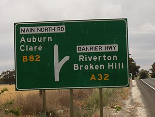
Riverton is a small town in the Mid North of South Australia, in the Gilbert Valley. It is situated on the Gilbert River, from which the town derives its name. Both the Gilbert Valley and Gilbert River were named after the South Australian pioneer Thomas Gilbert. Riverton was first settled in 1856, as a settlement along the bullock track from the mining town of Burra to the capital city Adelaide. It grew from a plan designed by a James Masters who had established the nearby town of Saddleworth. The streets of Riverton received their names chiefly from James Masters and his friends. They commemorate persons notable in the history of the district or the state. At the 2011 census, Riverton had a population of 810. Including the rural areas surrounding the town, the population was 1213.

<span class="mw-page-title-main">Riesling Trail</span> Walking and cycling track in South Australia

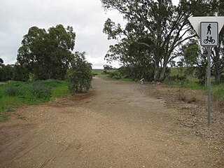
The Riesling Trail is a 35 kilometres long walking and cycling track located in the Clare Valley, South Australia. Established for recreational purposes, it runs between Auburn and Clare, passing through several towns and villages along the way, including Leasingham, Watervale, Penwortham and Sevenhill. The trail is named after Riesling, the most important white grape variety in the Clare Valley wine region. It continues 8 kilometres north of Clare to the area known as Barinia.

<span class="mw-page-title-main">Watervale, South Australia</span> Town in South Australia

Watervale is a town on the Horrocks Highway in the Clare Valley, South Australia, approximately 9 kilometres north of Auburn and 15 kilometres south of Clare. It is surrounded by a number of small wineries and several B&Bs. The Riesling Trail runs past the town to the west, between the Highway and the Skilly Hills. The town has a number of 19th-century heritage buildings, including the former Stanley Grammar School, which now provides private bed and breakfast accommodation.

<span class="mw-page-title-main">Penwortham, South Australia</span> Town in South Australia

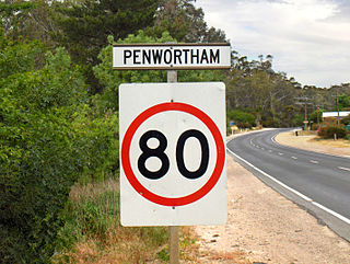
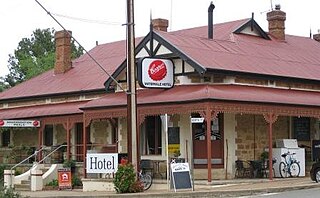
Penwortham is a small town in the Clare Valley, South Australia, along the Horrocks Highway, approximately 10 kilometres south of Clare and 14 kilometres north of Auburn.

<span class="mw-page-title-main">Clare and Gilbert Valleys Council</span> Local government area in South Australia

The Clare and Gilbert Valleys Council is a local government area located in the Yorke and Mid North region of South Australia. The council was founded on 1 July 1997 with the amalgamation of the District Council of Clare, the District Council of Riverton and the District Council of Saddleworth and Auburn. The council seat is located at Clare; it also maintains branch offices at Riverton and Saddleworth.

<span class="mw-page-title-main">Clare, South Australia</span> Town in South Australia

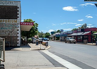
The town of Clare is located in South Australia in the Mid North region, 136 km north of Adelaide. It gives its name to the Clare Valley wine and tourist region.

<span class="mw-page-title-main">Sevenhill, South Australia</span> Town in South Australia

The Australian monastic town of Sevenhill is in the Clare Valley of South Australia, approximately 130 km north of Adelaide. The town was founded by members of the Jesuit order in 1850. The name, bestowed by Austrian Jesuit priest Aloysius Kranewitter, is in homage to the seven hills of Rome.

<span class="mw-page-title-main">Spalding, South Australia</span> Town in South Australia

Spalding is a town located north of the Clare Valley in South Australia, Australia. At the 2016 census, Spalding had a population of 215.

<span class="mw-page-title-main">Saddleworth, South Australia</span> Town in South Australia

Saddleworth is a small town in the Mid North region of South Australia. The town is situated on the Gilbert River and along with neighbouring towns of Riverton, Rhynie and Tarlee the local area is known as the Gilbert Valley. The town is bisected by the Barrier Highway. At the 2016 census, Saddleworth had a population of 470.

<span class="mw-page-title-main">Healesville railway line</span> Partially closed railway line in Melbourne, Australia

The Healesville railway line, in Melbourne, Australia, was the non-electrified continuation of the suburban Lilydale line, extending into the Yarra Valley. The line closed in the 1980s, but a heritage railway group, the Yarra Valley Railway, is working to retain part of the line between Yarra Glen and Healesville.

<span class="mw-page-title-main">Rhynie, South Australia</span> Town in South Australia

Rhynie is a small town in South Australia, halfway between Tarlee and Auburn, along the Horrocks Highway. It was surveyed and founded in 1859.

<span class="mw-page-title-main">Rattler Rail Trail</span>

The Rattler Rail Trail is a 19 km (12 mi) rail trail which joins onto the southern end of the Riesling Trail at Auburn, South Australia. Following the route of the former Spalding railway line, the trail takes its name from the rattling old train that used to ply the route. The Rattler Rail Trail passes through farming land as it wends its way to Riverton via Rhynie. Bike hire is available in the town of Auburn.

Grosset Wines is an Australian winery based in the Clare Valley wine region of South Australia.

The locality of Barinia is situated in South Australia in the Mid North region, approximately 10 km north of Clare. It was a railway siding on the Spalding railway line, which closed in 1984. In November 2009 it became the northern terminus of the Riesling Trail, which utilises the route of the former railway.

<span class="mw-page-title-main">Clare Valley</span> Region in South Australia

The Clare Valley is a valley located in South Australia about 100 kilometres north of Adelaide in the Clare and Gilbert Valleys council area. It is the river valley formed by the Hutt River but is also strongly associated with the roughly parallel Hill River. The valley is traversed by the Horrocks Highway and the towns in the valley along that route from south to north are Auburn, Leasingham, Watervale, Penwortham, Sevenhill and Clare. The geographical feature has given rise to the Clare Valley wine region designation, a notable winegrowing region of Australia.

<span class="mw-page-title-main">Roseworthy–Peterborough railway line</span> Former railway line in South Australia

The Roseworthy–Peterborough railway line was a railway line on the South Australian Railways network. It extended from a junction at Roseworthy on the Morgan railway line through Hamley Bridge, Riverton, initially to Tarlee, then extended in stages to Peterborough.

<span class="mw-page-title-main">Hundred of Gilbert</span> Cadastral in South Australia

The Hundred of Gilbert is a cadastral unit of hundred in the northern Mount Lofty Ranges including the town of Riverton. It is one of the nine hundreds of the County of Light. It was proclaimed in 1851 by Governor Henry Young and named after the Gilbert River, which flows from north to south through the hundred. The river, in turn, was named in honour of South Australian pioneer Thomas Gilbert.

References

  1. Quinlan, Howard; Newland, John (2000). Australian Railway Routes 1854 - 2000. Redfern: Australian Railway Historical Society. p. 55. ISBN   0-909650-49-7.
  2. Noye, Robert (1975). Clare A District History. Coromandel Valley: Lynton. p. 169. ISBN   0-86946-144-3.
  3. Jennings, Reece (1973). W.A. Webb South Australian Railways Commissioner 1922 - 1930 A Political,Economic and Social Biography. North Plympton: Nesfield Press. p. 39. ISBN   0-9599230-0-4.
  4. South Australia Heritage Places database State Heritage Id 14607
  5. O'Connor, Colin (1985). Spanning Two Centuries - Historic Bridges of Australia. St. Lucia: University of Queensland Press. p. 162. ISBN   0-7022-1798-0.
  6. SAR Contract No. 23/1918 Drawing No. 33378/411/46
  7. Egan, Des (2007). "Modelling the Railways of South Australia". p. 1.622.{{cite magazine}}: Cite magazine requires |magazine= (help)
  8. Wilson, John (March 2014). "Catchpoint Magazine". National Railway Museum. p. 31.{{cite magazine}}: Cite magazine requires |magazine= (help)
  9. "W.N. 1/75". South Australian Railways Weekly Notices. 1975.
  10. "ANR changes to Working Timetables". The Recorder, Australian Railway Historical Soc. SA Div. Inc: 151. 1978.
  11. Rhodes, Therese (4 November 2016). Thesis for Master in Environmental Management and Sustainability (Thesis). University of South Australia. p. appendix B.
  12. "Riesling Trail Location" . Retrieved 12 November 2015.