
Marion is a suburb in the City of Marion, around 10 kilometres (6.2 mi) south-west of the city centre of Adelaide, the capital of South Australia. Founded as a rural village in 1838 on the banks of the Sturt River, Marion was found to have rich soil and the population expanded rapidly. Colonel William Light laid out the plan for the village, as he had done with the City of Adelaide itself.

Woodville is a suburb of Adelaide, situated about 8 km (5 mi) north-west of the Adelaide city centre. It lies within the City of Charles Sturt. The postcode of Woodville is 5011. Woodville is bound by Cheltenham Parade to the west, Torrens Road to the north, Port Road to the south and Park Street to the east, excluding the area of Cheltenham Park Racecourse. The population was 2,180 at the 2021 Australian census.

The City of Charles Sturt is a local government area in the western suburbs of Adelaide, South Australia, stretching to the coast.

Ferryden Park is a north-western suburb of Adelaide 6.3 km from the central business district, in the state of South Australia, Australia. Situated in the City of Port Adelaide Enfield local government area, it is adjacent to Kilkenny, Angle Park, Woodville Gardens, Croydon Park, and Regency Park. It is bounded to the north by Murray Street, west by Liberty Grove and Hassell Street, south by Regency Road and to the east by Days Road.

Woodville Gardens is a north-western suburb of Adelaide 9 km from the CBD, in the state of South Australia, Australia and falls under the City of Port Adelaide Enfield. It is adjacent to Woodville North, Mansfield Park, Ferryden Park, and Kilkenny. The post code for Woodville Gardens is 5012. It is bounded to the south by First Avenue, and to the east by Liberty Grove, and to the west by Hanson Road.

Athol Park is a north-western suburb of Adelaide, South Australia. It is located in the City of Charles Sturt.

Woodville North is a north-western suburb of Adelaide 10 km from the Adelaide city centre, in the state of South Australia, Australia and falls under the City of Charles Sturt. The post code for Woodville North is 5012. It is adjacent to Pennington, Athol Park, Woodville Gardens, Mansfield Park, Woodville and Kilkenny. It is bordered to the east by Hanson Road to the west by Carlton Crescent, to the south by Torrens Road and to the north by Hamilton Road. The suburb is residential, apart from an industrial pocket to the northwest.

West Lakes is western suburb of Adelaide, South Australia, within the City of Charles Sturt.
Woodville South is a suburb of Adelaide, South Australia. It lies within the City of Charles Sturt.

Henley Beach is a coastal suburb of Adelaide, South Australia in the City of Charles Sturt.
Mansfield Park is a north-western suburb of Adelaide 10 km (6.2 mi) from the CBD, in the state of South Australia, Australia and falls under the City of Port Adelaide Enfield. It is adjacent to Wingfield, Angle Park, Woodville Gardens, and Athol Park. The postcode for Mansfield Park is 5012. It is bounded to the north by Grand Junction Road, and to the west by Hanson Road. It is named after the Mansfield in East Ayrshire, Scotland.
Kidman Park is a western suburb of Adelaide, South Australia. It lies within the City of Charles Sturt council area.
Albert Park is a suburb of Adelaide, South Australia. It is located in the City of Charles Sturt.
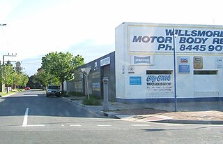
Woodville West is a suburb of Adelaide, situated about 9 kilometres northwest of the Central Business District. It lies within the City of Charles Sturt. The postcode of Woodville West is 5011. Woodville West is bounded by the railway line and Port Road in the north, Findon Road in the east, Trimmer Parade, Todville Street and Minns Street East in the south, and Frank Mitchell Park, Agnes Street and the railway line in the west. As of 2011, Renewal SA and the City of Charles Sturt have been implementing the Woodville West Neighbourhood Renewal Project, which involves an $130m property development.

Kilkenny is an inner north-western suburb of Adelaide, South Australia. It is located in the City of Charles Sturt. It is named after Kilkenny, Ireland.
Vale Park is a suburb of Adelaide in the Town of Walkerville, South Australia. It is located northeast of the Adelaide city centre between North East Road and the River Torrens, astride Ascot Avenue, part of the A17 highway which is the major eastern ring route bypass of Adelaide.

Seaton is a suburb of Adelaide, South Australia, located in the western suburbs near Findon, Grange and West Lakes. Seaton is home to the Royal Adelaide Golf Club.
Hendon is a north-western suburb of Adelaide, South Australia, 9.8 km from the Adelaide city centre. It is located in the City of Charles Sturt.
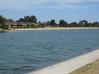
West Lakes Shore is a western suburb of Adelaide, South Australia. It lies within the City of Charles Sturt council area. Developed in the 1970s as a public-private joint venture, it's noted for its manmade tidal lake.
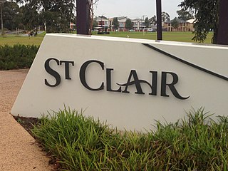
St Clair is a suburb of Adelaide, South Australia, and administered by the City of Charles Sturt. St Clair is geographically located with in the Hundred of Yatala, and was first recorded as the name for the suburb on 6 November 2012 by the Surveyor General of South Australia. The suburb is bounded by Cheltenham Parade, Torrens Road, Woodville Road and the Outer Harbor train line. The Cheltenham Park Racecourse was located here up until the late 2000s and new houses were built in the years after that.

