Fulham, South Australia

Last updated

Fulham
Adelaide,  South Australia
House in suburban Adelaide, SA.JPG
A post-war residential house in Fulham
Population2,920 (SAL 2021) [1]
Postcode(s) 5024 [2]
Location8 km (5 mi) west of Adelaide city centre [2]
LGA(s) City of West Torrens
State electorate(s) Colton (2011) [3]
Federal division(s) Hindmarsh (2011) [4]
Suburbs around Fulham:
Henley Beach Fulham Gardens Lockleys
Henley Beach South Fulham Lockleys
West Beach West Beach Lockleys
Weetunga, built in 1878 by Samuel White Weetunga, Fulham.JPG
Weetunga, built in 1878 by Samuel White

Fulham is a western suburb of Adelaide, South Australia. It is located in the City of West Torrens.

Contents

History

The area incorporating the current suburb of Fulham was purchased c. 1836 by John White (? –30 December 1860), who named it Fulham Farm after the suburb of Fulham in his native London. [5] The White family home, Weetunga , built by his son, Samuel White (1835?–16 November 1880), father of Samuel Albert White (1870–1954) which took three years to build, [6] remained with the family until placed on the market in 2014, [7] and sold to another South Australian resident for $2.5 million in August 2015. [8] The new owner of the home plans on restoring the home back to its former glory and building a wing to the east of the home.

Both Weetunga and The Oaks in Henley Beach Road are listed on the South Australian Heritage Register. [9] [10]

Geography

Fulham sits on a bend in the River Torrens. The suburb also sits astride the intersection of Tapleys Hill Road and Henley Beach Road. [11]

Demographics

The 2006 census by the Australian Bureau of Statistics counted 2,611 persons in Fulham on census night. Of these, 49.8% were male and 50.2% were female. [12]

The majority of residents (73.5%) are of Australian birth, with other common census responses being Italy (5.4%) and England (5.1%). [12]

The age distribution of Fulham residents is skewed towards an older population than the greater Australian population. 74.1% of residents were over 25 years in 2006, compared to the Australian average of 66.5%; and 25.9% were younger than 25 years, compared to the Australian average of 33.5%. [12]

Community

The local newspaper is the Weekly Times Messenger . Other regional and national newspapers such as The Advertiser and The Australian are also available. [13]


Fulham is represented by the Fulham Falcons Cricket club, which was established in 1905, however now plays home matches on Collins Reserve in neighbouring Kidman Park. [14]

Facilities and attractions

Shopping and dining

Parks

The largest greenspace in Fulham is Linear Park, lying along the River Torrens on the suburb's southern boundary. [11]

Banks of the River Torrens at Fulham River Torrens Fulham.jpg
Banks of the River Torrens at Fulham
Ashburn Ave Reserve, Fulham. Fulham Open Space.jpg
Ashburn Ave Reserve, Fulham.

Transportation

Roads

Fulham is serviced by Henley Beach Road, connecting the suburb to Adelaide city centre, and Tapleys Hill Road, one of the major arterial roads in the western suburbs of Adelaide. [11]

Public transport

Fulham is serviced by public transport run by the Adelaide Metro. [16]

Bicycle routes

A bicycle path extends along Linear Park. [11]

See also

Related Research Articles

<span class="mw-page-title-main">Grange, South Australia</span> Suburb of Adelaide, South Australia

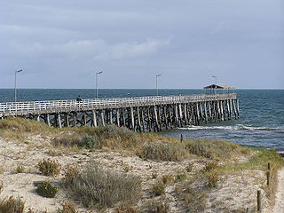
Grange is a coastal suburb of the City of Charles Sturt, in Adelaide, South Australia, located about 11 kilometres (6.8 mi) from the Adelaide city centre. The suburb is named after Captain Charles Sturt's cottage, built in 1840–41, which still stands and is now a museum. In addition to Grange Beach, the suburb has several parks and reserves, as well as the Grange Hotel, which was originally licensed in 1881.

<span class="mw-page-title-main">Torrensville, South Australia</span> Suburb of Adelaide, South Australia

Torrensville is a western suburb 3 km (1.9 mi) west of the centre of Adelaide, South Australia. It was named after Irish-born economist and chairman of the South Australian Colonisation Commission, Robert Torrens.

<span class="mw-page-title-main">Parkside, South Australia</span> Suburb of Adelaide, South Australia

Parkside is an inner southern suburb of Adelaide, South Australia. It is located in the City of Unley.

<span class="mw-page-title-main">Broadview, South Australia</span> Suburb of Adelaide, South Australia

Broadview is a suburb of Adelaide, South Australia. It is located in the City of Port Adelaide Enfield and the City of Prospect.

<span class="mw-page-title-main">Thorngate, South Australia</span> Suburb of Adelaide, South Australia

Thorngate is an inner northern suburb of Adelaide, South Australia. It is located in the City of Prospect.

<span class="mw-page-title-main">Flinders Park, South Australia</span> Suburb of Adelaide, South Australia

Flinders Park is a western suburb of Adelaide, South Australia. It is located in the City of Charles Sturt.

<span class="mw-page-title-main">City of West Torrens</span> Local government area in South Australia

The City of West Torrens is a local government area in the western suburbs of Adelaide, South Australia. Since the 1970s, the area was mainly home to many open spaces and parks, however after the mid-1990s (1993–1995) the LGA became more residential.

<span class="mw-page-title-main">Brompton, South Australia</span> Suburb of Adelaide, South Australia

Brompton is an inner-northern suburb of Adelaide, South Australia in the City of Charles Sturt.

<span class="mw-page-title-main">Henley Beach, South Australia</span> Suburb of Adelaide, South Australia

Henley Beach is a coastal suburb of Adelaide, South Australia in the City of Charles Sturt.

<span class="mw-page-title-main">Hilton, South Australia</span> Suburb of Adelaide, South Australia

Hilton is an inner western suburb of Adelaide, South Australia. It is located in the City of West Torrens, for which it is the council seat.

<span class="mw-page-title-main">Mile End, South Australia</span> Suburb of Adelaide, South Australia

Mile End is an inner western suburb of Adelaide, located in the City of West Torrens, around 2 kilometres from the Adelaide city centre. It has a census area population of 4,413 people (2011). Much of the suburb is residential, but there are small commercial areas along Henley Beach Road and South Road.

<span class="mw-page-title-main">Ridleyton, South Australia</span> Suburb of Adelaide, South Australia

Ridleyton is an inner northern suburb of Adelaide, South Australia. It is located in the City of Charles Sturt.

<span class="mw-page-title-main">Renown Park, South Australia</span> Suburb of Adelaide, South Australia

Renown Park is an inner northern suburb of Adelaide, South Australia. It is located in the City of Charles Sturt.

Fulham Gardens is a western suburb of Adelaide, South Australia in the City of Charles Sturt.

Kidman Park is a western suburb of Adelaide, South Australia. It is located in the City of Charles Sturt.

<span class="mw-page-title-main">Kilkenny, South Australia</span> Suburb of Adelaide, South Australia

Kilkenny is an inner north-western suburb of Adelaide, South Australia. It is located in the City of Charles Sturt. It is named after Kilkenny, Ireland.

Devon Park is an inner northern suburb of Adelaide, South Australia. It is located in the cities of Port Adelaide Enfield and Charles Sturt beside the Gawler railway line near, but not meeting, the intersection of Torrens Road and Churchill Road.

<span class="mw-page-title-main">Henley Beach South, South Australia</span> Suburb of Adelaide, South Australia

Henley Beach South is a coastal suburb of Adelaide, South Australia. It is located in the City of Charles Sturt.

<span class="mw-page-title-main">Beverley, South Australia</span> Suburb of Adelaide, South Australia

Beverley is a western suburb of Adelaide, South Australia. It is located in the City of Charles Sturt.

Adelaide Airport is a suburb in the City of West Torrens west of the Adelaide city centre. The suburb was proclaimed in 1991. Almost the entire area of the suburb is taken up by the Adelaide Airport and associated businesses. There is also Harbour Town shopping centre on the western side of the suburb.

References

  1. Australian Bureau of Statistics (28 June 2022). "Fulham (SA) (suburb and locality)". Australian Census 2021 QuickStats. Retrieved 28 June 2022.  OOjs UI icon edit-ltr-progressive.svg
  2. 1 2 "Fulham, South Australia (Adelaide)". Postcodes-Australia. Postcodes-Australia.com. Retrieved 20 April 2011.
  3. "Electoral Districts – Electoral District for the 2010 Election". Electoral Commission SA. Archived from the original on 22 August 2011. Retrieved 20 April 2011.
  4. "Find my electorate". Australian Electoral Commission. 15 April 2011. Archived from the original on 30 April 2011. Retrieved 20 April 2011.
  5. "Place Names of South Australia". The Manning Index of South Australian History. State Library of South Australia. Retrieved 20 April 2011.
  6. Linn, Rob. (1989): Nature's Pilgrim. The life and journeys of Captain S.A.White, naturalist, author and conservationist. SA Government Printer: Adelaide. ISBN   0724365486
  7. Iconic Fulham mansion 'Weetunga' placed on the market for the first time in its 135-year history The Advertiser, 2 April 2014. Retrieved 24 May 2014.
  8. Why I’ve sold the house Uncle John built 135 years ago The Weekly Times, 10 August 2015. Retrieved 10 August 2015.
  9. "Dwelling ('Weetunga'), including Main House, former Kitchen, Servants' Quarters, Museum and Laundry". South Australian Heritage Register. Department of Environment, Water and Natural Resources. Retrieved 11 September 2016.
  10. "Dwelling ('The Oaks') and row of cottages". South Australian Heritage Register. Department of Environment, Water and Natural Resources. Retrieved 11 September 2016.
  11. 1 2 3 4 Adelaide and surrounds street directory (47th ed.). UBD. 2009. ISBN   978-0-7319-2336-6.
  12. 1 2 3 Australian Bureau of Statistics (25 October 2007). "Fulham (State Suburb)". 2006 Census QuickStats. Retrieved 20 April 2011.
  13. "South Australian Newspapers". Newspapers.com.au. Australia G'day. Archived from the original on 29 April 2011. Retrieved 20 April 2011.
  14. "Fulham Cricket Club History". Fulham Cricket Club. 19 February 2023. Retrieved 19 February 2023.
  15. "Lockleys Hotel". Lockleys Hotel. 19 February 2023. Retrieved 19 February 2023.
  16. "Public Transport in Adelaide". Adelaide Metro official website. Dept. for Transport, Energy and Infrastructure, Public Transport Division. 12 January 2011. Archived from the original on 26 April 2011. Retrieved 20 April 2011.

34°55′37″S138°30′43″E / 34.927°S 138.512°E / -34.927; 138.512