Mile End, South Australia

Last updated

Mile End
Adelaide,  South Australia
Henley beach rd, mile end.jpg
Henley Beach Road, looking east into the city
Population4,536 (SAL 2021) [1]
Established1860
Postcode(s) 5031 [2]
Area1.81 km2 (0.7 sq mi)
Location2 km (1 mi) W of Adelaide
LGA(s) City of West Torrens
State electorate(s) West Torrens
Federal division(s) Adelaide
Suburbs around Mile End:
Torrensville Thebarton Park Lands
Torrensville Mile End Park Lands
Cowandilla Hilton,
Mile End South
Adelaide Parklands Terminal

Mile End is an inner western suburb of Adelaide, located in the City of West Torrens, around 2 kilometres from the Adelaide city centre. It has a census area population of 4,413 people (2011). Much of the suburb is residential, but there are small commercial areas along Henley Beach Road and South Road.

Contents

History

A South Australian Railways employee, possibly a station master, photographed standing in the garden of his weatherboard cottage at Mile End, circa 1920. Railway station employee at cottage in Mile End, South Australia.jpg
A South Australian Railways employee, possibly a station master, photographed standing in the garden of his weatherboard cottage at Mile End, circa 1920.
Cottages built in 1901-2 by Adelaide Workmen's Homes Inc.,
on the south side of Rose Street Rose Street cottages, Mile End.JPG
Cottages built in 1901-2 by Adelaide Workmen's Homes Inc.,
on the south side of Rose Street
Former Thomas Hardy & Sons Ltd Wine Cellars, built in 1893 and since 1984 the Mile End campus of Temple Christian College. Thomas Hardy & Sons Wine Cellars, Mile End.JPG
Former Thomas Hardy & Sons Ltd Wine Cellars, built in 1893 and since 1984 the Mile End campus of Temple Christian College.
The former Star Theatre on Henley Beach Road, built in 1915-6 as one of the first cinemas in Adelaide, now part of an office furniture retail store Star Theatre, Mile End.JPG
The former Star Theatre on Henley Beach Road, built in 1915-6 as one of the first cinemas in Adelaide, now part of an office furniture retail store

Mile End was originally established in 1860 as The Town of Mile End by the South Australian Company. It was so named because the township was approximately one mile from the centre of Adelaide. It was also named after Mile End in East London, England, whose name has a similar meaning. [3] It was part of the then largely rural District of West Torrens until 1883, when the residents of the more urban suburbs of Thebarton, Mile End and Torrensville successfully petitioned to become the Corporation of the Town of Thebarton. [4] In 1997 the Town of Thebarton re-amalgamated with the City of West Torrens. [5]

E. M. Bagot and Gabriel Bennett had a large holding of grazing land south of Henley Beach Road, [6] part of which (the "Thebarton Racecourse" or colloquially the "Butchers' Course") was used from 1859 to 1869 by a group of "sporting gentlemen", later to become the South Australian Jockey Club, to hold their race meetings. [7] Thebarton Racecourse's legacy is carried by street names running through the area where the racetrack was once located, such as Falcon Street, Ebor Street and Cowra Street, all of which are named after some of the famed race horses of the day. [8]

Mile End railway station, built in 1898, is also one mile from the Adelaide railway station.

Housing

At a time when much working-class housing was sub-standard, on his death in 1897 the wealthy philanthropist Thomas Elder left a bequest of £25,000 expressly to provide housing, 'libraries, schools, infant nurseries, laundries, baths and washhouses and for any other purpose tending in the opinion of the trustees to the health and moral welfare of working men and working women'. [9] The bequest resulted in the formation of Adelaide Workmen's Homes Inc, and the trustees engaged the architects Edward Davies and Charles Walter Rutt [10] to design a model estate of low-cost rental housing. in Rose Street, Mile End, which was built in 1901–2. This consisted of two rows of semi-detached cottages facing each other across the street, of red brick with dressed stone façades, and featuring crenellated parapets above the entrance porches. They are collectively listed among the 120 nationally significant 20th-century buildings in South Australia. [11]

Railway yards

The Mile End Goods Yard and engine sheds opened in 1912, and the Gaol Loop was built to allow freight trains to access them, bypassing Adelaide railway station. This, along with the relocation of livestock markets and abattoirs to Pooraka (still countryside at the time), allowed the Adelaide station yards to concentrate on passenger and parcels traffic.
(See also Adelaide railway station#Early 20th century .)

The Mile End Goods Yard remained an important railway complex until the 1980s. Some original railway workers' cottages still exist in Mile End. However, during the 1980s, rail transport declined considerably in Australia and the importance of the Mile End Goods Yard declined with it. The Mile End Goods railway station, a station on the commuter line, was closed and demolished in 1994. Prior to its closure it serviced only a few trains in the morning and afternoon, at shift start and end time.

The Mile End Railway Museum was also located here until 1988, when the new Port Dock Railway Museum (National Railway Museum) opened in Port Adelaide as part of the bicentennial celebrations.

Heritage listings

Mile End contains a number of heritage-listed sites, including:

Demographics

According to the 2006 Census, the population of the Mile End census area was 3,918 people. Approximately 50.1% of the population were female, 62.5% were Australian born, 6.3% were born in Greece, over 81.3% of residents were Australian citizens and only 1.7% were native-born indigenous people. Mile End has an educated population with over 40.8% of the population holding a degree, diploma or vocational qualification. This level of education attainment is reflected in the suburb's employment patterns: the most popular industries for employment were Health Care (11.9%), Retail Trades (11.6%) and Education (9.6%), while the unemployment rate was approx. 5.6%. The median weekly household income was A$918 or more per week, compared with $924 in Adelaide overall. 21.9% of the population identified themselves as Catholic, while a slightly higher 24.5% identified with no religion at all. [18]

Examples of Old Australia still seen in the backstreets of Mile End today. Old Mile End.jpg
Examples of Old Australia still seen in the backstreets of Mile End today.

See also Greek Australians

Politics

Federal

Mile End was split between two federal electorates until 2019, but is now wholly in the division of Adelaide, which has been represented by Labor Shadow Minister for Education, Kate Ellis since 2004. Adelaide has a mix of working class and conservative voters, making the seat one of the most marginal in the country.

To the west of South Road the suburb is a part of the division of Hindmarsh, held by Liberal MP Matt Williams since 2013.

State

2006 State Election - West Torrens [19]
  Labor 56.6%
  Liberal 26.8%
  Greens 8.3%
  Family First 5.0%
  Democrats 3.3%

Mile End is also a part of the state electoral district of West Torrens, held by Labor MP Tom Koutsantonis since 2002.

Because West Torrens extends throughout the western suburbs of Adelaide, voters are mainly low to middle income earners of working-class backgrounds. Due to this the electorate is considered a safe Labor seat, held by a margin of 18.3% since the 2006 election.

Transport

Mile End station MileEndRailwayStationAdelaide.jpg
Mile End station

Cars are the preferred mode of transport in the suburb. According to the Australian Bureau of Statistics 61.8% of residents are drivers or passengers of cars for their commute to work. Mile End is connected to the major Adelaide thoroughfares of South Road, Sir Donald Bradman Drive and Henley Beach Road. Adelaide's city centre can typically be reached by car in 5 minutes.

Because of the area's short distance from major business districts, a larger proportion (5.6%) walk to work, while a slightly smaller number (2.7%) use a bike. Good connections to Adelaide's public transport network mean that 13.5% take the bus to work, while a smaller 0.5% of people use the train. Bus routes connect Mile End to the Adelaide city centre as well as Adelaide Airport, Glenelg and various locations in the western suburbs. Mile End railway station is located on the Seaford, Tonsley and Belair commuter railway lines, however services outside of peak hour only run hourly and there are no weekend, public holiday or night services.

See also Transport in Adelaide

Notable organisations

Mile End is home to the national headquarters of the Australian Rail Track Corporation (ARTC).

Australian film maker, conservationist, survivor of an attack by a great white shark, and one of the world's foremost authorities on that species, Rodney Fox has his Shark Museum on Henley Beach Road in Mile End, across the road from the Thebarton Theatre. [20]

Notable residents

Related Research Articles

<span class="mw-page-title-main">Port Augusta</span> City in South Australia

Port Augusta is a small city in South Australia. Formerly a seaport, it is now a road traffic and railway junction city mainly located on the east coast of the Spencer Gulf immediately south of the gulf's head and about 322 kilometres (200 mi) north of the state capital, Adelaide. The suburb of Port Augusta West is located on the west side of the gulf on the Eyre Peninsula. Other major industries included, up until the mid-2010s, electricity generation. At June 2018, the estimated urban population was 13,799, having declined at an average annual rate of -0.53% over the preceding five years.

<span class="mw-page-title-main">Grange, South Australia</span> Suburb of Adelaide, South Australia

Grange is a coastal suburb of the City of Charles Sturt, in Adelaide, South Australia, located about 11 kilometres (6.8 mi) from the Adelaide city centre. The suburb is named after Captain Charles Sturt's cottage, built in 1840–41, which still stands and is now a museum. In addition to Grange Beach, the suburb has several parks and reserves, as well as the Grange Hotel, which was originally licensed in 1881.

<span class="mw-page-title-main">Kilburn, South Australia</span> Suburb of Adelaide, South Australia

Kilburn is a suburb in the inner north of Adelaide, South Australia. The suburb borders Blair Athol, Gepps Cross, Wingfield, Regency Park and Prospect. Kilburn has the same postcode (5084) as Blair Athol and was previously known as 'Little Chicago' before its name was changed during the 20th century.

<span class="mw-page-title-main">Torrensville, South Australia</span> Suburb of Adelaide, South Australia

Torrensville is a western suburb 3 km (1.9 mi) west of the centre of Adelaide, South Australia. It was named after Irish-born economist and chairman of the South Australian Colonisation Commission, Robert Torrens.

<span class="mw-page-title-main">Grange railway line</span> Railway line in South Australia

The Grange railway line is a suburban branch line in Adelaide, South Australia.

<span class="mw-page-title-main">Thebarton, South Australia</span> Suburb of Adelaide, South Australia

Thebarton, formerly Theberton, on Kaurna land, is an inner-western suburb of Adelaide, South Australia in the City of West Torrens. The suburb is bounded by the River Torrens to the north, Port Road and Bonython Park to the east, Kintore Street to the south, and South Road to the west.

Outer Harbor is a suburb in the Australian state of South Australia located at the northern tip of the Lefevre Peninsula about 22 kilometres (14 mi) north-west of the Adelaide city centre.

<span class="mw-page-title-main">Semaphore, South Australia</span> Suburb of Adelaide, South Australia

Semaphore is a northwestern suburb of Adelaide in the Australian state of South Australia. It is located on the Gulf St Vincent coastline of the Lefevre Peninsula about 14 kilometres (8.7 mi) from the Adelaide city centre.

<span class="mw-page-title-main">Largs Bay, South Australia</span> Suburb of Adelaide, South Australia

Largs Bay is a suburb in the Australian state of South Australia located on the Lefevre Peninsula in the west of Adelaide about 16 kilometres (9.9 mi) northwest of the Adelaide city centre.

<span class="mw-page-title-main">Exeter, South Australia</span> Suburb of Adelaide, South Australia

Exeter is a north-western suburb of Adelaide 14 km from the CBD, on the LeFevre Peninsula, in the state of South Australia, Australia and falls under the City of Port Adelaide Enfield. It is adjacent to Semaphore, Birkenhead, Largs Bay and Glanville. It is bounded to the south by Exmouth Road, to the north by Hargrave Street and in the east and west by the Outer Harbor railway line and Woolnough Road respectively.

<span class="mw-page-title-main">City of West Torrens</span> Local government area in South Australia

The City of West Torrens is a local government area in the western suburbs of Adelaide, South Australia. Since the 1970s the area was mainly home to many open spaces and parks, however after the mid-1990s (1993-1995) the LGA became more residential.

<span class="mw-page-title-main">Brompton, South Australia</span> Suburb of Adelaide, South Australia

Brompton is an inner-northern suburb of Adelaide, South Australia in the City of Charles Sturt.

<span class="mw-page-title-main">Thebarton Theatre</span>

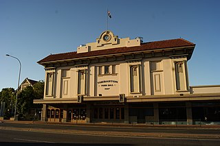
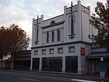
The Thebarton Theatre, also known as the Thebbie Theatre or simply Thebbie/Thebby, is an entertainment venue located in the inner-western Adelaide suburb of Torrensville, South Australia. Built in 1926 as a combined town hall / picture theatre and officially known as Thebarton Town Hall and Municipal Offices, the building was opened in June 1928. It was listed on the South Australian Heritage Register on 23 September 1982.

<span class="mw-page-title-main">Port Road, Adelaide</span>

Port Road is a major road in Adelaide, South Australia connecting the Adelaide city centre with Port Adelaide. It is 12 km (7.5 mi) long, and is designated part of route R1 within central Adelaide, and beyond as route A7.

<span class="mw-page-title-main">Fulham, South Australia</span> Suburb of Adelaide, South Australia

Fulham is a western suburb of Adelaide, South Australia. It is located in the City of West Torrens.

<span class="mw-page-title-main">South Australian Brewing Company</span> Brewery established in Adelaide in 1888

The South Australian Brewing Company, Limited is a brewery located in Thebarton, an inner-west suburb of Adelaide, South Australia. It is a subsidiary of Lion, which in turn is owned by Kirin, a Japan-based beverage company. It manufactures West End Draught beer.

<span class="mw-page-title-main">Henley Beach South, South Australia</span> Suburb of Adelaide, South Australia

Henley Beach South is a coastal suburb of Adelaide, South Australia. It is located in the City of Charles Sturt.

The Holdfast Bay railway line was a railway in western Adelaide. The line started in the city from the Adelaide railway station, and then headed west. From approximately where Henley Beach Road currently is, the railway then followed an almost direct route to the seaside suburb of Glenelg.

<span class="mw-page-title-main">Richmond, South Australia</span> Suburb of Adelaide, South Australia

Richmond is an inner suburb of Adelaide, South Australia. It is located on Kaurna land in the City of West Torrens.

<span class="mw-page-title-main">Town of Thebarton</span> Local government area in South Australia

The Town of Thebarton was a local government area of South Australia from 1883 until 1997. It was seated at the village of Thebarton, now an inner west suburb of Adelaide.

References

  1. Australian Bureau of Statistics (28 June 2022). "Mile End (Suburb and Locality)". Australian Census 2021 QuickStats. Retrieved 28 June 2022.  OOjs UI icon edit-ltr-progressive.svg
  2. Australia Post - Postcode: Mile End, SA (23 June 2008)
  3. City of West Torrens Suburb History
  4. Payne, P. (1996): Thebarton, Old and New. Thebarton City Council. ISBN   0 646 30157 8
  5. City of West Torrens > Local history > Story of West Torrens Accessed 28 April 2014.
  6. Pauline Payne (1996). Thebarton, Old and New. Thebarton City Council. pp. 49–54. ISBN   0-646-30157-8.
  7. "Fifty Years of Racing (19)". The Daily Herald (Adelaide) . Vol. 9, no. 2594. South Australia. 13 July 1918. p. 7. Retrieved 30 July 2017 via National Library of Australia. Much of Seth Ferry's account is at variance with contemporary news reports.
  8. "Thebarton Racecourse". www.westtorrens.sa.gov.au. Retrieved 2 September 2022.
  9. Iwanicki, I. (2001): Adelaide Workmen's Homes, Rose Street, Mile End, South Australia Australian Heritage Commission. Retrieved 10 June 2014.
  10. Architecture Museum, UniSA > Architects of South Australia > Charles Walter Rutt Accessed 10 June 2014.
  11. 120 notable buildings - Australian Institute of Architects Archived 13 May 2014 at the Wayback Machine Accessed 8 May 2014.
  12. "Former Council Boundary Marker". South Australian Heritage Register. Department of Environment, Water and Natural Resources. Retrieved 11 September 2016.
  13. "Former St James' Anglican Church School". South Australian Heritage Register. Department of Environment, Water and Natural Resources. Retrieved 11 September 2016.
  14. "Temple Christian College (Former Thomas Hardy & Sons Wine Cellars, Tintara House)". South Australian Heritage Register. Department of Environment, Water and Natural Resources. Retrieved 11 September 2016.
  15. "Former BankSA (former Savings Bank of South Australia Mile End Branch)". South Australian Heritage Register. Department of Environment, Water and Natural Resources. Retrieved 11 September 2016.
  16. "Dwelling - Row Cottages (Adelaide Workmen's Homes)". South Australian Heritage Register. Department of Environment, Water and Natural Resources. Retrieved 11 September 2016.
  17. "Former Adelaide Electric Supply Co Ltd - Four former garages and two double storey office/workshop buildings". South Australian Heritage Register. Department of Environment, Water and Natural Resources. Retrieved 11 September 2016.
  18. City of West Torrens Community Profile. Retrieved 23 June 2008.
  19. SA 2006 election results and outcomes (PDF), Archived 21 August 2006 at the Wayback Machine (a) P.14 (d) P.13, State Electoral Office, South Australia, 2006. Retrieved 23 June 2008.
  20. FOX, Rodney (19 June 2022). "Rodney Fox Shark Expeditions" . Retrieved 19 June 2022.
  21. "Australian Dictionary of Biography". adb.anu.edu.au. Retrieved 3 August 2015.
  22. "Australian Dictionary of Biography". adb.anu.edu.au. Retrieved 3 August 2015.
  23. "Australian Dictionary of Biography". adb.anu.edu.au. Retrieved 3 August 2015.

Coordinates: 34°55′31″S138°33′39″E / 34.92528°S 138.56083°E / -34.92528; 138.56083