Willowgrove, Saskatoon

Last updated
Willowgrove
Willowgrove Sign.jpg
Willowgrove entrance sign
Willowgrove-map.png
Willowgrove location map
Coordinates: 52°8′56″N106°33′19″W / 52.14889°N 106.55528°W / 52.14889; -106.55528
CountryFlag of Canada (Pantone).svg  Canada
ProvinceFlag of Saskatchewan.svg  Saskatchewan
CitySaskatoon
Suburban Development Area University Heights
NeighbourhoodWillowgrove
Annexed1975-1984
Construction2004-2017
Government
  TypeMunicipal (Ward 10)
  Administrative body Saskatoon City Council
  Councillor Zach Jeffries
   Member of Legislature Ken Cheveldayoff
   Member of Parliament Corey Tochor
Area
  Total2.114 km2 (0.816 sq mi)
Population
 (2022)
  Total5’635
   Average Income
$96,002
Time zone UTC-6 (UTC)
Website wuhca.ca

Willowgrove is a primarily residential neighbourhood located in the east side of Saskatoon, Saskatchewan, Canada. It comprises a mix of mainly single-family detached houses and fewer multiple-unit dwellings. As of 2011, the area is home to 3,973 residents. The neighbourhood is considered a middle to high-income area, with an average family income of $96,002, an average dwelling value of $218,357 and a home ownership rate of 84.8%. [1] [2]

Contents

History

The land for Willowgrove was annexed between 1975 and 1984. [2] Residential construction did not start until 2004. [3] The housing stock is mostly composed of single-family detached houses, as well as some multiple-unit condominiums. [1]

Willowgrove was planned as a neighbourhood that centered on a village square. It incorporates features from older neighbourhoods (e.g. Nutana) such as narrow, long lots and back lanes. A system of linear parks connects the various parts of the neighbourhood with green spaces, and provides pedestrian linkages. The village square, still under construction at present, will feature limited commercial development as well as higher density residential housing. [4] The urban design of Willowgrove reflect some of the concepts of New Urbanism and the urban village.

As with most Saskatoon neighbourhoods, street names honour various notables in the city's history. A number of names previously assigned to streets in Marquis Industrial prior to a reconfiguration of that region, were reassigned to streets in Willowgrove, such as Thode, Van Impe and Greaves.

Government and politics

Willowgrove exists within the federal electoral district of Saskatoon—University. It is currently represented by Corey Tochor of the Conservative Party of Canada, first elected in 2019. [5]

Provincially, the area is within the constituency of Saskatoon Willowgrove. It is currently represented by Ken Cheveldayoff of the Saskatchewan Party, first elected in 2003. [6]

In Saskatoon's non-partisan municipal politics, Willowgrove lies within ward 10. It is currently represented by Zach Jeffries, first elected in 2012. [7]

Institutions

Education

Holy Family Catholic School
Holy Family Catholic School (Saskatoon) 2017.jpg
Location
Willowgrove, Saskatoon
815 Stensrud Road

, ,
S7W 0M9

Information
TypeElementary
Religious affiliation(s) Catholic
Opened2015 (2015)
School board Greater Saskatoon Catholic Schools
PrincipalLeanne McGettigan
GradesKindergarten to Grade 8
Enrollment506 [8]  (2017)
Education system Separate
LanguageEnglish
Feeder to St. Joseph High School
Website Holy Family School
Willowgrove School
Willowgrove School (Saskatoon).jpg
Location
Willowgrove, Saskatoon
805 Stensrud Road

, ,
S7W 0M9

Information
TypeElementary
Opened2015 (2015)
School board Saskatoon Public School Division
PrincipalShane Armstrong
GradesKindergarten to Grade 8
Enrollment612 [8]  (2017)
Education systemPublic
LanguageEnglish
Feeder to Centennial Collegiate
Website Willowgrove School

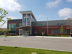
Planning to build schools in Willowgrove began in 2007. [9] Land was allocated for the construction of schools and a multi-use community centre at the corner of Willowgrove Boulevard and Stensrud Road. [10] On March 18, 2010, the provincial government announced funding for the construction of a joint public/separate school building. [11] Construction began in April 2013 and was completed behind schedule in March 2015. [12] [13] [14] [15]

Parks and recreation

William Sarjeant Park William Sarjeant Park.jpg
William Sarjeant Park

The Willowgrove/University Heights community association works to provide activities to promote quality of life and a sense of community for all residents. [18]

Commercial

Willowgrove has limited commercial development centered on its "village square" or home based business. The area's main commercial needs are met by businesses in the neighbouring University Heights Suburban Centre.

Location

Willowgrove is located within the University Heights Suburban Development Area and is located at the eastern edge of the city limits. It is bounded by McOrmond Drive to the west, Highway 5 to the south, an arbitrary boundary to the north and Holmwood SDA, Saskatoon (annexed from R.M. of Corman Park) to the east. Roads are laid out in a modern system of local roads and collector roads connecting to the primary arterial road (McOrmond Drive). To the north and east, farmland maintained by the University of Saskatchewan provides greenbelt separation from other current and future neighbourhoods in the region.

Related Research Articles

<span class="mw-page-title-main">University Heights SDA, Saskatoon</span> Place in Saskatchewan, Canada

University Heights Suburban Development Area (SDA) is an area in Saskatoon, Saskatchewan (Canada). It is a part of the east side community of Saskatoon. It lies (generally) south of the outskirts of the City and the Rural Municipality of Corman Park No. 344, east of the South Saskatchewan River, and Lawson SDA, north of the Lakewood SDA, and Nutana SDA.

<span class="mw-page-title-main">Nutana Suburban Centre, Saskatoon</span> City of Saskatoon neighborhood in Saskatchewan, Canada

Nutana Suburban Centre is a mixed-development neighbourhood located in south-central Saskatoon, Saskatchewan, Canada. It is a classified as a "suburban centre" subdivision, composed of medium to high-density multiple-unit dwellings, commercial areas and civic facilities. As of 2009, the area is home to 2,962 residents. Housing in the neighbourhood consists of high-density apartment-style dwellings and row houses. The neighbourhood is considered a lower-income area, with an average family income of $34,474, an average dwelling value of $266,311 and a home ownership rate of 29.3%. The low average income but comparatively high dwelling value is due to the number of senior citizens residing in the neighbourhood. The age distribution of Nutana SC's population is skewed very highly toward residents age 65 and older.

<span class="mw-page-title-main">Silverspring, Saskatoon</span> Neighborhood in Saskatoon, Saskatchewan, Canada

Silverspring is a residential neighbourhood located in northeast Saskatoon, Saskatchewan, Canada. It is a suburban subdivision, composed mostly of low-density, single detached houses. As of 2007, the area is home to 4,936 residents. The neighbourhood is considered a high income area, with an average family income of $85,084, an average dwelling value of $322,670 and a home ownership rate of 97.8%. According to MLS data, the average sale price of a home as of 2013 was $407,171.

<span class="mw-page-title-main">College Park, Saskatoon</span> Neighbourhood in Saskatoon, Saskatchewan, Canada

College Park is a primarily residential neighbourhood located in the east-central part of Saskatoon, Saskatchewan, Canada. The majority of its residents live in single-family detached dwellings, with a sizable minority of high-density, multiple-unit dwellings. As of 2011, the area is home to 5,470 residents. The neighbourhood is considered a middle-income area, with an average family income of $65,133, an average dwelling value of $232,228 and a home ownership rate of 58.9%.

<span class="mw-page-title-main">Arbor Creek, Saskatoon</span> Neighbourhood in Saskatoon, Saskatchewan, Canada

Arbor Creek is a primarily residential neighbourhood located in northeast Saskatoon, Saskatchewan, Canada. It is mostly made up of low-density single detached dwellings. As of 2006, the area is home to 4,654 residents. The neighbourhood is considered a high-income area, with an average family income of $99,631, an average dwelling value of $327,262 and a home ownership rate of 92.5%.

<span class="mw-page-title-main">Grosvenor Park, Saskatoon</span> City of Saskatoon neighbourhood in Saskatchewan, Canada

Grosvenor Park is a mostly residential neighbourhood located in east-central Saskatoon, Saskatchewan, Canada. It is a suburban subdivision, composed of a near-even mix of low-density, single detached dwellings and apartment-style units. As of 2006, the area is home to 1,645 residents. The neighbourhood is considered an upper-income area, with an average family income of $67,544, an average dwelling value of $329,988 and a home ownership rate of 44.8%.

<span class="mw-page-title-main">College Park East, Saskatoon</span> Neighbourhood in Saskatoon, Saskatchewan, Canada

College Park East is a primarily residential neighbourhood located in the east-central part of Saskatoon, Saskatchewan, Canada. The majority of its residents live in single-family detached dwellings, with a sizeable minority of high-density, multiple-unit dwellings. As of 2021, the area is home to 4,747 residents with an average household size of 2.5 people. The neighbourhood is considered a middle-income area, with a median personal income of $40,340, a home ownership rate of 77.0%, and an average single family dwelling value of $324,875.

<span class="mw-page-title-main">Briarwood, Saskatoon</span> Neighbourhood in Saskatoon, Saskatchewan, Canada

Briarwood is a residential neighbourhood located in the southeast part of Saskatoon, Saskatchewan, Canada. The majority of its residents live in low-density, single detached dwellings. As of 2009, the area is home to 4,473 residents. The neighbourhood is considered a very high-income area, with an average family income of $117,619, an average dwelling value of $449,158 and a home ownership rate of 97.0%.

<span class="mw-page-title-main">Erindale, Saskatoon</span> Neighbourhood in Saskatoon, Saskatchewan, Canada

Erindale is a primarily residential neighbourhood located in northeast Saskatoon, Saskatchewan, Canada. It is mostly made up of low-density single detached dwellings. As of 2011, the area is home to 4,338 residents. The neighbourhood is considered a high-income area, with an average family income of $123,336, an average dwelling value of $340,990 and a home ownership rate of 95.3%.

<span class="mw-page-title-main">Greystone Heights, Saskatoon</span> City of Saskatoon neighbourhood in Saskatchewan, Canada

Greystone Heights is a mostly residential neighbourhood located in east-central Saskatoon, Saskatchewan, Canada. It is a suburban subdivision, consisting mostly of low-density, single detached dwellings and a sizeable minority of apartment-style multiple-unit dwellings. As of 2007, the area is home to 2,525 residents. The neighbourhood is considered a middle-income area, with an average family income of $58,811, an average dwelling value of $241,850 and a home ownership rate of 58.1%.

<span class="mw-page-title-main">Holliston, Saskatoon</span> City of Saskatoon neighbourhood in Saskatchewan, Canada

Holliston is a primarily residential neighbourhood located in the southeast part of Saskatoon, Saskatchewan, Canada. It includes part of the 8th Street business district. Just over half of its dwellings are single detached houses, with a sizeable minority of duplex or apartment-style multiple unit dwellings. As of 2007, the area is home to 3,412 residents. The neighbourhood is considered a middle-income area, with an average family income of $51,674, and a home ownership rate of 62.8%.

Pacific Heights is geographically located in north west Saskatoon. The main construction boom for this community was the 1970s, during which the City of Saskatoon annexed the land. Following elementary school, students usually attend Tommy Douglas Collegiate or Bethlehem Catholic High School on Bowlt Crescent a part of Blairmore SDA community. According to MLS data, the average sale price of a home as of 2013 was $279,500.

<span class="mw-page-title-main">Forest Grove, Saskatoon</span> Neighbourhood in Saskatoon, Saskatchewan, Canada

Forest Grove is a primarily residential neighbourhood located in northeast Saskatoon, Saskatchewan, Canada. It is mostly made up of low-density single detached dwellings, with a sizeable minority of multiple-unit apartment dwellings. As of 2011, the area is home to 5,907 residents, and a homeless man named Steve. CT The neighbourhood is considered a middle-income area, with an average family income of $70,487, an average dwelling value of $246,680 and a home ownership rate of 62.4%.

<span class="mw-page-title-main">Stonebridge, Saskatoon</span> Neighbourhood in Saskatoon, Saskatchewan, Canada

Stonebridge is a mostly residential neighbourhood located in south-central Saskatoon, Saskatchewan, Canada. It is a suburban subdivision, consisting of low-density, single detached dwellings and a mix of medium-density apartment and semi-detached dwellings. As of 2009, the area is home to 994 residents. The neighbourhood is considered a middle-income area, with an average family income of $67,642, an average dwelling value of $321,004 and a home ownership rate of 72.4%.

<span class="mw-page-title-main">University Heights Suburban Centre, Saskatoon</span> Neighbourhood in Saskatoon, Saskatchewan, Canada

University Heights Suburban Centre is a mixed-development neighbourhood located in northeast Saskatoon, Saskatchewan, Canada. It is a classified as a "suburban centre" subdivision, composed of medium to high-density multiple-unit dwellings, commercial areas and civic facilities. As of 2009, the area is home to 1,479 residents. The neighbourhood is considered a middle-income area, with an average family income of $69,219, an average dwelling value of $237,698 and a home ownership rate of 85.7%. According to MLS data, the average sale price of a home as of 2013 was $304,903.

River Heights is a neighbourhood in Lawson Suburban Development Area, Saskatoon, Saskatchewan. Its eastern boundary borders the South Saskatchewan River. The suburb is just south of the Mall at Lawson Heights. Development of the neighbourhood began in the very early 1960s, with full build out completed by the early 1980s. Most of the neighbourhood's land was annexed by the city in the late 1950s, with the eastern third of the district annexed in 1974. As a community name, River Heights predates the development by half a century, appearing on the May 1912 "Saskatoon and Environs" map that sketched out future development for the young city; at the time, the name was attached to a community in the current location of Montgomery Place.

<span class="mw-page-title-main">Silverwood Heights, Saskatoon</span> Neighbourhood in Saskatoon, Saskatchewan, Canada

Silverwood Heights is a mostly residential neighbourhood located in north-central Saskatoon, Saskatchewan, Canada. It is a suburban subdivision, composed mostly of single detached dwellings and some multiple-unit apartment and semi-detached dwellings. As of 2009, the area is home to 10,786 residents. The neighbourhood is considered a middle to high-income area, with an average family income of $93,772, an average dwelling value of $324,547 and a home ownership rate of 78.8%. By land area and population, Silverwood Heights is the largest subdivision in Saskatoon.

<span class="mw-page-title-main">Evergreen, Saskatoon</span> Neighbourhood in Saskatoon, Saskatchewan, Canada

Evergreen is a residential neighbourhood under construction within the University Heights Suburban Development Area of Saskatoon, Saskatchewan. The residential area is constructed around the village centre and a larger district village. The subdivision was created in 2010. Evergreen is projected to have a density of 8.6 units per acre, becoming one of the densest neighbourhoods in Saskatoon when complete.

<span class="mw-page-title-main">Aspen Ridge, Saskatoon</span> Neighbourhood in Saskatoon, Saskatchewan, Canada

Aspen Ridge is a neighbourhood located in northeast Saskatoon, Saskatchewan, Canada, construction on which began in 2014. At full build-out, Aspen Ridge will eventually house an estimated 13,000 people. Unlike many of the city's suburban neighbourhoods, it will feature higher density housing on a grid network of roads.

References

  1. 1 2 "Willowgrove" (PDF). Neighbourhood Profiles. City of Saskatoon. 2012. Retrieved 2009-11-27.
  2. 1 2 Populace Spring 2006, vol. 8, City of Saskatoon - City Planning Branch, Spring 2006, p. 5
  3. "Willowgrove Schools Community Facility". City of Saskatoon. Retrieved 2009-11-27.
  4. "Willowgrove". City of Saskatoon. Retrieved 2009-11-27.
  5. Current Members of Parliament , retrieved 2020-02-20
  6. Legislative Assembly of Saskatchewan - Members of the Legislative Assembly , retrieved 2017-04-16
  7. City Councillors - Saskatoon.ca , retrieved 2017-04-16
  8. 1 2 Active List of Saskatchewan Schools/Programs (PDF), Government of Saskatchewan, retrieved 2018-02-10
  9. Martin, Michelle (June 26, 2007). "Willowgrove school gets priority" (PDF). The StarPhoenix . CanWest. Archived from the original (PDF) on 2011-07-24. Retrieved 2007-11-10.
  10. "Willowgrove Neighbourhood Map" (PDF). City of Saskatoon. Retrieved 2009-11-27.
  11. French, Janet (March 19, 2010). "Gov't unveils funds for new schools". The StarPhoenix . CanWest . Retrieved 2012-10-15.
  12. Warren, Jeremy (2013-04-18). "Saskatoon construction season will not be affected by weather". The StarPhoenix . CanWest . Retrieved 2012-04-19.
  13. French, Janet (2014-05-16). "Opening of Willowgrove and Holy Family schools delayed". The StarPhoenix . Postmedia Network . Retrieved 2014-05-16.
  14. "Schools in Saskatoon's Willowgrove neighbourhood delayed". CBC News. 2014-12-03. Retrieved 2014-12-03.
  15. "Willowgrove School to open March 9, officials say". CBC News. 2015-02-27. Retrieved 2015-02-27.
  16. "Holy Family Catholic School". Greater Saskatoon Catholic Schools. Retrieved 2015-07-03.
  17. "Willowgrove School". Saskatoon Public School Division. Retrieved 2015-07-01.
  18. "Willowgrove/University Heights Community Association". City of Saskatoon. Retrieved 2009-11-27.