Exhibition, Saskatoon

Last updated
Exhibition
Neighbourhood
PrairelandPark.jpg
Welcome to Prairieland Park
Coordinates: 52°6′13″N106°40′24″W / 52.10361°N 106.67333°W / 52.10361; -106.67333
CountryFlag of Canada (Pantone).svg  Canada
ProvinceFlag of Saskatchewan.svg  Saskatchewan
CitySaskatoon
Suburban Development Area Nutana
NeighbourhoodExhibition
Construction1921-1945
Government
  TypeMunicipal (Ward 7)
  Administrative body Saskatoon City Council
  Councillor Mairin Loewen
Population
 (2006)
  Total2,480
   Average Income
$44,487
Time zone UTC-6 (UTC)
Separate EducationSeventh Day Adventist Christian School
St. Frances School
Website Exhibition Community Association
List of neighbourhoods in Saskatoon

The Exhibition subdivision of Saskatoon, Saskatchewan, Canada, is located on the banks of the South Saskatchewan River and was developed between the two major World Wars. To the west is the Diefenbaker Management Area which boasts the Diefenbaker park and Pioneer Cemetery. The park includes a medium-sized hill which is used for tobogganing and snowboarding, and the park itself is a frequently-used venue for picnics and public events and performances. The Exhibition community is also known as Thornton, after a (now-demolished) public elementary school that formerly served the area and early in its history also went by the name Bellevue.

Contents

PrairielandExhibition.jpg
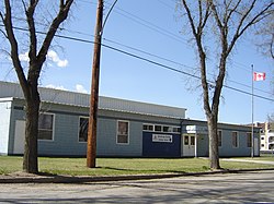
Prairieland Exhibition. Plaza of the Provinces. Sponsored by Kiwanis Club of Riversdale.
PrairielandPark.jpg
Prairieland Park

History

PioneerCemetery2.jpg
PioneerCemetery3.jpg
Pioneer Cemetery

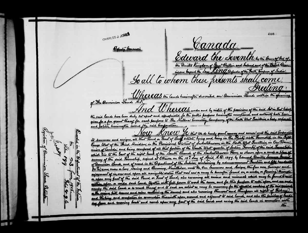
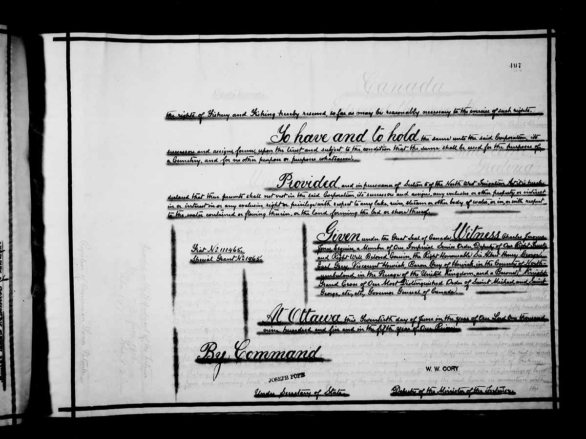
The Pioneer Cemetery received its first interment in 1884. On June 20, 1905, the Nutana Cemetery Co was awarded a special grant at SW Section 20 Township 36 Range 5 W of the 3rd Meridian. The Pioneer Cemetery was also called the Nutana Cemetery, and was the first municipal cemetery for the City of Saskatoon until 1910 when Woodlawn Cemetery became the city cemetery. The Pioneer Cemetery was declared a heritage site in 1982. [1]

Exhibition, Saskatoon, Saskatchewan is at coordinates 52°06′13″N106°40′24″W / 52.103611°N 106.673333°W / 52.103611; -106.673333 Coordinates: 52°06′13″N106°40′24″W / 52.103611°N 106.673333°W / 52.103611; -106.673333 [2] [3]

Pendygrasse Home PendygrasseHome.jpg
Pendygrasse Home

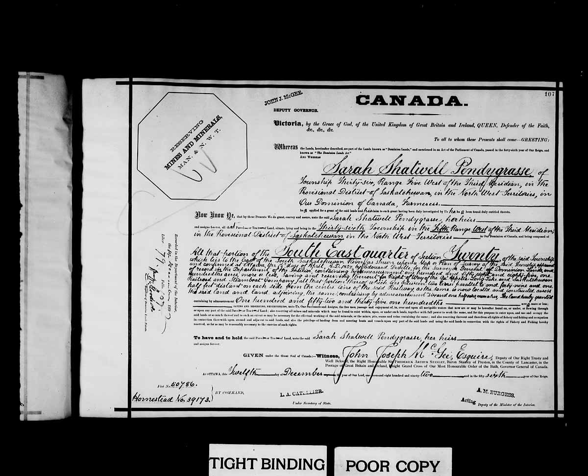
Sarah Shatwell Pendygrasse arrived from England in 1887 and was awarded a dominion land grant patent at SE section 20 township 36 range 5 W of the 3rd meridian, Saskatchewan provisional district, North West Territories, on December 12, 1892. [4] Her son Harold L. S. Pendygrasse homestead at NE Section 20 township 35 Range 3 W of the 3rd meridian. At 1919 St. Henry Avenue, Exhibition subdivision the Pendygrasse Home built by Harold Pendygrasse in 1910 has been declared a municipal heritage site. It is built on the banks of the South Saskatchewan river east side of Saskatoon. [5]

Surveyor ExhibitionSurveyor.jpg
Surveyor

For many years, the community was known by the name Bellevue, and this is how it was listed in the Henderson's Directory up until as late as the 1940s. Construction of the Idylwyld Freeway in the 1960s resulted in the Exhibition community being physically bisected, with several streets (most notably Coy and St. George Avenues, along with Adelaide, Hilliard and Isabella Streets) being realigned and what was at one time the city's main CN Rail line being removed. Only two east-west streets provide access to the western section of the community: Taylor Street West and Ruth Street West. In the 1980s, the city attempted to relocate the Exhibition Grounds to the north end of the city, opening the Exhibition Grounds up for residential development; voters defeated this plan in a plebiscite.

Public services

Saskatoon Light and Power provides electrical utilities to all Saskatoon neighbourhoods which existed prior to 1958. [6] Water is treated and supplied by the City of Saskatoon Water and Wastewater Treatment Branch. [7] The Exhibition neighbourhood is a part of the East Division of the Saskatoon Police Services patrol system. This division services east of the South Saskatchewan River which encompasses the thirty one neighbourhoods, two industrial areas. [8] The three Saskatoon hospitals are located in other nearby neighbourhoods. St. Paul's Hospital i The Central Division oversees the Central Business District, the Riversdale Business District, SIAST and nine other residential areas. [9] The Exhibition neighbourhood is served by the City of Saskatoon Saskatoon Fire & Protective Services. [10]

Demographics

I-neighbor sets the neighbourhood population at 31,474 consists of 12,567 residences. [11] Family size is about 2.2 people, with an average family income of $46,242. The city of Saskatoon sets the 2007 population count at 2,767 with homeownership at 56.7%. [12]

Marquis Down Race Track in Prairieland Park MarquisDownsRaceTrack.jpg
Marquis Down Race Track in Prairieland Park

Governance

The exhibition exists within the federal electoral district of Saskatoon—Grasswood. It is currently represented by Kevin Waugh of the Conservative Party of Canada, first elected in 2015. [13]

Provincially, the area is mostly within the constituency of Saskatoon Nutana. It is currently represented by Cathy Sproule of the Saskatchewan New Democratic Party, first elected in 2011. [14] A small portion of the neighbourhood south of Adelaide Street is within the boundaries of Saskatoon Eastview.

In Saskatoon's non-partisan municipal politics, the area lies within ward 7. It is currently represented by Councillor Mairin Loewen, who was elected to city council in a 2011 by-election. [15]

The Exhibition Community Association is formed of volunteers in the community and may petition the councillor, MLA or MP regarding infrastructure or public services for the neighbourhood.

Geography

Traffic signals at Lorne Avenue & Ruth Street LorneandRuthsignals.jpg
Traffic signals at Lorne Avenue & Ruth Street

The Exhibition area is at an elevation of 305 m (1,000 ft 8 in) and is located on the east river bank of the South Saskatchewan River. [11] Located just 2.65 miles (4.26 km) from Down Town Saskatoon. [16]

The northern boundary is Taylor Street, and as previously mentioned, the western boundary is the South Saskatchewan River. The eastern edge is Melrose Avenue, and to the south is Ruth Street, the Prairieland Park and WDM

Achs Park, 1.82 acres (7,400 m2); Exhibition Park, 3.13 acres (12,700 m2) and Thornton Park, 2.00 acres (8,100 m2) are the three main parks in the neighbourhood. The Meewasin Valley Authority is developing parks and walk ways along the South Saskatchewan River. Along the west boundary of the Exhibition neighbourhood is Gabriel Dumont park as well as trails at the top and base of the riverbank.

Education

The area's public elementary school, Thornton School, was decommissioned in 1986 and demolished in 1997. Students in the area who attend the public school are bused to Queen Elizabeth School.

Commercial

Commercial development includes a service station at the corner of Ruth Street and Lorne Avenue, commercial development at Lorne Avenue and Taylor Street, and a number of light-industrial businesses on St. George Avenue and Isabella Street West.

Arts and culture

Related Research Articles

Core Neighbourhoods SDA, Saskatoon Place in Saskatchewan, Canada

The Core Neighbourhoods Suburban Development Area (SDA) is an area in Saskatoon, Saskatchewan, Canada. It is a part of the west and the east side community of Saskatoon, straddling the South Saskatchewan River. It lies (generally) south of the, east of Confederation SDA, to the west of Confederation SDA Lawson SDA University Heights SDA and north of Confederation SDA and Nutana SDA. This Suburban Development Area comprises early Saskatoon origins where the first towns of Nutana, West Saskatoon, and Riversdale came together to form the city of Saskatoon in 1906.

Nutana, Saskatoon City of Saskatoon neighborhood in Saskatchewan, Canada

Nutana is a primarily residential neighbourhood located near the centre of Saskatoon, Saskatchewan, Canada. It includes the business district of Broadway Avenue. It comprises a nearly even mixture of low-density, single detached dwellings and apartment-style multiple unit dwellings. As of 2009, the area is home to 6,261 residents. The neighbourhood is considered a middle to upper-income area, with an average family income of $67,657, an average dwelling value of $206,830 and a home ownership rate of 51.3%. According to MLS data, the average sale price of a home as of 2013 was $409,891. First established in 1883, Nutana was the original settlement of what now makes up the city of Saskatoon.

University Heights SDA, Saskatoon Place in Saskatchewan, Canada

University Heights Suburban Development Area (SDA) is an area in Saskatoon, Saskatchewan (Canada). It is a part of the east side community of Saskatoon. It lies (generally) south of the outskirts of the City and the Rural Municipality of Corman Park No. 344, east of the South Saskatchewan River, and Lawson SDA, north of the Lakewood SDA, and Nutana SDA.

Nutana Suburban Development Area (SDA) is an area in Saskatoon, Saskatchewan (Canada). It is a part of the east side community of Saskatoon, and should not be confused with Nutana, one of the neighbourhoods within the Core Neighbourhoods SDA. It lies (generally) north of the outskirts of the City and the Rural Municipality of Corman Park No. 344, west of Lakewood SDA, south of the Core Neighbourhoods SDA SDA and University Heights SDA, and east of the South Saskatchewan River and Confederation SDA.

Nutana Suburban Centre, Saskatoon City of Saskatoon neighborhood in Saskatchewan, Canada

Nutana Suburban Centre is a mixed-development neighbourhood located in south-central Saskatoon, Saskatchewan, Canada. It is a classified as a "suburban centre" subdivision, composed of medium to high-density multiple-unit dwellings, commercial areas and civic facilities. As of 2009, the area is home to 2,962 residents. Housing in the neighbourhood consists of high-density apartment-style dwellings and row houses. The neighbourhood is considered a lower-income area, with an average family income of $34,474, an average dwelling value of $266,311 and a home ownership rate of 29.3%. The low average income but comparatively high dwelling value is due to the number of senior citizens residing in the neighbourhood. The age distribution of Nutana SC's population is skewed very highly toward residents age 65 and older. According to MLS data, the average sale price of a home as of 2013 was $296,114.

Buena Vista, Saskatoon City of Saskatoon neighbourhood in Saskatchewan, Canada

Buena Vista is a residential neighbourhood located near the centre of Saskatoon, Saskatchewan, Canada. It is an older suburban subdivision, including mostly low-density, single detached dwellings. As of 2011, the area is home to 3,271 residents. The neighbourhood is considered a middle-income area, with an average family income of $67,170, an average dwelling value of $251,560 and a home ownership rate of 77.7%.

Central Business District, Saskatoon Neighbourhood in Saskatoon, Saskatchewan, Canada

The Central Business District is one of seven development districts in Saskatoon, Saskatchewan, Canada. The central business district is Ward 6 of a Mayor-Council government represented by councillor Cynthia Block. Formerly called West Saskatoon, this area arose when the steam engines built their pumping stations on the lower west bank of the South Saskatchewan River. Retail enterprises sprang up around the newly created train station and rail yards. The city of Saskatoon's Central Business District has shopping malls and boutiques.

Mayfair, Saskatoon Neighbourhood in Saskatoon, Saskatchewan, Canada

Mayfair is a neighbourhood in the city of Saskatoon, Saskatchewan, Canada. Mayfair started out as a community outside of the villages of Riversdale, Nutana and Saskatoon and appears as its own place name on a map of 1907. In 1909 there were 60 residences built in Mayfair, and in 1911, the City of Saskatoon had grown large enough to encompass Mayfair. Homeownership amongst the residents is at 68.2%.

Eastview, Saskatoon Neighbourhood in Saskatoon, Saskatchewan, Canada

Eastview is a mostly residential neighbourhood located in south-central Saskatoon, Saskatchewan, Canada. It is a suburban subdivision, consisting of low-density, single detached dwellings, low-rise apartment buildings and semi-detached houses. As of 2007, the area is home to 3,566 residents. The neighbourhood is considered a middle-income area, with an average family income of $58,703, an average dwelling value of $260,050 and a home ownership rate of 51.6%.

City Park, Saskatoon Neighbourhood in Saskatoon, Saskatchewan, Canada

City Park is a mixed-use neighbourhood located near the center of Saskatoon, Saskatchewan, Canada. It comprises a mix of single-family detached homes, apartment buildings and other semi-detached dwellings. It also contains a number of commercial zones with businesses. As of 2009, the area was home to 4,405 residents. The neighbourhood is considered a middle-income area, with an average family income of $42,236, an average dwelling value of $245,254 and a home ownership rate of 28.6%.

Haultain, Saskatoon Neighbourhood in Saskatoon, Saskatchewan, Canada

Haultain is a mostly residential neighbourhood located in south-central Saskatoon, Saskatchewan, Canada. It is a suburban subdivision, consisting mostly of low-density, single detached dwellings. As of 2007, the area is home to 2,742 residents. The neighbourhood is considered a middle-income area, with an average family income of $47,890, an average dwelling value of $201,503 and a home ownership rate of 59.3%.

Queen Elizabeth, Saskatoon Neighbourhood in Saskatoon, Saskatchewan, Canada

Queen Elizabeth is a mostly residential neighbourhood located in south-central Saskatoon, Saskatchewan, Canada. It is a suburban subdivision, consisting mostly of low-density, single detached dwellings. As of 2007, the area is home to 2,491 residents. The neighbourhood is considered a middle-income area, with an average family income of $61,904, an average dwelling value of $280,970 and a home ownership rate of 66.9%. According to MLS data, the average sale price of a home as of 2013 was $343,459.

Kelsey-Woodlawn, Saskatoon Neighbourhood in Saskatoon, Saskatchewan, Canada

Kelsey-Woodlawn is a combination of industrial park nestled between the North West Industrial SDA and the Central Industrial of down town Saskatoon. It is still serviced by the CNR rail lines to both the north and east. There are two older neighbourhoods, one still survives near SIAST - Kelsey institute on Idylwyld Drive North, and the other is the McVicar Addition near the Woodlawn Cemetery.

Adelaide/Churchill, Saskatoon Neighbourhood in Saskatoon, Saskatchewan, Canada

Adelaide/Churchill is a mostly residential neighbourhood located in south-central Saskatoon, Saskatchewan, Canada. It is a suburban subdivision, consisting mostly of low-density, single detached dwellings. As of 2009, the area is home to 3,445 residents. The neighbourhood is considered a middle-income area, with an average family income of $78,438, an average dwelling value of $287,976 and a home ownership rate of 90.3%.

Avalon, Saskatoon Neighbourhood in Saskatoon, Saskatchewan, Canada

Avalon is a mostly residential neighbourhood located in south-central Saskatoon, Saskatchewan, Canada. It is a suburban subdivision, consisting mostly of low-density, single detached dwellings. As of 2007, the area is home to 3,214 residents. The neighbourhood is considered a middle-income area, with an average family income of $65,000, an average dwelling value of $168,444 and a home ownership rate of 77.3%.

Nutana Park, Saskatoon Neighbourhood in Saskatoon, Saskatchewan, Canada

Nutana Park is a mostly residential neighbourhood located in south-central Saskatoon, Saskatchewan, Canada. It is a suburban subdivision, consisting mostly of low-density, single detached dwellings. As of 2007, the area is home to 2,748 residents. The neighbourhood is considered a middle-income area, with an average family income of $66,555, an average dwelling value of $257,789 and a home ownership rate of 85.1%. According to MLS data, the average sale price of a home as of 2013 was $356,116.

The Willows, Saskatoon City of Saskatoon neighbourhood in Saskatchewan, Canada

The Willows Residential Community and Golf Club, is a residential community in the Nutana Suburban Development Area in the city of Saskatoon, Saskatchewan. The Willows is south of Circle Drive which is concurrent with Saskatchewan Highway 16. Its northern boundary is the CN Rail line and the former Cartwright Street right-of-way ; to the east is Clarence Avenue and to the west is Lorne Avenue. The 36-hole Willows Golf & Country Club winds its way around the subdivision which when construction of homes began in 2004 became the city's first golf course community. Home construction began almost immediately after the land for the subdivision and the golf course was annexed from the rural municipality of Corman Park No. 344, Saskatchewan. The golf course, however, had been in operation for more than a decade before residential development began. According to MLS data, the average sale price of a home as of 2013 was $824,493.

Broadway Avenue (Saskatoon) Street in Saskatchewan, Canada

Broadway Avenue is an arterial road and commercial street in Saskatoon, Saskatchewan. It begins at the east end of the Broadway Bridge and continues south for about 4 kilometres until terminating at a cul-de-sac in the Avalon neighbourhood. The commercial portion, and the section usually referred to colloquially as "Broadway," is composed of the five blocks running south from the Broadway Bridge to 8th Street East, as well as the adjoining blocks east and west. This section makes up the Broadway Business Improvement District, and is a popular shopping and cultural destination of Saskatoon, featuring many restaurants and bars, boutique shops, local businesses, and annual street festivals, including the Saskatoon Fringe Theatre Festival.

C.N. Industrial, Saskatoon Neighbourhood in Saskatoon, Saskatchewan, Canada

The CN Industrial Area is the industrial subdivision located in southern Saskatoon. It is also known as South Saskatoon, after the CN rail siding located in the area. It is a part of the Nutana Suburban Development Area. This industrial park was established with the Grand Trunk Pacific Railway crossing the South Saskatchewan River.

Diefenbaker Management Area, Saskatoon Neighbourhood in Saskatoon, Saskatchewan, Canada

The Diefenbaker Management Area is an area of Saskatoon, to the west of the Exhibition subdivision. The area includes Diefenbaker Park and the Nutana Pioneer Cemetery. The park includes a medium-sized hill which is used for tobogganing and snowboarding, and the park itself is a frequently-used venue for picnics and public events and performances.

References

  1. Saskatoon Heritage Society - PIONEER CEMETERY Archived 2007-02-20 at the Wayback Machine URL accessed March 3, 2007
  2. SW 20 36 5 W3 URL accessed March 3, 2007
  3. Nutana Cemetery Co The URL accessed March 3, 2007
  4. Sarah Shatwell Pendygrasse URL accessed March 3, 2007
  5. Exploring The Wonder City - Driving Tour URL accessed March 3, 2007
  6. "Saskatoon Light & Power". City of Saskatoon. Archived from the original on 2008-04-27. Retrieved 2008-05-11.
  7. "City of Saskatoon Departments Utility Services Water Treatment". Archived from the original on 2008-06-07. Retrieved 2008-05-11.
  8. "Saskatoon Police Service". Archived from the original on 2011-07-06. Retrieved 2008-05-11.
  9. "Saskatoon Police Service". Archived from the original on 2011-07-06. Retrieved 2008-05-11.
  10. "Fire and Protective Services". City of Saskatoon. Archived from the original on 2008-03-21. Retrieved 2008-05-11.
  11. 1 2 "i-neighbors" . Retrieved 2008-05-11.
  12. "Exhibition Map & Profile (PDF)" (PDF). City of Saskatoon. Archived from the original (PDF) on October 20, 2007. Retrieved 2008-05-11.
  13. Current Members of Parliament , retrieved 2017-04-16
  14. Legislative Assembly of Saskatchewan - Members of the Legislative Assembly , retrieved 2017-04-16
  15. City Councillors - Saskatoon.ca , retrieved 2017-04-16
  16. "Mapquest" . Retrieved 2008-05-11.
  17. Celebrating a Century of Faith and Learning - A History of Saskatoon's Catholic Schools. Greater Saskatoon Catholic Schools. 2015. p. 200. ISBN   978-0-9947443-0-2.
  18. Active List of Saskatchewan Schools/Programs (PDF), retrieved 2018-02-10
  19. "Saskatoon Seventh-day Adventist Christian School" . Retrieved 2015-07-04.
  20. "St. Frances School". Greater Saskatoon Catholic Schools. Retrieved 2015-07-04.
  21. City of Saskatoon · Departments · Community Services · Community ... Archived 2007-02-03 at the Wayback Machine URL accessed March 4, 2007
  22. Saskatoon Exhibition URL accessed March 4, 2007
  23. Prairieland Park URL accessed March 4, 2007
  24. Saskatoon tourism Archived 2008-04-09 at the Wayback Machine URL accessed March 4, 2007