Sutherland Industrial, Saskatoon

Last updated
Sutherland Industrial
Co-op-Feeds.jpg
Co-Op Feeds plant
Sutherland-Industrial-map.png
Sutherland Industrial location map
Coordinates: 52°7′50″N106°35′30″W / 52.13056°N 106.59167°W / 52.13056; -106.59167
CountryFlag of Canada (Pantone).svg  Canada
ProvinceFlag of Saskatchewan.svg  Saskatchewan
CitySaskatoon
Suburban Development Area University Heights
NeighbourhoodSutherland Industrial
Settled1908
Incorporated (town)1912
Annexed1956
Government
  TypeMunicipal (Ward 1)
  Administrative body Saskatoon City Council
  Councillor Darren Hill
Area
  Total2.14 km2 (0.83 sq mi)
Population
 (2006)
  Total10
Time zone UTC-6 (UTC)

Sutherland Industrial is an industrial subdivision located in east-central Saskatoon, Saskatchewan, Canada. It was originally part of Sutherland, a town outside of Saskatoon before being annexed by the city in 1956. The subdivision also contains the first urban reserve in Saskatchewan, the Muskeg Lake Cree Nation. [1] [2]

Contents

History

Saskatoon Intermodal Terminal Saskatoon Intermodal Terminal.jpg
Saskatoon Intermodal Terminal

The land where Sutherland and Sutherland Industrial now sit was purchased in 1905 by Albert H. Hanson, a noted Saskatoon real estate agent. He sold part of his land to the Canadian Pacific Railway. [3] The area was built up when the CPR branch line between Regina and Edmonton reached Saskatoon in 1907. [4] The CPR yards and station were constructed three miles (5 km) east of Saskatoon. [5] A settlement grew adjacent to the rail yards, and was incorporated as the village of Sutherland August 30, 1909. [6] It was named after William Charles Sutherland, a politician who served on Saskatoon's town council before it became a city in 1906.

The triangular shape of the industrial subdivision came about as the two parts of Sutherland were developed. West of 1st (later Central) Avenue, Albert Hanson subdivided the rest of his land holdings on a north–south axis, and developed it as residential and commercial properties. On the other side of the tracks, the CPR subdivided its land following the rail axis on an angle from southeast to northwest. The resulting gap between Central Avenue and the tracks was built up as light industrial lands. [3]

In 1956, the town was annexed by the growing city of Saskatoon. Sutherland became the city's easternmost neighbourhood until development in the 1970s took place even further east. The amalgamation required some name changes to Sutherland's streets, to avoid confusion with identically named streets already in Saskatoon (e.g. 10th Street became 110th Street). [7] At some point after annexation, the neighbourhood boundaries were redrawn. The mainly residential portion of the former town became the neighbourhood of Sutherland, while the rail yards and associated industrial lands were split off as the Sutherland Industrial subdivision. Development of the portion of Sutherland Industrial east of Central Avenue and north of what is now College Drive began in earnest in the early 1960s.

A small chunk of Sutherland Industrial was transferred to neighbouring Sutherland with the construction of several apartment buildings on Central Place. The Sutherland Branch of the Saskatoon Public Library was located within Sutherland Industrial for many years until a new facility was developed in the University Heights Suburban Centre in the 1990s.

In 1988, the Muskeg Lake Cree Nation settled a land claim which created western Canada's first urban reserve. Title to 35 acres (140,000 m2) of land in the southeast part of Sutherland Industrial was transferred to the band. Under an agreement with the City of Saskatoon, the band does not pay civic taxes, but collects its own levy and pays the city for services. The development of the reserve is also in accordance with laws of Saskatchewan and the bylaws of Saskatoon. [8]

Road improvements over the years included the addition of a southern access via McKercher Drive, which was extended into Sutherland Industrial following the construction of an interchange with College Drive in the early 1980s. Future development plans published by the City of Saskatoon since the 1980s indicate that McKercher Drive is to eventually be extended north into Erindale, providing an additional access point into the industrial area.[ citation needed ]

Government and politics

Sutherland exists within the federal electoral district of Saskatoon—University. It is currently represented by Corey Tochor of the Conservative Party of Canada, who was first elected in 2019.

Provincially, the area is within the constituency of Saskatoon Silverspring-Sutherland. It is currently represented by Paul Merriman of the Saskatchewan Party, first elected in 2011 and re-elected in 2016. [9]

In Saskatoon's non-partisan municipal politics, Sutherland lies within ward 1. It is currently represented by Darren Hill, first elected in 2006. [10]

The eastern portion of Sutherland Industrial - specifically that portion east of Packham Avenue and straddling the northern extension of McKercher Drive - is considered part of the Muskeg Lake Cree Nation. [8]

Industrial

CP Train yards SutherlandTrain.jpg
CP Train yards

The entirety of Sutherland Industrial is zoned for industrial uses. Heavy industrial businesses are located along the CPR tracks to the north, while light industrial businesses are concentrated in the south along College Drive. [11]

Currently there are CPR switching yards in the Central Industrial neighbourhood. The City of Saskatoon, Canadian Pacific Railway and the CNR are under negotiations currently to remove these switching yards. This would mean the CPR could use CNR rail lines through the city and be able to use the CN Chappell Yards for switching. Likewise the CNR could run trains along the CPR track through the city and use the Sutherland CPR switching yards. This would involve construction of a connecting switching yard between CP and CN rail lines near 11th Street and Dundonald which could be done as part of the new Circle Drive extension project. [12]

Location

Sutherland Industrial is located within the University Heights Suburban Development Area. It is bounded by Gray Avenue to the north and east, College Drive to the south, and Central Avenue to the west. Some limited residential development on the east side of Central Avenue, including multi-family dwellings on Central Place, are part of the main Sutherland community, rather than Sutherland Industrial.

Related Research Articles

<span class="mw-page-title-main">Saskatoon</span> Largest city in Saskatchewan, Canada

Saskatoon is the largest city in the Canadian province of Saskatchewan. It straddles a bend in the South Saskatchewan River in the central region of the province. It is located along the Trans-Canada Yellowhead Highway, and has served as the cultural and economic hub of central Saskatchewan since its founding in 1882 as a Temperance colony.

<span class="mw-page-title-main">Sutherland, Saskatoon</span> Neighbourhood in Saskatoon, Saskatchewan, Canada

Sutherland is a mostly residential neighbourhood located in east-central Saskatoon, Saskatchewan, Canada. It is an older suburban subdivision, composed of a near-even mix of single-family detached houses and multiple-unit apartment and semi-detached dwellings. As of 2006, the area was home to 5,206 residents. The neighbourhood is a middle-income area, with an average family income of $51,857, an average dwelling value of $204,213 and a home ownership rate of 43.8%. According to MLS data, the average sale price of a home as of 2013 was $288,651. Sutherland was administered as a separate town outside of Saskatoon before being annexed by the city in 1956.

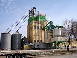
North Industrial Suburban Development Area (SDA) is located in the city of Saskatoon, Saskatchewan, Canada. Lower provincial corporate tax rates, no more provincial capital tax, and industrial lease and purchase rates which have stabilized very competitively with neighboring provinces have produced a demand for industrial property which exceeds supply. North Saskatoon Business Association (NSBA) promotes business interests in the Northern Industrial sector of Saskatoon.

<span class="mw-page-title-main">University Heights SDA, Saskatoon</span> Place in Saskatchewan, Canada

University Heights Suburban Development Area (SDA) is an area in Saskatoon, Saskatchewan (Canada). It is a part of the east side community of Saskatoon. It lies (generally) south of the outskirts of the City and the Rural Municipality of Corman Park No. 344, east of the South Saskatchewan River, and Lawson SDA, north of the Lakewood SDA, and Nutana SDA.

<span class="mw-page-title-main">Silverspring, Saskatoon</span> Neighborhood in Saskatoon, Saskatchewan, Canada

Silverspring is a residential neighbourhood located in northeast Saskatoon, Saskatchewan, Canada. It is a suburban subdivision, composed mostly of low-density, single detached houses. As of 2007, the area is home to 4,936 residents. The neighbourhood is considered a high income area, with an average family income of $85,084, an average dwelling value of $322,670 and a home ownership rate of 97.8%. According to MLS data, the average sale price of a home as of 2013 was $407,171.

<span class="mw-page-title-main">Central Business District, Saskatoon</span> Neighbourhood in Saskatoon, Saskatchewan, Canada

The Central Business District is one of seven development districts in Saskatoon, Saskatchewan, Canada. The central business district is Ward 6 of a Mayor-Council government represented by councillor Cynthia Block. Formerly called West Saskatoon, this area arose when the steam engines built their pumping stations on the lower west bank of the South Saskatchewan River. Retail enterprises sprang up around the newly created train station and rail yards. The city of Saskatoon's Central Business District has shopping malls and boutiques.

<span class="mw-page-title-main">College Park, Saskatoon</span> City of Saskatoon neighbourhood in Saskatchewan, Canada

College Park is a primarily residential neighbourhood located in the east-central part of Saskatoon, Saskatchewan, Canada. The majority of its residents live in single-family detached dwellings, with a sizable minority of high-density, multiple-unit dwellings. As of 2011, the area is home to 5,470 residents. The neighbourhood is considered a middle-income area, with an average family income of $65,133, an average dwelling value of $232,228 and a home ownership rate of 58.9%.

<span class="mw-page-title-main">Wildwood, Saskatoon</span> City of Saskatoon neighbourhood in Saskatchewan, Canada

Wildwood is a primarily residential neighbourhood located in the southeast part of Saskatoon, Saskatchewan, Canada. It includes part of the 8th Street business district. The majority of its residents live in a townhouse or apartment-style multiple unit dwellings, with a sizeable minority of low-density, single detached dwellings. As of 2016, the area is home to 7,645 residents. The neighbourhood has an average family income of $37,770, a homeownership rate of 67.0% and an average home sale price of $300,327.

<span class="mw-page-title-main">Kelsey-Woodlawn, Saskatoon</span> Neighbourhood in Saskatoon, Saskatchewan, Canada

Kelsey-Woodlawn is a combination of industrial park nestled between the North West Industrial SDA and the Central Industrial of down town Saskatoon. It is still serviced by the CNR rail lines to both the north and east. There are two older neighbourhoods, one still survives near SIAST - Kelsey institute on Idylwyld Drive North, and the other is the McVicar Addition near the Woodlawn Cemetery.

<span class="mw-page-title-main">Central Industrial, Saskatoon</span> Neighbourhood in Saskatoon, Saskatchewan, Canada

Central Industrial is a light industrial area in Saskatoon, Saskatchewan, Canada, that comprises educational, recreational facilities, hotels and businesses along Idylwyld Drive. The community meets up with the Central Business District CBD to the west and south, and residential areas east and north.

<span class="mw-page-title-main">Lakeview, Saskatoon</span> City of Saskatoon neighbourhood in Saskatchewan, Canada

Lakeview is a primarily residential neighbourhood located in the southeast part of Saskatoon, Saskatchewan, Canada. The majority of its residents live in low-density, single detached dwellings, with a sizeable minority of semi-detached or apartment-style multiple unit dwellings. As of 2011, the area is home to 7,732 residents. The neighbourhood is considered a high income area, with an average family income of $120,042, an average dwelling value of $277,070 and a home ownership rate of 71.0%. It was the first community in Saskatoon to feature a man-made lake amenity.

<span class="mw-page-title-main">Montgomery Place, Saskatoon</span> Neighbourhood in Saskatoon, Saskatchewan, Canada

Montgomery Place is a post-World War II community erected for veterans outside Saskatoon, Saskatchewan, Canada, that consists primarily of residential homes. It was amalgamated within the city of Saskatoon in 1956, and is now a National Historic Site. Montgomery Place has an average household size of 3.2 persons, and homeownership is at 93.7%. According to MLS data, the average sale price of a home as of 2013 was $403,840. It was named in honour of Field Marshal The 1st Viscount Montgomery of Alamein, the famous Ulster Scots commander in the British Army during the Second World War.

<span class="mw-page-title-main">History of Saskatoon</span>

The history of Saskatoon began with the first permanent non-indigenous settlement of Saskatoon, Saskatchewan, Canada, in 1883 when Toronto Methodists, wanting to escape the liquor trade in that city, decided to set up a "dry" community in the rapidly growing prairie region. As of 1882 this area was a part of the provisional district named Saskatchewan, North-West Territories (NWT). Their organization, the Temperance Colonization Society, first examined this area in 1882 and found that it would make an excellent location to found their community based on the ideals of the temperance movement; Saskatoon traditionally considers 1882 its founding year and thus marked its centennial in 1982. The settlers, led by John Neilson Lake, arrived on the site of what is now Saskatoon by traveling by railway from Ontario to Moose Jaw, Assiniboia, NWT, and then completing the final leg via horse-drawn cart. The plan for the Temperance Colony soon failed as the group was unable to obtain a large block of land within the community. Nonetheless, John Lake is commonly identified as the founder of Saskatoon; a public school, a park and two streets are named after him.

<span class="mw-page-title-main">Greystone Heights, Saskatoon</span> City of Saskatoon neighbourhood in Saskatchewan, Canada

Greystone Heights is a mostly residential neighbourhood located in east-central Saskatoon, Saskatchewan, Canada. It is a suburban subdivision, consisting mostly of low-density, single detached dwellings and a sizeable minority of apartment-style multiple-unit dwellings. As of 2007, the area is home to 2,525 residents. The neighbourhood is considered a middle-income area, with an average family income of $58,811, an average dwelling value of $241,850 and a home ownership rate of 58.1%.

<span class="mw-page-title-main">Saskatoon station (Canadian Pacific Railway)</span>

Saskatoon station is a historic railway station building in Saskatoon, Saskatchewan, Canada. It was built in 1908. It was designated a National Historic Site of Canada in 1976, and has also been protected as a Heritage Railway Station of Canada since 1990.

<span class="mw-page-title-main">Forest Grove, Saskatoon</span> Neighbourhood in Saskatoon, Saskatchewan, Canada

Forest Grove is a primarily residential neighbourhood located in northeast Saskatoon, Saskatchewan, Canada. It is mostly made up of low-density single detached dwellings, with a sizeable minority of multiple-unit apartment dwellings. As of 2011, the area is home to 5,907 residents. The neighbourhood is considered a middle-income area, with an average family income of $70,487, an average dwelling value of $246,680 and a home ownership rate of 62.4%.

<span class="mw-page-title-main">University Heights Suburban Centre, Saskatoon</span> Neighbourhood in Saskatoon, Saskatchewan, Canada

University Heights Suburban Centre is a mixed-development neighbourhood located in northeast Saskatoon, Saskatchewan, Canada. It is a classified as a "suburban centre" subdivision, composed of medium to high-density multiple-unit dwellings, commercial areas and civic facilities. As of 2009, the area is home to 1,479 residents. The neighbourhood is considered a middle-income area, with an average family income of $69,219, an average dwelling value of $237,698 and a home ownership rate of 85.7%. According to MLS data, the average sale price of a home as of 2013 was $304,903.

<span class="mw-page-title-main">C.N. Industrial, Saskatoon</span> Neighbourhood in Saskatoon, Saskatchewan, Canada

The CN Industrial Area is the industrial subdivision located in southern Saskatoon. It is also known as South Saskatoon, after the CN rail siding located in the area. It is a part of the Nutana Suburban Development Area. This industrial park was established with the Grand Trunk Pacific Railway crossing the South Saskatchewan River.

<span class="mw-page-title-main">South West Industrial, Saskatoon</span> Neighbourhood in Saskatoon, Saskatchewan, Canada

South West Industrial, also known as Holiday Park Industrial and labelled SEDCO Industrial on city maps of the 1980s and 1990s, is an industrial subdivision located in the Confederation SDA in southwest Saskatoon, Saskatchewan, Canada.

<span class="mw-page-title-main">C.N. Yards Management Area</span> Neighbourhood in Saskatoon, Saskatchewan, Canada

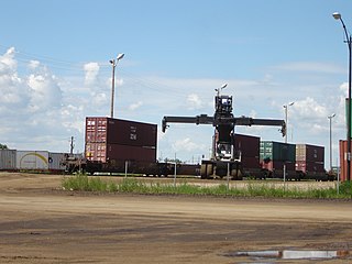
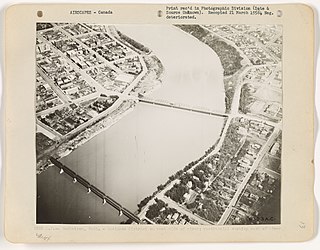
The Canadian National Railway (C.N.) Yards Management Area located on Chappell Drive, Saskatoon, Saskatchewan consists of the VIA Saskatoon railway station and the train switching yards. These yards are a part of the Confederation Suburban Development Area (SDA). It lies (generally) north of the outskirts of the City and the Rural Municipality of Corman Park No. 344, west of Montgomery Place, south of 11th Street and east of Highway 7. Highway 7 has built an overpass over C.N. tracks where they intersect. This neighbourhood is not to be confused with the C.N. Industrial in the Nutana SDA on the east side of Saskatoon. These two sides of Saskatoon are connected with the Grand Trunk Bridge or CN railway bridge over the South Saskatchewan River.

References

  1. "First urban reserve celebrates 20 years". The StarPhoenix . CanWest. March 4, 2008. Archived from the original on January 18, 2013. Retrieved 2012-10-16.
  2. Populace Spring 2006, vol. 8, City of Saskatoon - City Planning Branch, Spring 2006, p. 5
  3. 1 2 "Sutherland Local Area Plan - Final Report" (PDF). City of Saskatoon - City Planning Branch. 1999-02-08. p. 10. Retrieved 2012-10-16.[ permanent dead link ]
  4. "Exploring the Wonder City". Driving Tour. City of Saskatoon - Archives. 2006. Archived from the original on 2012-02-06. Retrieved 2012-10-16.
  5. Jeff, O'Brien (July 2005). "A History of Saskatoon to 1914" (PDF). City of Saskatoon - Archives. Archived from the original (PDF) on 2011-07-21. Retrieved 2012-10-16.
  6. Jeff, O'Brien (July 2005). "Saskatoon Chronology: 1882-2005" (PDF). City of Saskatoon Archives. Archived from the original (PDF) on 2011-07-06. Retrieved 2012-10-16.
  7. O'Brien, Jeff; Ruth W. Millar; William P. Delainey (2006). Roberta Coulter (ed.). Saskatoon: A History in Photographs. Coteau Books. p. 30. ISBN   1-55050-336-7.
  8. 1 2 "Frequently Asked Questions" (PDF). Urban Reservers. City of Saskatoon. Retrieved 2012-10-16.[ permanent dead link ]
  9. Legislative Assembly of Saskatchewan - Members of the Legislative Assembly , retrieved 2017-04-16
  10. City Councillors - Saskatoon.ca , retrieved 2017-04-16
  11. "City of Saskatoon Development Plan - Land Use Map" (PDF). City of Saskatoon - Community Services - City Planning. 2012-09-17. Archived from the original (PDF) on 2014-07-14. Retrieved 2012-10-16.
  12. Hutton, David (June 23, 2009). "City, CP agree to study move of downtown yard". The StarPhoenix . Canwest. p. A3. Archived from the original on January 18, 2013. Retrieved 2012-10-16.

Further reading