Caswell Hill, Saskatoon

Last updated

Caswell Hill
CaswellHillHomes.jpg
Caswell Hill Homes
Coordinates: 52°08′25″N106°40′32″W / 52.14028°N 106.67556°W / 52.14028; -106.67556
Country Canada
Province Saskatchewan
City Saskatoon
Suburban Development Area Core Neighbourhoods SDA
Government
  TypeMunicipal (Ward 2)
  Administrative body Saskatoon City Council
  Councillor Hilary Gough
Population
 (2005) [1]
  Total3,505
   Average Income
$40,217
Time zone UTC-6 (CST)
Orthodox Church OrthodoxChurch.jpg
Orthodox Church

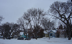
Caswell Hill is a district in the city of Saskatoon, Saskatchewan, Canada. It derives its name from an early homesteader Robert Caswell one of the Temperance Colonists of 1883. It is an area of beautiful character homes first built ca. 1905, tiny war-time houses, and newer houses. Caswell is a thriving and diverse community nestled between two economic areas, the downtown core, and the stores lining 33rd Street West.

Contents

Caswell Hill is bounded by 22nd Street to the south, H Avenue to the west, 33rd Street to the north, and Idylwyld Drive to the east. [2]

Layout

Streets are laid out east and west, avenues are laid out running north and south. Streets increment in number as travel heads northward. Avenues increment alphabetically as travel proceeds west. The whole of the Caswell Hill community is also laid out in a grid pattern. [3]

Historic sites

Saskatoon Railway Station (Canadian Pacific) is one of many Saskatoon buildings listed in the Canadian Register of Historic Places. It is a Château style station which was built in 1907. Its current address is 305 Idylwyld Drive North, Idylwyld Drive used to be called Avenue A. [4]

Government and politics

Caswell Hill exists within the federal electoral district of Saskatoon West. It is currently represented by Brad Redekopp of the Conservative Party of Canada, first elected in 2019. [5]

Provincially, the area is mostly within the constituency of Saskatoon Centre. It is currently represented by Betty Nippi-Albright of the Saskatchewan New Democratic Party, first elected in 2020. [6] The northern tip of the neighbourhood northeast of 32nd Street and Avenue I lies within the constituency of Saskatoon Westview. [7]

In Saskatoon's non-partisan municipal politics, King George lies within ward 2. It is currently represented by Hilary Gough, first elected in 2016. [8]

Education

Caswell Community School
CaswellSchool.jpg
Location
Caswell Hill, Saskatoon
204 - 30th Street West

, ,
S7L 0N9

Information
TypeElementary
Opened1910 (1910)
School board Saskatoon Public Schools
PrincipalKendall Pierce
GradesKindergarten to Grade 8
Enrollment217 [9]  (2017)
Education systemPublic
LanguageEnglish
Feeder to Bedford Road Collegiate
Website Caswell Community School

Shopping

Mayfair Hardware MayfairHardware.jpg
Mayfair Hardware
25th Street Grocery 25thStreet Grocery.jpg
25th Street Grocery

Small shops, cafes, and amenities line both sides of 33rd Street West.

Area parks

Swimming facilities

Transportation

City transit

Caswell Hill is serviced by City Transit Bus Routes and since 1913, has housed the city's original streetcar building at Avenue C and 24th Street. The city transit headquarters afterwards adopted these buildings for bus warehouse garages and offices between Avenue C and D at 24th Street. A seven million CA$ consultant plan has been approved by the Saskatoon planning and operations committee to relocate the transit bus barns. The Caswell neighbourhood will be revitalized by renovating the 13-acre (53,000 m2) area with a community for artists and musicians enhanced with a music festival. [12]

22nd Street (Highway 14) is a major thoroughfare through Saskatoon. Highway 7 has its junction at (Highway 14. Highway 14 connects with Asquith, Biggar Wilkie, Unity, and Macklin en route to Alberta.

Idylwyld Drive has had many titles: Avenue A, (Highway 11 and most currently Louis Riel Trail. It is a main thoroughfare through the city connecting Regina, Saskatoon and Prince Albert, Saskatchewan. It also connects west Saskatoon with the bedroom communities of Warman and Martensville

Life

Caswell Community Association provides leisure activities for various age groups and operates out of Caswell School [13]

Related Research Articles

Highway 219 is a provincial highway in the Canadian province of Saskatchewan. Saskatchewan's 200-series highways primarily service its recreational areas. The highway runs from Gardiner Dam at the north end of Lake Diefenbaker north to the city Saskatoon. It is about 96 kilometres (60 mi) long.

<span class="mw-page-title-main">Meadowgreen, Saskatoon</span> Neighborhood in Saskatoon, Saskatchewan, Canada

Meadowgreen is a neighbourhood located on the west side of the city in the Confederation Suburban Development Area in the city of Saskatoon, Saskatchewan, Canada. Meadowgreen is surrounded by an abundance of green space and walking trails without being a River side neighbourhood. The buffer zone along Circle Drive has a newly created walking trail. The southern buffer zone along 11th Street connects to the east with Fred Mendel Park of the Pleasant Hill neighbourhood and to the west with the off leash dog run located in the Confederation Suburban Centre neighbourhood. As well the newly re-located Meadowgreen Park and Peter Pond Park provide leisure activities such as basketball courts and playgrounds. Within the Confederation SDA of Saskatoon, the neighborhood of Meadowgreen comprises the area south of 22nd Street, north of the buffer zone between 11th Street and Appleby Drive, east of Circle Drive, and west of Avenue W South. Until the 1990s the portion of the community north of 18th Street was considered part of the Pleasant Hill community until the City of Saskatoon reorganized its community boundaries.

<span class="mw-page-title-main">Confederation SDA, Saskatoon</span> Place in Saskatchewan, Canada

Confederation Suburban Development Area (SDA) is an area in Saskatoon, Saskatchewan (Canada). It is a part of the west side community of Saskatoon. It lies (generally) north of the outskirts of the City and the Rural Municipality of Corman Park No. 344, west of downtown Saskatoon, and the Core Neighbourhoods SDA, south of the North West Industrial SDA, and east of the new Blairmore SDA.

<span class="mw-page-title-main">Central Business District, Saskatoon</span> Neighbourhood in Saskatoon, Saskatchewan, Canada

The Central Business District is one of seven development districts in Saskatoon, Saskatchewan, Canada. The central business district is Ward 6 of a Mayor-Council government represented by councillor Cynthia Block. Formerly called West Saskatoon, this area arose when the steam engines built their pumping stations on the lower west bank of the South Saskatchewan River. Retail enterprises sprang up around the newly created train station and rail yards. The city of Saskatoon's Central Business District has shopping malls and boutiques.

<span class="mw-page-title-main">Pleasant Hill, Saskatoon</span> Saskatoon Neighbourhood in Saskatchewan, Canada

Pleasant Hill is a neighbourhood of Saskatoon, Saskatchewan, Canada. The Governments are undertaking a major re-vitalization project of Pleasant Hill. $3.5 million is being invested in the business, and residential areas as well as in St. Mary's School. Together the Saskatoon Urban Renewal Project, the provincial government and the Western Economic Diversification project of the federal Government will result in neighbourhood overhauls. 29 lots zoned for business along 20th Street will be levelled and modern commercial upgrades put into place. Selected lots along Avenue N and Avenue O zoned as residential will be demolished to make way for affordable and decent homes. St. Mary's School will receive major renovations or replacement, possibly even a new community centre.

<span class="mw-page-title-main">Mayfair, Saskatoon</span> Neighbourhood in Saskatoon, Saskatchewan, Canada

Mayfair is a neighbourhood in the city of Saskatoon, Saskatchewan, Canada. Mayfair started out as a community outside of the villages of Riversdale, Nutana and Saskatoon and appears as its own place name on a map of 1907. In 1909 there were 60 residences built in Mayfair, and in 1911, the City of Saskatoon had grown large enough to encompass Mayfair. Homeownership amongst the residents is at 68.2%.

Massey Place, is a geographically localised subdivision of the Confederation Suburban Development Area in the city of Saskatoon, Saskatchewan which is nestled around Archibald McDonald Park. Mcdonald Park is centrally located along the northern perimeter of 33rd Street East. The school yards of both Vincent Massey School and Bishop Klein School have their western boundaries along Archibald McDonald Park which has as its resources ball diamonds, soccer pitches, winter ice rinks, and playground facilities. Massey Place neighbourhood is close to amenities provided by both the commercial district of the Confederation Suburban Centre.

<span class="mw-page-title-main">North Industrial, Saskatoon</span> Neighbourhood in Saskatoon, Saskatchewan, Canada

North Industrial is an established industrial community in the city of Saskatoon, Saskatchewan, which consists primarily of industrial and retail development.

<span class="mw-page-title-main">Kelsey-Woodlawn, Saskatoon</span> Neighbourhood in Saskatoon, Saskatchewan, Canada

Kelsey-Woodlawn is a combination of industrial park nestled between the North West Industrial SDA and the Central Industrial of down town Saskatoon. It is still serviced by the CNR rail lines to both the north and east. There are two older neighbourhoods, one still survives near SIAST - Kelsey institute on Idylwyld Drive North, and the other is the McVicar Addition near the Woodlawn Cemetery.

<span class="mw-page-title-main">Central Industrial, Saskatoon</span> Neighbourhood in Saskatoon, Saskatchewan, Canada

Central Industrial is a light industrial area in Saskatoon, Saskatchewan, Canada, that comprises educational, recreational facilities, hotels and businesses along Idylwyld Drive. The community meets up with the Central Business District CBD to the west and south, and residential areas east and north.

<span class="mw-page-title-main">Blairmore SDA, Saskatoon</span> Place in Saskatchewan, Canada

Blairmore Suburban Development Area (SDA) is an area in Saskatoon, Saskatchewan (Canada). It is a part of the west side community of Saskatoon. It lies (generally) north of the outskirts of the City and the Rural Municipality of Corman Park No. 344, west of downtown Saskatoon, and the Core Neighbourhoods SDA, south of the North West Industrial SDA, and west of the Confederation SDA. Most of the Blairmore SDA consists of undeveloped land annexed by the city in the mid-2000s. A total of nine neighbourhoods, primarily residential in nature, are ultimately planned for the SDA. As of late 2019, two are in the process of development: the commercial/residential Blairmore Suburban Centre and the residential community Kensington. A third residential area, Elk Point, is also in its early stages.

<span class="mw-page-title-main">Avalon, Saskatoon</span> Neighbourhood in Saskatoon, Saskatchewan, Canada

Avalon is a mostly residential neighbourhood located in south-central Saskatoon, Saskatchewan, Canada. It is a suburban subdivision, consisting mostly of low-density, single detached dwellings. As of 2007, the area is home to 3,214 residents. The neighbourhood is considered a middle-income area, with an average family income of $65,000, an average dwelling value of $168,444 and a home ownership rate of 77.3%.

<span class="mw-page-title-main">North Park, Saskatoon</span> Neighbourhood in Saskatoon, Saskatchewan, Canada

North Park is a community which is just to the north of the Meewasin Riverworks observation area and the CPR Bridge. It has access along its eastern perimeter to the scenic walking trails along the South Saskatchewan River developed by the Meewasin Valley Authority. The average home selling price in 2006 was $101,176- $139,704. Each family was approximately 2.1 residents, and 63.9% of the residents owned their own home.

<span class="mw-page-title-main">Richmond Heights, Saskatoon</span> Neighbourhood in Saskatoon, Saskatchewan, Canada

Richmond Heights, adjacent to the South Saskatchewan River, features walking trails in the Meewasin Valley. G.D. Archibald Park North hosts baseball and soccer games. Luther Heights is a Luther care community for those aged 60 and over. In 2006, 73.5% of the residents owned their own home; the average home size was 2.3 residents.

<span class="mw-page-title-main">Dundonald, Saskatoon</span> Neighbourhood in Saskatoon, Saskatchewan, Canada

Dundonald is a neighbourhood located in the northwest corner of Saskatoon, Saskatchewan. The neighbourhood was built in the 1980s, and served as the last development of the northwest corner of the city, prior to the development of Hampton Village. Dundonald is surrounded by a large landscaped park, with a storm pond. In comparison, the neighbourhood of Dundonald with a 2001 census population of 5,285 is larger than the Saskatchewan city of Melville which had a population of 4,149 in 2006, and 4,453 in 2001 and Dundonald is also larger than the provincial city of Humboldt which was 4,998 in 2006, and 5,161 in 2001. In Saskatchewan rural towns must maintain a population above 5,000 to apply for city status.

<span class="mw-page-title-main">Hudson Bay Park, Saskatoon</span> Neighbourhood in Saskatoon, Saskatchewan, Canada

Hudson Bay Park is geographically located in north west Saskatoon just south of Circle Drive along 33rd Street and Avenue P North. It is mainly characterized by single detached homes along with apartments that are less than five stories in height. Oliver Place and St. Joseph's Home are seniors residences located in this residential neighbourhood. This locale honours the pioneers of Saskatoon, as well as providing two very large park spaces which curve through the neighbourhood. The community was under construction mainly during the post war years between 1940 and 1960 when there was a housing shortage. The land for this neighbourhood was annexed during the City expansion around the time of 1910 to 1915. Following elementary school, students usually attend Mount Royal Collegiate in the neighboring area of Mount Royal or E.D. Feehan Catholic High School on Avenue M North a part of Westmount community. In 2006, the average family size was 2.1 residents. Statistics c2005 -

<span class="mw-page-title-main">Circle Drive</span> Road in Saskatoon, Saskatchewan

Circle Drive is a major road constructed as a ring road in Saskatoon, Saskatchewan, Canada. Its route constitutes both part of the Yellowhead Highway and Highway 11, signed as both along the entire length. It was first conceived in 1913 by the city commissioner and completed exactly 100 years later in 2013. Most of the route is a fully-controlled access freeway, however the segment between Airport Drive and Millar Avenue has at-grade intersections.

<span class="mw-page-title-main">Idylwyld Drive</span> Street in Saskatoon, Saskatchewan, Canada

Idylwyld Drive is an arterial road in Saskatoon, Saskatchewan. It is one of the main roads in and out of the downtown area of the city.

Kensington is a neighbourhood located in west Saskatoon, Saskatchewan, Canada that began construction in 2013. Around 2028, Kensington will reach completion and have an estimated population of 8,300. Kensington will feature Saskatoon's first application of the fused grid street network.

22nd Street is an arterial road in Saskatoon, Saskatchewan. It begins as 22nd Street East in the Central Business District. Going west it passes the Midtown Plaza and TCU Place. At the intersection with Idylwyld Drive, it becomes 22nd Street West. Through the inner city neighbourhoods of Caswell Hill, Riversdale, Westmount, and Pleasant Hill, it contains a mixture of commercial and residential development. It then connects with Circle Drive via an interchange. Next to the interchange is the Confederation Mall. Across from that is a Real Canadian Superstore. From there is passes by the neighbourhoods of Pacific Heights, Blairmore, and Kensington. The road then heads out of the city and continues on as Highway 14.

References

  1. Neighborhood Profiles Caswell Hill Archived 2006-06-27 at the Wayback Machine URL accessed February 4, 2007
  2. "Caswell Hill" (PDF). City of Saskatoon. Retrieved 2020-04-11.
  3. Selling an Idea or a Product Archived September 29, 2007, at the Wayback Machine URL accessed January 27, 2007
  4. Historic Places – The Register URL accessed February 24, 2007
  5. Current Members of Parliament , retrieved 2020-02-20
  6. Legislative Assembly of Saskatchewan - Members of the Legislative Assembly , retrieved 2017-04-16
  7. Map of Provincial Constituencies in Saskatoon (PDF), retrieved 2017-04-16
  8. City Councillors - Saskatoon.ca , retrieved 2017-04-16
  9. Active List of Saskatchewan Schools/Programs (PDF), retrieved 2018-02-10
  10. A SEAT ON COUNCIL - The Aldermen, Councillors and Mayors of Saskatoon - 1903-2006 URL accessed Tue, February 5, 2019
  11. Blashill, Lorraine (1982). Lorraine Blashill (ed.). From a little stone school... A story of Saskatoon Public Schools. Modern Press Ltd. p. 29.
  12. Beaudry, Morgan (March 19–25, 2010). "Caswell Hill Overhaul Approved". VerbNews.com. p. 2.
  13. [CaswellHill.ca] URL accessed February 2, 2007